blankblank blank


Author Archive for Leszek Pawlowicz Page 36 of 79


Clickable World Climate Map

The World Weather Map lets you click on a location, and get a plot by month of temperature (max/average/min), rainfall, and average number of hours of sunshine. A fourth tab supposedly gives you “Experiences”, a link list of things to do at that location, but the list sometimes includes activities a long distance (> 100 miles) from that location. You can also add an overlay showing what areas are “Hot”, “Warm” or “Wet” for a particular month.

The main website’s map is also flawed in that there’s no zoom feature, so for areas where the climate can change dramatically over a short distance (like the American Southwest), getting the climate for the exact location you want can be difficult to impossible. (1/24/2008: Fixed by the good folks at WorldReviewer; see the comment below) Oddly enough, there’s a widget version of this map that does include a zoom feature, and which can be embedded in any website, as below. Click and drag to move the map; click on +/- to zoom in and out; click on any point to get the climate data for that location:

For more specific climate data, downloadable for any location on the Earth, try some of the applications described in this post. Via GoogleMapsMania.


More Degree-Minute-Second Converter Options

A commenter on yesterday’s post asks if I know of any programs that will convert a list of coordinates in degree-minute-second format to decimal degrees. Haven’t tried it, but Zonums Software has a free Excel macro called Ectrans that will supposedly convert a spreadsheet list of coordinates in degree-minute second format to decimal degrees (and vice versa), or one set of coordinates at a time manually. It also converts spreadsheet coordinate lists from lat/long to UTM and back again. If you don’t have Excel, it might work with OpenOffice, since I hear rumors that OpenOffice may support some VBA macros.

Zonums also has online decimal-DMS converters for converting one point at a time, adding them to a text box that can be copied and pasted as a CSV spreadsheet file; points can also be plotted on a Google Maps interface. There are also online lat/long to UTM converters accessible from the same page, but they don’t appear to be working currently.

From comments in yesterday’s post, Dylan Beaudette describes how to do it using FWTools (command-line, run away! ;-):

1. convert DD -> DMS:
cs2cs +proj=latlong +datum=NAD83 +to +proj=latlong +datum=NAD83

2. convert DMS -> DD
cs2cs -f “%.6f” +proj=latlong +datum=NAD83 +to +proj=latlong +datum=NAD83

If you invoke the command as listed above (without reference to a data stream) you will get an interactive prompt. This approach is a lot more useful when you have a file full of coordinates, or a stream of coordinates:

cs2cs +proj=latlong +datum=NAD83 +to +proj=latlong +datum=NAD83 < DD_coords.txt > DMS_coords.txt

Also from the comments, for programmers, Aron Rubin posts code for a C function that will do the conversion.


Free Neighborhood Boundary Shapefiles

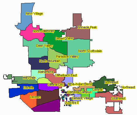
Zillow has released shapefile boundaries describing neighborhoods in 150 major cities, grouped by state. Available under the Creative Commons license, they’re free for general use in any application as long as you attribute Zillow as the source. Coverage is still limited; in Arizona, only the two largest urban areas (Phoenix and Tucson) are included. But Zillow encourages submissions of neighborhood boundaries for cities not currently covered in their database, and will work on including those submissions after they’re verified. Projection is geographic (latitude/longitude), NAD83.

phoenix neighborhoods

Phoenix neighborhoods (created with the TatukGIS Viewer)

Via the James Fee GIS Blog.


Degree-Minute-Second To Decimal Degree Converter

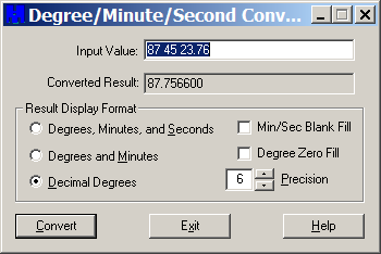
Someday, working with latitude/longitude in degrees-minutes-seconds will be a bad memory, and everyone will use either decimal degrees or rational metric units like UTM exclusively. But until that happy day, if you need a desktop utility to easily convert from degrees-minutes-seconds to decimal degrees or degrees-minutes (and the opposite direction as well), you may find it useful to have the Degree/Minute/Second Converter from Mentor Software handy. It’s a small download at 307 kB with a full installer, but make note of which Start Menu folder it puts the shortcuts in (default is Accessories). Operation is dead simple:

dms

Enter the degrees, minutes and seconds separated by spaces, set the number of decimal places with the Precision option, select the result type you want, then click Convert. It converts in the opposite sense directly, i.e. enter a decimal degree and have it converted to degrees-minutes or degrees-minutes-seconds. In this latter mode, checking Min/Sec Blank Fill removes the zero from the front of single digit minutes and seconds (e.g. 1 instead of 01 minute, 4.2 instead of 04.2 seconds). Can’t quite figure out what Degree Zero Fill does, though ….


Six Free Must-Have Applications For Your Handheld GPS

The logs for this blog indicate a lot of visitors have come by recently looking for information on using handheld GPS units (Christmas gifts, perhaps?). So for those newcomers, I thought I’d do a quick roundup of the free applications I’ve found to be among the best for a variety of handheld-GPS-related tasks, along with some worthy alternatives that also have something to offer. Most are Windows-only, but a few are also available in native format for Mac and Linux, and may well run in Mac under Parallels/Boot Camp and Linux under WINE.

Downloading/uploading point and track information

While most handheld GPS units let you create waypoints, routes and sometimes tracks directly, their small size and limited input options can make this difficult and time-consuming. These programs speed up and simplify that process tremendously.

Best: GPS TrackMaker

While I use this program mainly for downloading and uploading data files in a variety of formats (GPX, KML, SHP, MMC and more), the program has many more useful options for creating waypoints and tracks, simplifying existing tracks, altitude profiles, even interfaces for working with Google Earth and Google Maps. Supports 160 different GPS models. More info.

Worthy alternative: EasyGPS

GPS TrackMaker has lots of features, but that can make the interface a bit cluttered. If you’re only interested in working with GPX or LOC files, EasyGPS is a clean, simple alternative that also supports GPS models from a wide range of manufacturers. More info.

GPS datafile creation with maps

If you want to create waypoints and routes by drawing them directly on a map, here are some options.

Best: USAPhotoMaps

USAPhotoMaps downloads USGS topo data, and one-meter black and white aerial imagery for the entire United Sates (0.25-meter color aerial imagery for some urban areas), and lets you create highly-accurate waypoints for export to a GPS unit. Route and track support, on the other hand, are pretty weak. More info.

Worthy alternative: You can always create points and tracks in Google Earth for export to a GPS (see below), or use an online service like TakItWithMe (more info) Digipoint 2 (more info) or quikmaps (more info) to take data created in a Google Maps interface to GPX format. But be aware that positions in Google Earth or Google Maps can be off slightly from their true position.

GPS file format conversion

There are dozens of formats for saving geographical data, but most GPS utilities only support a few of them. So it’s handy to have software that will convert from your obscure and bizarre format to one in more common use.

Best: GPSBabel

GPSBabel is the sine qua non of GPS format converters, handling more different formats than any other program I know. It’s a command line program, but comes with a GUI that, while not fully user-friendly allows reasonably easy access to most of its conversion capabilities. More info.

Worthy alternative: ITNConv

ITNConv handles a few formats that GPSBabel doesn’t, and also allows editing/creation of GPS data files in a Google Maps interface. More info.

Digital globe

Best: Google Earth

You probably already have Google Earth installed on your computer for general geographic browsing and exploration. But you may not know that in addition to its native data formats of KML/KMZ, Google Earth can also directly open GPX and LOC data files exported from your GPS, so you can see where you’ve been. If you want to connect your GPS directly to Google Earth, you could pay $20/year for Google Earth Plus, but I have a series of posts on getting Google Earth Plus features for free, along with some features GE+ doesn’t support, like exporting data from Google Earth to your GPS.

Worthy alternative: WorldWind

WorldWind was one of the earliest digital globes, and open source if that’s important to you. In some ways, it’s superior to Google Earth in its support of GPS, with built-in support for real-time GPS positioning in the main version. The free GPS2WorldWind plugin adds extensive support for importing and exporting data from/to Garmin GPS units, and limited support for other units through the NMEA interface.

Photo geotagging

Geotagging refers to embedding location data into the header of picture files, so that you can associate the picture with the location it was taken. Many free programs will do this automatically by matching a photo’s timestamp to the time you were at that location according to your exported GPS data. Geotagged photos can then automatically be displayed in a map program at the location they were taken; for example, Picasa can take geotagged photos and convert them into a KML file for display in Google Earth.

Best: GeoSetter

I’ve covered a fair number of photo geotagging tools on this blog (see the series listing at the end of the above post), but GeoSetter has the best mix of features and usability of any of them. More info.

Worthy alternative: GPicSync

Although it lacks some of GeoSetter’s features, GPicSync has a simpler interface that might appeal to some, and has some features that GeoSetter lacks. For example, you can associate audio and video files with the pictures, so that GPicSync will create links in the Google Earth / Google Maps files that link to the audio/video. More info.

GPS satellite visibility

The accuracy with which your GPS unit can determine your position depends partially on the number of satellites visible in the sky from your location, and also their geometry, i.e. how widely spaced apart in the sky they are. The more satellites there are, and the more widely-spaced they are in the sky, the more accurate your GPS-determined position will be. While most GPS units will give you a rough estimate of how accurate the current position it’s giving you is, they won’t tell you when during the course of a day you can expect to get the best (or worst) accuracy. For that info, try this program:

Best: Trimble Planning

Trimble Planning will calculate the relative degree of geometry-dependent accuracy for a specific location, and how it changes with time, presenting this data in easy-to-interpret graphic and tabular formats. A more detailed description of the program can be found here; more advanced users might want to take a look at my post on how to incorporate the effects of GPS satellite blockage by terrain on these accuracy calculations.

Worthy alternative: Live Satellites Google Earth UI (no longer available)
I used to link to Paul Seabury’s Live Satellites Google Earth UI, but that application has been pulled. Orbiting Frog has a similar application that is a bit more difficult to use, since you have to manually enter satellite parameters, but it’s still worth a look; see this post at the Google Earth blog for more info.

Looking for a GPS application that isn’t listed above? Try doing a search on this blog – I’ve covered dozens of different GPS applications in addition to the ones I’ve highlighted above.


Quick Zip Code Information

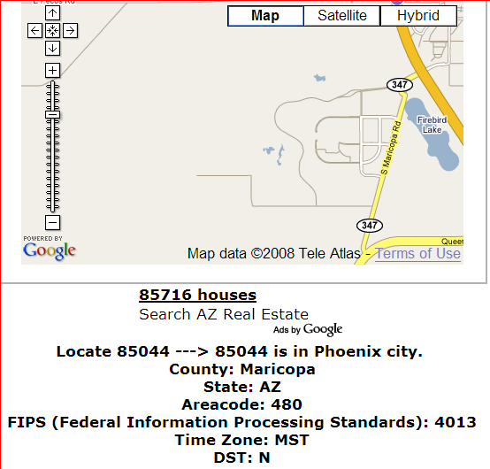
From the comments to my post on Mapping Zip And Area Code Boundaries comes a link to another, simpler site: ZipCodesMapped.Com. Type in a zip code, and get back the approximate location, area code, FIPS code, and timezone, along with a Google Maps window for the approximate area covered:

zipcode

The Google Maps window isn’t always 100% accurate – the example above is for my old neighborhood, and the displayed map doesn’t cover the entire area (though it is close). While it has less information than the USNaviguide website described in the original post, for quick lookups ZipCodesMapped.Com may be more convenient to use.


A Simple DBF Editor

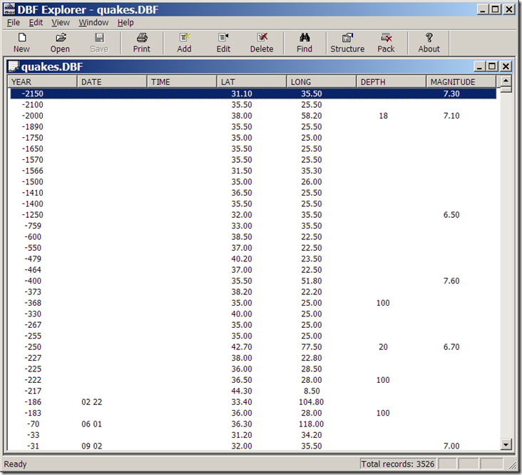
I’ve posted before about using OpenOffice’s Calc spreadsheet for use as a DBF editor (and why it doesn’t have the serious problem Excel 2003 has with editing DBF files). But Calc isn’t really designed to be a DBF file editor per se, which means that if, for example, you want to add new data columns to your shapefile’s DBF file, you’ll need to know a bit about column data formatting, and that’s kind of a pain. For basic DBF file editing, I find DBF Explorer easier to use, since it’s designed specifically and exclusively to work with DBF files. Adding and defining data column types is easy using the “Structure” button, as is modifying the values of individual data elements and searching for specific text elements (hint: use the Tab key to move to the data record you want to change). You can also delete full individual records, but that can easily screw up the relationship between the shape data and the associated DBF records, and should be done with care. Also be aware that the DBF file is updated continuously as you modify records, so if you want to keep the original unchanged, you should edit a copy of the original file.

Not a particularly fancy interface:

DBF Explorer

but it doesn’t need to be. And the help file tells you everything you need to know.

Addendum (1/29/08): Dave McGraw points out that if you use the “Structure” button to modify some of the parameters of an existing field, like the name, it will wipe out the data in that field, which is a bad thing; it will give you a warning first, though, that you may lose some data after such a modification. Other parameters, like field type and width, seem to be modifiable without nuking the original data; adding or deleting a field does not seem to cause any problems, either. Another argument in favor of editing a copy of the original, rather than the original itself.

The author also has some other free utilities on his site, including FTP/Web/Mail server software, and a simple install file builder.


Real-Time GPS/WAAS Status Reports

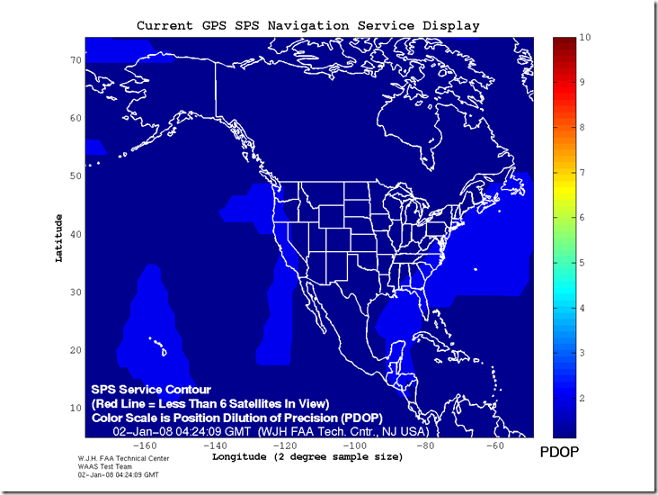
Not too long ago, I posted about a site that offers maps of GPS Dilution of Precision (DOP) for the US and the world for the next three days. The FAA’s WAAS test team has a website that offers both similar and complementary data. In addition to having maximum DOP maps for the current day, similar to the other site, it has real-time maps of the current DOP across the US:

SPS_big

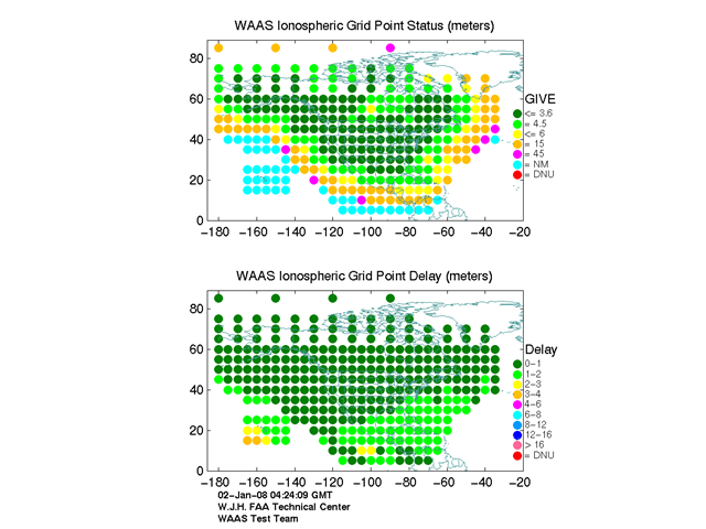
The actual delay in GPS signal due to ionospheric conditions:

igp_plot

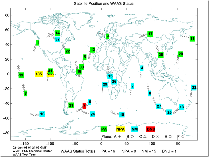
And the current real-time positions of all GPS/WAAS satellites above the earth, along with their status:

waas_sats

Along with many other GPS-related graphics and technical reports as well.