If you import data from a GPS unit into Google Earth, you may notice a mismatch between the plotted position of a waypoint or path and the actual position. Here’s an example of that from my neighborhood:
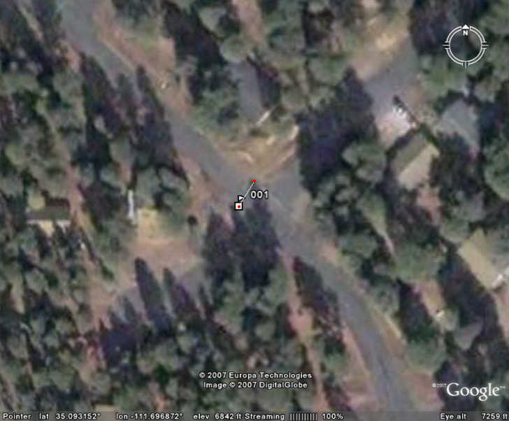
The flag marker is where Google Earth has plotted a GPS waypoint imported as a GPX file, while the drawn line that starts at that marker ends at the actual position where the GPS position was taken. The position plotted by Google Earth is about 30 feet off from the actual position. How come? There are at least two reasons:
1. GPS Error – Even though GPS units give positions to a precision eight decimal places in latitude and longitude, corresponding to an accuracy of about a millimeter or so, the true accuracy with which you can measure a position with GPS is far poorer than that. Consumer GPS unit manufacturers commonly quote an position accuracy figure of plus or minus 15 meters; while modern units can usually achieve better accuracy in real-world use, there is still likely to be some error in the position you measure with GPS. I’ll be covering techniques and tools for maximizing the accuracy of your GPS measurements in a future series of posts; suffice it to say that I took pains to get as accurate a measurement of that position with my GPS as possible.
2. The positions in Google Earth don’t necessarily coincide with the correct position on Mother Earth. In my neighborhood, an exact geographic location shows up offset about 30 feet in Google Earth, or pretty much what we see in the picture above.
So don’t expect to use GPS with Google Earth (or Google Maps) for high-precision positioning and mapping – it’s just not accurate enough for that.


A couple of other points:
* 3D Terrain – GE has terrain and the image is stretched over the terrain. The terrain is not detailed enough to be an exact match so the photo will be stretched differently.
* The image errors can be attributed to the fact Google uses a spherical WGS84 base model, not elliptical. But, more often it is due to the provider Google got the data from not accurately processing their imagery data. Google is trying to enforce better QA.
Good point about the terrain. I believe that Google Earth uses 30-meter terrain data for the US, but 90-meter for most of the rest of the world. So in areas of extreme topography, images won’t be “stretched” properly to fit the terrain. The Matterhorn in Switzerland was the classic example of this in Google Earth, but GE improved the accuracy of the elevation data there so that it renders more accurately now.
Google Earth says that it uses the standard elliptical WGS84 model:
http://earth.google.com/userguide/v4/ug_importdata.html
But even the elliptical model is too simplistic, and trying to wrap data in the geographic (Plate Carree) on such a simple model of the Earths’ shape will introduce additional errors.
The realestate usefullness of the garmin and google earth combination is hindered because the huge difference in accuracy.
Who is an expert in this ?