The Visible Paleo-Earth project has combined geological, paleontological, and paleoclimatological data with the paleogeographic maps of Ron Blakey (visible here and here) to create a series of Blue-Marble-type views of the earth spanning the last 750 million years:
Basic graphic imagery and the simple YouTube video animation below were released last week:
Basic graphic imagery and the simple YouTube video animation below were released last week:
More animations, and higher-resolution imagery, are scheduled to be released today (4/29/2011).
If you’re at all interested in the relationship between ancient geographies and climate, and how they created the geology of the Colorado Plateau, I highly recommend the book Ancient Landscapes by Ron Blakey and Wayne Ranney, a terrific synthesis of geology, geography, paleontology and cartography.
The British Geological Survey has made SIGMA, the System for Integrated Geologic Mapping, available for free:
The BGS·SIGMA project (System for Integrated Geoscience MApping) is an integrated workflow for geoscientific surveying and visualisation using digital methods for geological data visualisation, recording and interpretation in both 3D and 4D…
BGS·SIGMA has … defined and documented an underpinning framework of best practice for survey and information management, which has then informed the design brief and specifications for an integrated toolkit. This toolkit enables assembly and interrogation/visualisation of existing geological information, capture of new data and geological interpretations, and delivery of 3D digital products and services. We have made the 2nd version of our award-winning digital field data capture tool available free with the expectation that geoscientists globally can use the system and share any modifications or developments in future BGS releases.
There is a catch, though – you’ll need to have ArcGIS and Microsoft Access installed on your computer. And it’s primarily intended for use with field-rugged tablet PCs. You can download SIGMA here.
The US Department Of Agriculture’s Natural Resources Conservation Service (NRCS) – National Cooperative Soil Survey has a Web Soil Survey site that lets you query and access US soil data, but I’ve always found it slow and difficult to use. The California Soil Resource Lab at UC-Davis has created the SoilWeb data service, which recasts this data into a number of easier-to-use formats:
A Google Maps interface, which allows direct access to more detailed information for a soil unit. Scroll/zoom to an area, and see soil units plotted on the map, with a dynamic legend at right:
Click on a link to open a new page with links to more detailed info:
For example, clicking on the “Soil Type 1 Balon” link brings up a data page with the soil column, taxonomy, common vegetation types (if available), plus lots more:
Smartphone apps for both iPhone and Android, so you can view comparable soil data out in the field if you have Internet connectivity and a GPS position fix. See my review of the Android app here.
A text-only interface
A Google Earth file that offers similar maps and links to the Google Maps interface, but which I find less convenient to use.
And a HTTP SoilWeb API that allows for text-based and WMS queries
I’ve never really gotten interested in “geocaching”, the recreational sport of tracking down of hidden containers or cache by geographic location. But I’ve just found out about a related variant that meshes nicely with my interest in geology: EarthCache. As with a geocache, you go to a location based on geographical coordinates, but the reward is not tracking down a box or trinket, but seeing an area with interesting or unique geological features. Earthcaches are located around the world, with roughly half of them are in the United States. There’s a searchable index that lets you locate Earthcaches by country, state, and type (fossil site, erosional feature, igneous feature, etc.). Quick tip: for sites in America, choose “USA” for the country rather than “United States”’; the latter only has a few sites listed. Once you locate a site of interest, clicking on the link will take you to the information page for the site at Geocaching.com:
The information page generally includes a description of what makes the site interesting geologically, often with diagrams, photos and references. For full site coordinate data, you’ll need to register at the site and agree to a standard disclaimer, i.e. they’re not responsible for anything bad that might happen. Once registered, the coordinates will show up at the top, along with the option to download a LOC waypoint file. GPX file downloads require a paid membership, but LOC files can be opened using the free program EasyGPS and then either directly uploaded to your GPS or saved as a GPX file.
If you want to keep track of the sites you’ve visited, and get official recording of your visit at the Geocaching site, the info page will list off some required information, like photos, a general description, and several questions to answer about the geology. You can also leave comments about your visit, or read those of others before you go. And if you have a site that you think would make a good EarthCache, you can submit it. This is a great resource for both geology nuts and educators.
Make web-accessible the best available geological map data worldwide at a scale of about 1: 1 million, as a geological survey contribution to the International Year of Planet Earth.
While the official launch of the site is scheduled to coincide with the International Geological Conference in Oslo, August 6-14, the mapping portal site is already partially functional, although a few bugs and quirks still exist. It currently works with Internet Explorer 6/7, and Firefox 2, but not Firefox 3 (hope this changes soon). And while the goal is to have data for the whole world at a 1:1,000,000 scale, data for significant areas of the world are currently not available at that scale; for example, the US data is at the 1:5M scale. A partial list of the WMS data available and its scale is on this page.
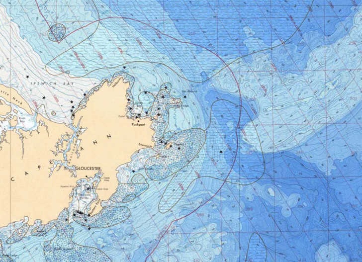
The National Geophysical Data Center has downloadable bathymetric and fishing maps for most of the US ocean coastline (not intended for navigation purposes, though). Map catalogs are broken down by geographic region, and maps are available in both small PDF preview format and large format downloads in either PDF or TIF format (the latter in gz compression, which will require an unzipping program like WinZip or ZipGenius). If you need the PDF maps in a editable graphic format, you can use a program like PDFCreator to “print” the PDF maps in full-resolution TIFF, JPG, or PNG formats. Maps are also not georeferenced (not GeoTiffs or GeoPDFs); I hope to cover some basic georeferencing options soon.
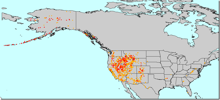
Living in the dry climate of the US Southwest, I’ve always found springs fascinating. For someone who grew up in the suburbs, water flowing continuously out of the ground with no pipeline or spigot somehow seems unnatural. But even more bizarre is hot water flowing out of the ground. NOAA’s National Geophysical Data Center has an online queryable map of Thermal Springs of the United States:
“Thermal” doesn’t necessarily mean “hot”; the orange dots indicate water temperatures of 20C – 50C, while red dots run from 50C all the way up to boiling. But in all these cases, the water from the spring is elevated above what comes out of other nearby springs that aren’t heated geothermally. Most are concentrated in the more geologically-active western states, but with a few exceptions (most notably, the ones in Arkansas that include Hot Springs National Park). Using the “Identify” control to click on a thermal spring brings up its lat/long, water temperature, USGS quad, and more info.
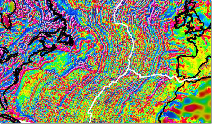
The BBC has an article on the release of the first worldwide map of magnetic anomalies, deviations in the earth’s magnetic field due to effects from magnetized crustal rocks. Nice views of the magnetic striping on either side of the Mid-Atlantic Ridge resulting from ocean-floor spreading (the driver of continental drift) and prehistoric reverses in the direction of the earth’s magnetic field:
Contents of the Free Geography Tools Blog copyright 2007-2018; all rights reserved.
Determining the accuracy, reliability, validity, or appropriateness of any of the software or data written about in this blog for any uses is the sole responsibility of the reader, not the authors of the blog posts. The blog authors have no liability for any uses of the software or data described here.
Shopping at Amazon through the link below helps support the site. Thanks!