I’ve posted about a fair number of applications for geotagging photographs, embedding the geographic location into the photo’s EXIF header either manually or by synchronizing the time the photographs were taken with a GPS GPX track file. So far, my favorites have been GPicSync and Location Stamper, but GeoSetter is my new program of choice. Among its features are:
- A convenient and easy to use photo album display and Google Maps interface
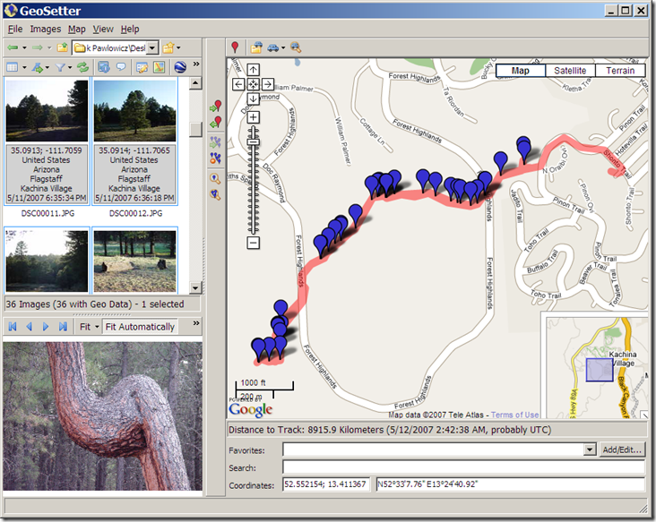
- Automated geotagging of photos with a GPX, NMEA, PLT or Sony LOG track, with adjustable time zone and time matching tolerance
- Synchronize untagged photos with geotagged photos taken at the same time/place
- Display of the track and position markers for the photo in a Google Maps window
- Automatic retrieval of the geographic location of a photo (e.g. the name of the nearest city, state and country) for embedding in the photo’s IPTC header
- The ability to manually edit the photo’s header, including not just the geographic data, but also the IPTC source/description, category/keywords, etc.
- You can also manually geotag a photo by creating a marker in the Google Maps interface, then associating that marker with the photo
- Export of selected photos to a Google Earth KML file, with or without the track file. While other programs have this capability, GeoSetter lets you also export your choice of any of the EXIF/IPTC header data associated with the photo to the KML file as well.
- Undo/Redo capability
- Eight different languages
- Unlike some of the other programs I’ve posted about, GeoSetter’s geotagging is recognized by Picasa
The biggest flaw with the program is the lack of a help file (a few functions are documented on the website), but the program is so easy to use, you won’t miss it that much.
Thanks to Robert Kluszczynski for letting me know about GeoSetter.


Hi!
Is there any Photo Geotagging App that export to Shape files?
I use a government program that only views SHP, not GPX.
Regards
/Thomas
I haven’t used it in this capacity, but DNRGarmin will link GPS points to photographs, puts the photo path and filename into a table, and lets you save it as a shapefile. Some GIS programs will let you view this photo data directly.
Thank you, I will test this in the New Year.
Merry Christmas!
Thanks for the time use on testing geo setting applications. I agree with you that GeoSetter is the best one out there (at least at the ones I have tested). The developer is also very quick with responsons, and are interested in discussion new features.
GeoSetter for Windows is updated:
History
v3.0.14 (11 February 2009)
* Updated to ExifTool 7.67
v3.0.4 (21. August 2008)
! Wrong behaviour with file type filters when changing folders
! It was only possible to save changes to XMP sidecar files for TIFF files (259, 492)
v3.0.3 (19 August 2008)
! Bug in search and filter conditions (484)
! Wrong button positions in some dialogs (489)
v3.0.2 (18 August 2008)
! The shell extension for showing GeoSetter menu entries in the Explorer context menu was not included in 3.0.1 (480)
! Problem with opening KML/KMZ track files (475)
! Problem with ExifTool version 7.39. Switched back to 7.37 (478)
v3.0.1 (10 August 2008)
! Division by zero with some track files containing more than one position at the same time
v3.0.0 (10 August 2008)
+ Floating and dockable windows (321, Screenshot)
+ Customizable filter and search criteria (80, Screenshot)
+ Showing image files from subfolders (flat mode) (80, 175)
+ Upload and synchronization with locr.com (Screenshot)
+ Showing currently focused image as seperate marker in map
+ Additional options for export to Google Earth (410, 415)
+ Support for dBase shape format (ESRI) track files in (432)
! Exception when exporting to Google Earth with user names containing non ASCII characters (408, 456)
! Dialogs sometimes too large for some screen resolutions (407)
! Problem with time zones (445)