blankblank blank


Author Archive for Leszek Pawlowicz Page 35 of 79


Improving Position Measurement Accuracy In Consumer-Grade GPS Receivers – Part I

A consumer-grade GPS receiver is very unlikely to achieve the same high level of position accuracy as a survey-grade multi-frequency GPS receiver with post-processing capabilities, at least repeatably anyway. But the former is available for less than $200, while the latter can easily cost thousands of dollars. Sometimes you don’t need the sub-meter (even centimeter) accuracy of the more-expensive unit; sometimes, getting a position reliably within a few meters is good enough. And there are ways you can improve your chances of getting reasonably good and repeatable measurement accuracy even with an inexpensive unit (and some of these help with the more expensive units as well).

Continue reading ‘Improving Position Measurement Accuracy In Consumer-Grade GPS Receivers – Part I’


Full Index Of 1:250K US Army Topographic Maps

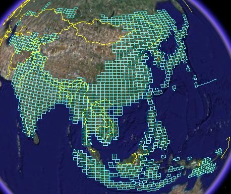
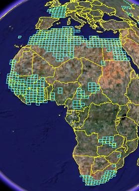
An earlier post featured a Google Earth KML file by Price Collins that indexed US Army topographic maps (1:250K) downloadable from the Perry-Castaneda Map library. At that time, 435 city maps and 413 1:250K quadrangles had been indexed, with each indexed map reference in the KML file containing a download link to the original map graphic file. Price writes to say that he has finished the index; it now includes 1785 topo quadrangles, covering large parts of Asia, Oceania, and Africa:

2rcr49y

5fnjew

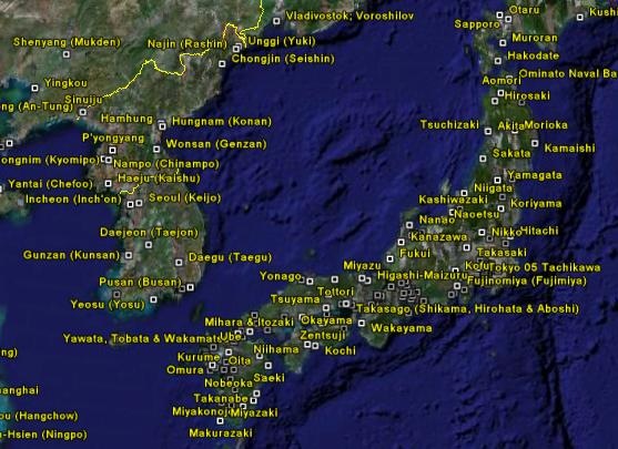
Also, 440 city maps; this picture shows those available for part of East Asia

2ci7l7n


Stamping Geotagged Photos With XMP Location And Coordinates

4/26/09: GPStamper is now a commercial program; there’s a trial version that runs for 30 days, and free versions are available for non-commercial scientific work and surveys.

I posted earlier on GPStamper, a handy free utility that takes a geotagged photo and prints the coordinates and time it was taken at on the bottom of the image, saving a copy of it losslessly (no degradation of the original JPG image), leaving the original image untouched. Mike Lee, the author of GPStamper, writes to say that he’s upgraded the program with a few new features:

Continue reading ‘Stamping Geotagged Photos With XMP Location And Coordinates’


Additional ERDAS Viewfinder Utilities

While a previous post dealt with using ERDAS Viewfinder to re-project raster images from one coordinate system to another, probably its most useful function, it does also have some other utilities. To start with, it has some satellite image viewing and enhancement capabilities, including multiband display, sharpening and softening, histogram equalization, and two standard deviation stretch. I won’t talk about those here, since I think its capabilities in that area are too limited to be especially useful, and I’ll probably cover more useful satellite image analysis programs in the future, But if you’re interested in those, you can take a look in the help file, or this handy tutorial PDF, which also describes how to use the general toolbar controls to zoom in/out and pan the map.

Instead, I’ll look at two other utilities, accessible from the Tools menu:

Continue reading ‘Additional ERDAS Viewfinder Utilities’


Reprojecting Raster Imagery II – ERDAS Viewfinder

For a long time, I thought that the free utility ERDAS Viewfinder 2.1 had slipped through the cracks after the acquisition of ERDAS by Leica Geosystems, but it recently re-surfaced for me in a Google search. And that’s great (thanks, Leica!), because while Viewfinder is an OK geographic image viewer, especially when compared to the many alternatives now available, it does have one very handy capability: the ability to re-project a raster image from one coordinate system to another, and save the new image in GeoTiff format with the new projection/datum data embedded.

Continue reading ‘Reprojecting Raster Imagery II – ERDAS Viewfinder’


Simple Online Form For Creating An Embeddable Google Map

GEarthHacks has a new online tool called YourMap that simplifies the job of creating embeddable Google Maps. Enter the name, address (or lat/long), zoom level, desired map dimensions, and other information into an online form, and YourMap automatically generates the code to embed it in your website; you don’t even need your own Google Maps API key. Here’s an example for a great hole-in-the-wall Thai restaurant in Flagstaff, AZ:

View in Google Earth — Download Google Earth
Powered by YourMap from Google Earth Hacks.

Via All Points Blog.

Addendum: Just noticed that the location plotted above for the restaurant about 500 yards south of the actual location. Double-checked the address used for geocoding, and it was entered correctly, so you may want to check the results of YourMap’s geocoder to make sure it’s right.


Reprojecting Raster Imagery I

There’s no really complete free substitute for a good commercial program like Global Mapper or FME for reprojecting raster images from one coordinate system to another. Not only do they support virtually every projection and image format, but they also have batch conversion capabilities for converting many images in a single step. But they’re expensive, and overkill if you only have a small number of basic conversions you want to do; for those basic needs, there are some simple and free alternatives.

MicroDEM – I’ve covered the use of MicroDEM before for converting graphic files with worldfiles into GeoTiffs with both georeferencing and coordinate system data embedded. But you can also use it to convert GeoTiffs in the NAD27 datum to the program’s native WGS84 projection using essentially the same process: open the NAD27 GeoTiff, zoom it to 1:1, and then export it as a GeoTiff in WGS84 (read the original post for more info). That’s all it does, change the datum – it maintains the projection of the original (i.e. if you start with UTM or geographic, the two projections it supports, that’s what you’ll wind up with). And it converts indexed color files to RGB, making the filesize lot larger. But for the common need to convert USGS topo maps from NAD27, like those freely available from Libremap or other sources, to WGS84, it may be enough for some people.

gdalwarp – Part of the GDAL library (included in FWTools), this command-line raster re-projection utility is extremely powerful, but its command-line nature makes it less than user-friendly, and learning the proper codes and syntax for converting from one coordinate system to another isn’t my idea of fun. If you have one conversion you do on a regular basis, setting up a batch file might make that process a bit easier, but a graphical user interface would be even better. Note to command-line fans: Yes, I’m a wimp.

MapWindow – I include MapWindow because, not coincidentally, it does include a graphic interface to gdalwarp that supports many projections/datums, and which also appears to have a limited batch processing capability. Access it using the GIS Tools => Image => Reproject Images menu function (make sure GIS Tools is enabled in the Plugins menu). The image file and coordinate system selections (source and target) are straightforward. The one problem is … I haven’t been able to get it to work on my system. After going through the whole process, I keep getting an error message saying that image export through GDAL isn’t supported. But I’m guessing this will be fixed reasonably soon, and as a bonus, MapWindow also comes with a really nice shapefile coordinate system converter.

But until MapWindow is functional, I’ve found another free program that re-projects georeferenced image files from one coordinate system to another, supports a fair number of datums and projections, and supports export in indexed color format. More on that in the next post.


Downloadable US Bathymetric And Fishing Maps

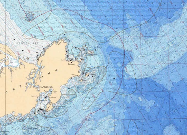
The National Geophysical Data Center has downloadable bathymetric and fishing maps for most of the US ocean coastline (not intended for navigation purposes, though). Map catalogs are broken down by geographic region, and maps are available in both small PDF preview format and large format downloads in either PDF or TIF format (the latter in gz compression, which will require an unzipping program like WinZip or ZipGenius). If you need the PDF maps in a editable graphic format, you can use a program like PDFCreator to “print” the PDF maps in full-resolution TIFF, JPG, or PNG formats. Maps are also not georeferenced (not GeoTiffs or GeoPDFs); I hope to cover some basic georeferencing options soon.

capeann

The full sets of data available from the NGDC include more bathymetric and relief data, geology/geophysical data, and earthquake/volcano data.