blankblank blank


Archive for the 'Web apps' Category Page 5 of 10


Geographic Polling Website SurveyMapper Now Live For The United States

The Centre for Advanced Spatial Analysis, University College London’s SurveyMapper site has been live for the United Kingdom for a while now, but just added the ability to do geographic-based survey polls for the United States as well as Europe and the entire world. The process for creating a survey couldn’t be easier. After free registration, click the “Create Survey” button; the first page will ask for basic info:

Continue reading ‘Geographic Polling Website SurveyMapper Now Live For The United States’


Personal Web Maps With StepMaps

StepMap lets you create distinctive personalized maps that you can save as an image, or embed on a web page. A step-by-step wizard walks you through the process.

Step 1: Choose a preset region and map style, modify the style as you wish, or upload your own map:
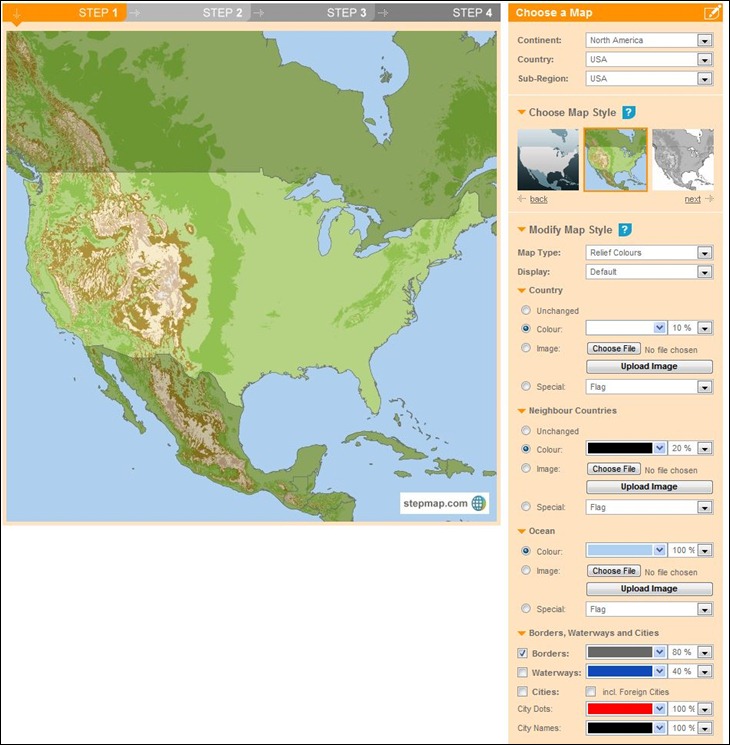
stepmap1

Step 2: Add points/icons, and connecting lines between points if you want. Click on the map to add a point; you don’t need to be exact in the positioning, as StepMap lets you automatically georeference the location based on its name.
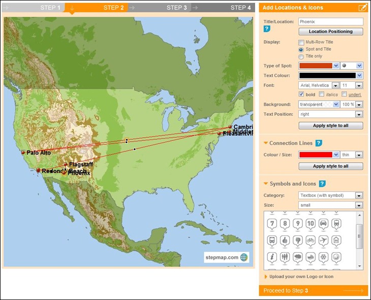
stepmap2

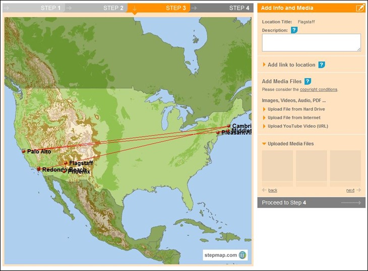
Step 3: You can optionally upload media files (picture, video, audio, documents) and link them to locations, or just link web addresses to them:
stepmap3

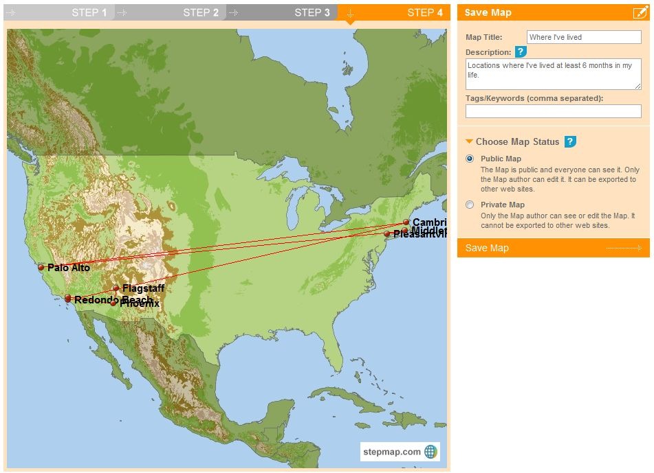
Step 4: Give the map a title//description/tags, then save it ( you have to add all three, even if you don’t want to):
stepmap4

Once saved, you can print out the map right away, save it as an image, link to a map page, or embed it on your website using provided HTML code:

Where I've lived
Create a Map with StepMap

StepMap

Where I've lived

One advantage of embedding the map code rather than just the image is that if you later modify the map, the changes will automatically be reflected in the embedded map.

Basic functionality is completely free for private, non-commercial and education use, and some commercial use is free as well; consult the Terms Of Use table to see what usage is allowed, and also what you can get by subscribing to the paid service.

Via La Cartoteca.


Where Americans Are Moving

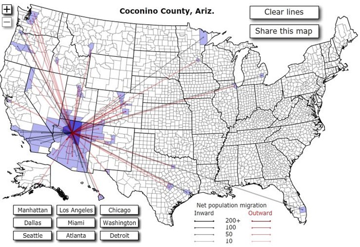
Forbes Magazine has an interactive US map showing migration patterns between counties in the US for the year 2008.
Click on a county, and lines connect that county to other counties where 10 or more people have either moved to that county (black lines) or away from that county (red lines):

migrationmap

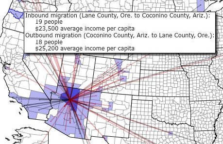
Mouse over a colored county to see the inward/outward numbers, and average per-capita income in both counties:

fullscreenmap

At least 10 people have to move in or out of a county for data to show up.

Via Kevin Drum’s blog.


Online Elevation Profiler

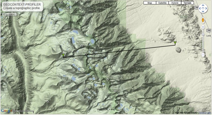
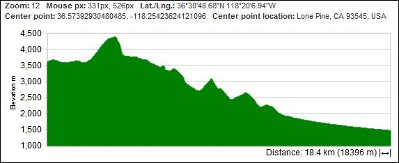
Krystian Pietruszka emails about his new Geocontext Profiler site, based on the new Google Maps API version 3. Place two markers on a Google Maps view by clicking, and get the elevation profile between them:

geocontext

geoprofile

You can add as many additional markers as you want in any direction; to fine-tune a marker position, just click and hold on it, and drag it to the desired spot. You have multiple options for the lines between points:

  • Direct – Straight line between points
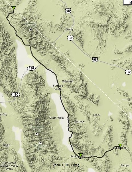
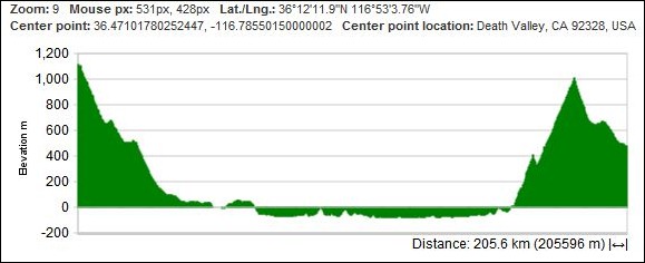
  • Driving – Elevation along roads from point to point (like this preset example for Death Valley):

deathvalley

deathvalleyprofile

  • Bicycling/walking

Click on the Geolocation IP link at right to jump to your local area; click on the double-arrow icon in the upper right corner to go to full-screen-width for the app (and back again). You can also link to a profile, or embed it on your site:

Note: The “Import KML” link in the upper left of the map will let you load and display KML data on the map, but doesn’t create an elevation profile between points or along a line.


TopOSM – An Open Street Map Based Topographic Map

I’ve been checking in on Lars Ahlzen’s TopOSM site occasionally for a while now; he’s had a web-based map server with really nice Open-Street-Map-based topographic maps for Massachusetts and Colorado for a while now, but there hadn’t been any new additions for a while. Via the Mapperz blog, I see that there’s been a major addition in the past few months, with data added for the Western US (California, Nevada, Oregon and Washington). These are really nice-looking maps, with relief-shaded terrain, contour lines and road/trail data from the OSM project; starting view is centered around San Francisco:

Continue reading ‘TopOSM – An Open Street Map Based Topographic Map’


ArcGIS.Com Goes Into Beta

Lots of post on numerous blogs in the past few days about ESRI’s ArcGIS.com site coming online in beta format. From the help file:

  • Tools for building interactive maps
  • Maps and applications from the Web and GIS communities
  • Basemaps and specialty layers from ESRI
  • Developer resources for building Web mapping applications
  • Storage space for your map and application resources
  • Communities for sharing geographic information
  • Easy-to-use search for quickly finding what you want
  • Ranking and rating system for shared maps and applications

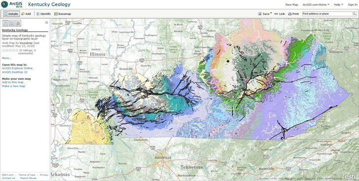
Requires an ESRI Global Account to save maps and upload data (free); even if you have a GA, you may have to register for a new one, as it wouldn’t take my old account info. Creating a basic map is pretty simple – choose a background map and a data layer:

kygeology

In my ignorance, I was hoping for a full free online GIS experience, like the GISCloud app I posted about a few weeks ago, and this isn’t it. For online data sources, you’re limited to either ArcGIS Server, Web mapping services, or mobile apps. For your own data, you’re limited to data packages created by ArcGIS products, like map packages (mpk) or layer packages (lpk). If you don’t have ArcGIS, you’re out of luck – no raw data files like shapefiles or raster imagery accepted as content. That isn’t a slam – it just means that I’m not the intended target, an ESRI product owner who wants to develop web/mobile mapping sites and applications. If you are, this site is very definitely worth exploring. Of note for app developers, there are APIs for Javascript, Flex, Silverlight, iPhone and Windows Mobile. For more info, I’d recommend a listen to the latest Very Spatial podcast; they have an interview with Bern Szukalski of ESRI about ArcGIS.com.

Addendum: James Fee has a far more comprehensive (and knowledgeable) overview than mine.


GISCloud – An Online Geographic Information System Application

I’ve been playing around a bit with GISCloud, a web-based GIS program. Looks interesting, and promising, but still has serious limitations. Feature set includes:

  • Raster and vector data display
  • Vector layer import and editing, including shapefiles, MapInfo, KML, tab-delimited and GPX
  • Built-in datafile coordinate reprojection; recognizes prj files, and lets you select the output coordinate system (including the one for your current project)
  • Advanced GIS analysis tools, including buffering, spatial selection by analysis, layer comparison (e.g. intersection), and area calculations.
  • Export vector data layers in shapefile, MapInfo, CSV or KML; this makes it a handy online format converter.
  • Share map editing with other users (or just publish it for viewing)
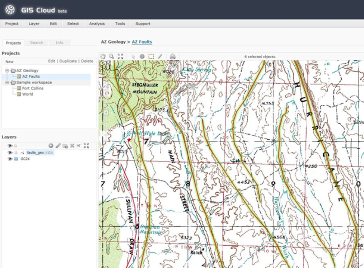
  • Easy-to-decode classic-looking GIS interface:

GISCloud

On the downside:

  • Only data layers imported into or through a PostGIS connection can be used for analysis and editing. I’m not up on PostGIS so I couldn’t test these functions, and none of the data sample sets have PostGIS data, either. You can apparently upload data and import it into a PostGIS database, though.
  • Uploading files can take a while (though they’re saved locally); GISCloud recognizes files in compressed archives, so you’re best off zipping up your data before you upload it.
  • For PostGIS data, I suspect that upload times are going to limit the size of the vector/database layers you can use.
  • Apparently no thematic (attribute-based) display colors yet; this is a major drawback.
  • Raster imagery updates during zooms can be slow.
  • Not all raster image types supported (e.g. 8-bit indexed GeoTiffs don’t work, 24-bit do).
  • It’s not exactly the zippiest GIS platform I’ve ever worked with.
  • It’s Flash-based, so Flash haters and iPad users should avoid, and everyone should expect CPU/performance/crashing issues. Flash 10.1 is supposed to be out soon, and supposedly will address some of those problems.

An interesting early effort in cloud-based GIS, and I’ll be watching its development. But unless you have access to, and/or experience with, PostGIS, of limited utility for now. And I don’t expect to see cloud-based GIS replacing dedicated GIS programs any time in the near future – too slow, and too limited.


WMS Inspector Extension For Firefox

Adria Mercador writes to announce his WMS Inspector Extension (WMS = Web Map Service) for the Firefox browser:

  • Load all WMS requests in the current page and their parameters
  • Requests sorting by service or type
  • Individual WMS requests (images or errors) visualization
  • Copy services, requests or parameters to the clipboard
  • Direct editing of requests parameter values
  • Output GetCapabilities response as an HTML report or original file

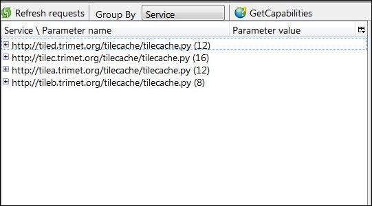
Control screen:

wmsinspector

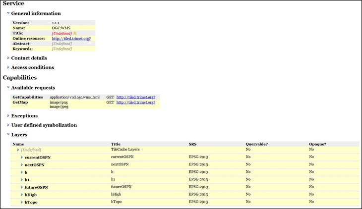
GetCapabilities output (HTML):

capabilities