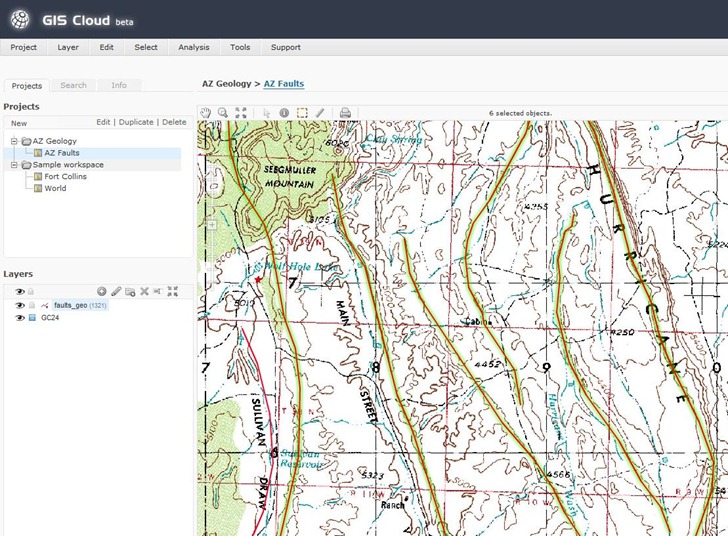
I’ve been playing around a bit with GISCloud, a web-based GIS program. Looks interesting, and promising, but still has serious limitations. Feature set includes:
- Raster and vector data display
- Vector layer import and editing, including shapefiles, MapInfo, KML, tab-delimited and GPX
- Built-in datafile coordinate reprojection; recognizes prj files, and lets you select the output coordinate system (including the one for your current project)
- Advanced GIS analysis tools, including buffering, spatial selection by analysis, layer comparison (e.g. intersection), and area calculations.
- Export vector data layers in shapefile, MapInfo, CSV or KML; this makes it a handy online format converter.
- Share map editing with other users (or just publish it for viewing)
- Easy-to-decode classic-looking GIS interface:

On the downside:
- Only data layers imported into or through a PostGIS connection can be used for analysis and editing. I’m not up on PostGIS so I couldn’t test these functions, and none of the data sample sets have PostGIS data, either. You can apparently upload data and import it into a PostGIS database, though.
- Uploading files can take a while (though they’re saved locally); GISCloud recognizes files in compressed archives, so you’re best off zipping up your data before you upload it.
- For PostGIS data, I suspect that upload times are going to limit the size of the vector/database layers you can use.
- Apparently no thematic (attribute-based) display colors yet; this is a major drawback.
- Raster imagery updates during zooms can be slow.
- Not all raster image types supported (e.g. 8-bit indexed GeoTiffs don’t work, 24-bit do).
- It’s not exactly the zippiest GIS platform I’ve ever worked with.
- It’s Flash-based, so Flash haters and iPad users should avoid, and everyone should expect CPU/performance/crashing issues. Flash 10.1 is supposed to be out soon, and supposedly will address some of those problems.
An interesting early effort in cloud-based GIS, and I’ll be watching its development. But unless you have access to, and/or experience with, PostGIS, of limited utility for now. And I don’t expect to see cloud-based GIS replacing dedicated GIS programs any time in the near future – too slow, and too limited.
Thanks Leszek for the review!
Also thanks for pointing out pros and especially cons. Feedback is what moves us forward.
I’ll just comment few things on the cons list of course :)
– GIS Cloud is currently located on our servers in Europe. This fact makes still a small, but probably noticeable, delay when user is located in States or in Asia. We plan to move to other cloud based providers, probably Amazon, so “slowness” issue will be resolved in that way. For best possible connection we plan to have data centers in all Amazon regions that are available.
– PostGIS is used as a back-end database because it is quite robust and powerful. We don’t plan to offer direct access to it (maybe as an advanced option), rather we are trying to encapsulate as much of its functionality through easy-to-use wizards and tools. This is why we are depending on it for analysis.
– Editing is for now only available for PostGIS sources, we are planning to add support for editing any format directly
– Regarding uploading this depends on the connection. What we plan to do here is to add a way to download any file or dataset from internet directly to GIS Cloud. So you wouldn’t have to download it locally and then again upload it. As we plan to move to Amazon, they have Import/Export service which can be ideal for large datasets: http://aws.amazon.com/importexport/
– Thematic maps are supported. It is possible to define expression in layer definition and define styling for each: http://www.giscloud.com/about/docs/eng/documentation/creating_a_new_gis_project/layers_panel/
– We will work on better raster support
– About Flash :) I can understand that some like it and some hate it. This is the endless debate. But the fact is that it is currently best and most available vector rendering engine. As we want to keep desktop GIS performance our map engine is based on it. The rest of application is standard HTML, CSS, AJAX. In the (near) future we plan to provide a parallel vector based map engine based on HTML5 and SVG support. This will make GIS Cloud available in all modern web browsers (including iPad and iPhone) without a need for Flash.
Thanks again for the article and feedback!
Best,
Dino Ravnic