blankblank blank


Archive for the 'GPS' Category Page 17 of 25


Stamping Geotagged Photos With XMP Location And Coordinates

4/26/09: GPStamper is now a commercial program; there’s a trial version that runs for 30 days, and free versions are available for non-commercial scientific work and surveys.

I posted earlier on GPStamper, a handy free utility that takes a geotagged photo and prints the coordinates and time it was taken at on the bottom of the image, saving a copy of it losslessly (no degradation of the original JPG image), leaving the original image untouched. Mike Lee, the author of GPStamper, writes to say that he’s upgraded the program with a few new features:

Continue reading ‘Stamping Geotagged Photos With XMP Location And Coordinates’


Six Free Must-Have Applications For Your Handheld GPS

The logs for this blog indicate a lot of visitors have come by recently looking for information on using handheld GPS units (Christmas gifts, perhaps?). So for those newcomers, I thought I’d do a quick roundup of the free applications I’ve found to be among the best for a variety of handheld-GPS-related tasks, along with some worthy alternatives that also have something to offer. Most are Windows-only, but a few are also available in native format for Mac and Linux, and may well run in Mac under Parallels/Boot Camp and Linux under WINE.

Downloading/uploading point and track information

While most handheld GPS units let you create waypoints, routes and sometimes tracks directly, their small size and limited input options can make this difficult and time-consuming. These programs speed up and simplify that process tremendously.

Best: GPS TrackMaker

While I use this program mainly for downloading and uploading data files in a variety of formats (GPX, KML, SHP, MMC and more), the program has many more useful options for creating waypoints and tracks, simplifying existing tracks, altitude profiles, even interfaces for working with Google Earth and Google Maps. Supports 160 different GPS models. More info.

Worthy alternative: EasyGPS

GPS TrackMaker has lots of features, but that can make the interface a bit cluttered. If you’re only interested in working with GPX or LOC files, EasyGPS is a clean, simple alternative that also supports GPS models from a wide range of manufacturers. More info.

GPS datafile creation with maps

If you want to create waypoints and routes by drawing them directly on a map, here are some options.

Best: USAPhotoMaps

USAPhotoMaps downloads USGS topo data, and one-meter black and white aerial imagery for the entire United Sates (0.25-meter color aerial imagery for some urban areas), and lets you create highly-accurate waypoints for export to a GPS unit. Route and track support, on the other hand, are pretty weak. More info.

Worthy alternative: You can always create points and tracks in Google Earth for export to a GPS (see below), or use an online service like TakItWithMe (more info) Digipoint 2 (more info) or quikmaps (more info) to take data created in a Google Maps interface to GPX format. But be aware that positions in Google Earth or Google Maps can be off slightly from their true position.

GPS file format conversion

There are dozens of formats for saving geographical data, but most GPS utilities only support a few of them. So it’s handy to have software that will convert from your obscure and bizarre format to one in more common use.

Best: GPSBabel

GPSBabel is the sine qua non of GPS format converters, handling more different formats than any other program I know. It’s a command line program, but comes with a GUI that, while not fully user-friendly allows reasonably easy access to most of its conversion capabilities. More info.

Worthy alternative: ITNConv

ITNConv handles a few formats that GPSBabel doesn’t, and also allows editing/creation of GPS data files in a Google Maps interface. More info.

Digital globe

Best: Google Earth

You probably already have Google Earth installed on your computer for general geographic browsing and exploration. But you may not know that in addition to its native data formats of KML/KMZ, Google Earth can also directly open GPX and LOC data files exported from your GPS, so you can see where you’ve been. If you want to connect your GPS directly to Google Earth, you could pay $20/year for Google Earth Plus, but I have a series of posts on getting Google Earth Plus features for free, along with some features GE+ doesn’t support, like exporting data from Google Earth to your GPS.

Worthy alternative: WorldWind

WorldWind was one of the earliest digital globes, and open source if that’s important to you. In some ways, it’s superior to Google Earth in its support of GPS, with built-in support for real-time GPS positioning in the main version. The free GPS2WorldWind plugin adds extensive support for importing and exporting data from/to Garmin GPS units, and limited support for other units through the NMEA interface.

Photo geotagging

Geotagging refers to embedding location data into the header of picture files, so that you can associate the picture with the location it was taken. Many free programs will do this automatically by matching a photo’s timestamp to the time you were at that location according to your exported GPS data. Geotagged photos can then automatically be displayed in a map program at the location they were taken; for example, Picasa can take geotagged photos and convert them into a KML file for display in Google Earth.

Best: GeoSetter

I’ve covered a fair number of photo geotagging tools on this blog (see the series listing at the end of the above post), but GeoSetter has the best mix of features and usability of any of them. More info.

Worthy alternative: GPicSync

Although it lacks some of GeoSetter’s features, GPicSync has a simpler interface that might appeal to some, and has some features that GeoSetter lacks. For example, you can associate audio and video files with the pictures, so that GPicSync will create links in the Google Earth / Google Maps files that link to the audio/video. More info.

GPS satellite visibility

The accuracy with which your GPS unit can determine your position depends partially on the number of satellites visible in the sky from your location, and also their geometry, i.e. how widely spaced apart in the sky they are. The more satellites there are, and the more widely-spaced they are in the sky, the more accurate your GPS-determined position will be. While most GPS units will give you a rough estimate of how accurate the current position it’s giving you is, they won’t tell you when during the course of a day you can expect to get the best (or worst) accuracy. For that info, try this program:

Best: Trimble Planning

Trimble Planning will calculate the relative degree of geometry-dependent accuracy for a specific location, and how it changes with time, presenting this data in easy-to-interpret graphic and tabular formats. A more detailed description of the program can be found here; more advanced users might want to take a look at my post on how to incorporate the effects of GPS satellite blockage by terrain on these accuracy calculations.

Worthy alternative: Live Satellites Google Earth UI (no longer available)
I used to link to Paul Seabury’s Live Satellites Google Earth UI, but that application has been pulled. Orbiting Frog has a similar application that is a bit more difficult to use, since you have to manually enter satellite parameters, but it’s still worth a look; see this post at the Google Earth blog for more info.

Looking for a GPS application that isn’t listed above? Try doing a search on this blog – I’ve covered dozens of different GPS applications in addition to the ones I’ve highlighted above.


Real-Time GPS/WAAS Status Reports

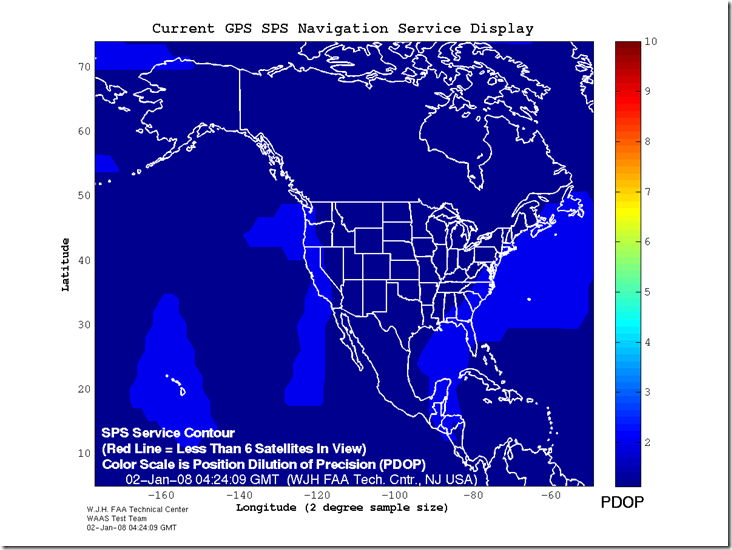
Not too long ago, I posted about a site that offers maps of GPS Dilution of Precision (DOP) for the US and the world for the next three days. The FAA’s WAAS test team has a website that offers both similar and complementary data. In addition to having maximum DOP maps for the current day, similar to the other site, it has real-time maps of the current DOP across the US:

SPS_big

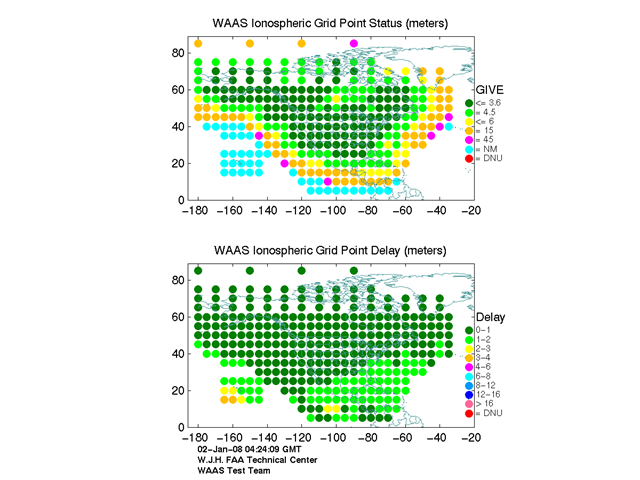
The actual delay in GPS signal due to ionospheric conditions:

igp_plot

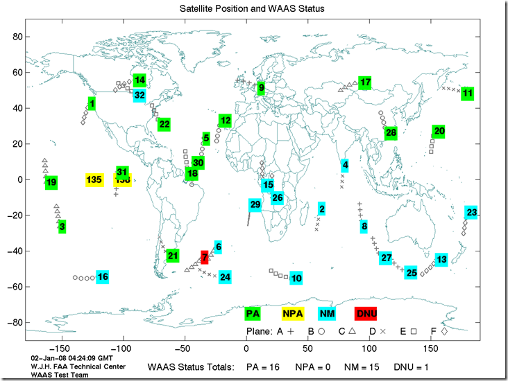
And the current real-time positions of all GPS/WAAS satellites above the earth, along with their status:

waas_sats

Along with many other GPS-related graphics and technical reports as well.


GeoSetter: The Best Free Photo Geotagging App?

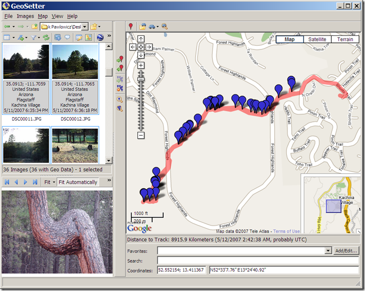
I’ve posted about a fair number of applications for geotagging photographs, embedding the geographic location into the photo’s EXIF header either manually or by synchronizing the time the photographs were taken with a GPS GPX track file. So far, my favorites have been GPicSync and Location Stamper, but GeoSetter is my new program of choice. Among its features are:

  • A convenient and easy to use photo album display and Google Maps interface

11-24-2007-8.02.08 PM11-24-2007-8.03.14 PM12-15-2007-10.51.10 PM

  • Automated geotagging of photos with a GPX, NMEA, PLT or Sony LOG track, with adjustable time zone and time matching tolerance
  • Synchronize untagged photos with geotagged photos taken at the same time/place
  • Display of the track and position markers for the photo in a Google Maps window
  • Automatic retrieval of the geographic location of a photo (e.g. the name of the nearest city, state and country) for embedding in the photo’s IPTC header
  • The ability to manually edit the photo’s header, including not just the geographic data, but also the IPTC source/description, category/keywords, etc.
  • You can also manually geotag a photo by creating a marker in the Google Maps interface, then associating that marker with the photo
  • Export of selected photos to a Google Earth KML file, with or without the track file. While other programs have this capability, GeoSetter lets you also export your choice of any of the EXIF/IPTC header data associated with the photo to the KML file as well.
  • Undo/Redo capability
  • Eight different languages
  • Unlike some of the other programs I’ve posted about, GeoSetter’s geotagging is recognized by Picasa

The biggest flaw with the program is the lack of a help file (a few functions are documented on the website), but the program is so easy to use, you won’t miss it that much.

Thanks to Robert Kluszczynski for letting me know about GeoSetter.


GPS "Dilution Of Precision" (DOP) Maps

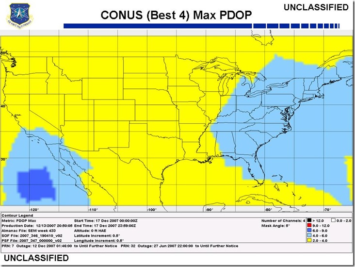
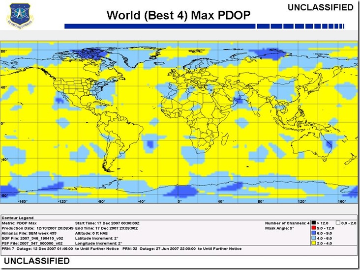
One of the principal factors affecting GPS accuracy is the satellite geometry, or how far apart in the sky are the visible GPS satellites. If spaced widely across the sky, you can get a more accurate determination of your position by trilateration than if they are “clumped” together. A measure of this geometric accuracy factor is the Dilution of Precision, or DOP; the lower the DOP, the more accurate your GPS position is likely to be (though there are many other factors that affect GPS accuracy beyond satellite geometry). Some more expensive GPS receivers can calculate and display DOP in the field, but most consumer-grade units don’t explicitly give the DOP, but factor it into their error estimates.

I’ve posted before about free programs from Trimble and Magellan that will calculate the DOP for any location at any time, and plot it over the course of a single day. But if all you want is a general indication of what the worst DOP at a specific location over the course of a day will be, or what it was in the past, the US Air Force’s GPS Operations Center publishes maps of both the continental United States and the world showing what the highest DOP (corresponding to the lowest accuracy) will be over a specified 24-hour period (click on the Performance Reports link near the top).

uclas_conus_dop

uclas_world_dop

The default map is for three days in the future, which is also the latest date available. But you can get maps for previous days, and one/two days in the future, in the Archived Reports section. The site also offers advisories about the current status of the GPS system, a FAQ, and useful links.


Google Maps Search Interface For Garmin .img Maps

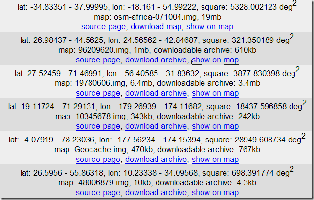
In a previous post, I listed off a few sources of free .img maps that can be uploaded to a Garmin GPS unit; GPS Tracklog recently posted a few more as well. There’s a new site called GPS MapSearch that makes the process of locating these maps a lot easier, using a Google Maps interface. Click on a point in Google Maps, and a list of Garmin-compatible .img maps for that area will appear in the right text box:

11-24-2007-8.02.08 PM11-24-2007-8.03.14 PM12-14-2007-8.37.54 AM

listing the geographic extents, with links to the original web page and the downloadable map file. Click on “show on map”, and the extents covered by that particular map will be displayed in the Google Maps interface:

11-24-2007-8.02.08 PM11-24-2007-8.03.14 PM12-14-2007-8.41.02 AM

Area coverage, level of detail, and quality of data are likely to vary widely, and it looks like some of the maps sources listed above aren’t included (the author is soliciting that data, so that may change). But it’s still a really nice tool to have, especially if you’re looking for Garmin .img maps in areas that aren’t covered by commercial products. Once you have a .img map, you can easily add it to your MapSource dropdown list using Mapset Toolkit.


Creating GPS Routes And Tracks In Google Earth

EarthNC has a new Google Earth tool for taking points, paths, and polygons created in Google Earth, and either converting them to GPX or uploading them directly to a Garmin GPS (Windows only for the latter). Points are converted to points, paths to routes, and polygons to tracks. The downloadable KML file, full text instructions, and a demonstration video, are available at the website. They also have a simple online tool for converting KML files directly to GPX format by copying the KML file into the online text box and clicking a conversion button.

Via Ogle Earth.


Beta Version Of DNRGarmin

One of the first posts on this blog was about the 5.1.1 stable version of DNRGarmin. Long story short, if you work with GIS and you use Garmin units for your data acquisition, this program is a must-have. It can upload/download data in text, DBF and shapefile formats to/from Garmin GPS units, and also comes with an extension for direct interfacing with ArcGIS software. Version 5.1.1 had some utility for non-Garmin GPS units and applications, but version 5.2, currently in beta, has some new features that make it a worthwhile installation for anyone with a GPS.

DNRGarmin has actually been in beta for a while, and I’d been waiting to see if it would come out of beta; the date on the last release is 5/18/07. The webpage indicates in big bold letters that in the beta, “THE ERROR RELATED TO USB CONNECTIVITY AND LOGIN RIGHTS HAS NOT YET BEEN RESOLVED“. But I’ve installed it successfully on 3 different computers without encountering this problem, so there’s a decent chance it should work on yours as well.

New features in version 5.2 include:

  • Load data in KML and GPX (in addition to the previous options of text, DBF and shapefile formats)
  • Load data directly from the “My Place” pane in Google Earth
  • Save data in KML and GPX (along with the previous options of projected/unprojected shapefiles, text and DBF)
  • Convert between the different formats
  • Collects waypoint time data from supported units

Note: The new version’s ArcGIS extension no longer works with ArcGIS 8.x, only 9.x. If that’s important to you, you should stick with version 8.1.1, still available on the web page. But the new version works fine in stand-alone mode.