blankblank blank


Archive for the 'GPS' Category Page 18 of 25


Sources For Free Garmin .img GPS Map Files

As mentioned in the previous post, you can use MapSet Toolkit to add any .img Garmin map file to MapSource. If you want to try out the process on some free .img files, here are some sources for .img files, as well as some data in executable files that install it automatically in MapSource without the need for MapSet Toolkit:

  • Mkgmap wiki: .img files for the UK, South Africa, and Africa
  • OpenStreetMap wiki: Files for Germany/Netherlands and the entire world (read the caution for the latter, though; it might crash MapSource if you install it there)
  • GPS Vector Map Morocco has Garmin maps for Morocco and Western Sahara.
  • Yunnan Explorer has some topographic maps for areas of Yunnan Province in China.
  • cgpsMapper MapCenter (and MapCenter2): Maps from around the world, browsable by country and type. Coverage is hit-and-miss, but for some countries it’s very good. For example, the New Zealand Open GPS Project is creating road maps for the entire country as a complete set with an installer that puts them automatically into MapSource.
  • Tracks4Australia has installable map tiles for all of Australia.
  • The GPS Maps site has downloadable maps for Garmin mapping GPS units. Levels of detail included are mixed, but the maps can include topographic contours, land details, and road maps in various levels of detail (either VMAP0 or VMAP1). Areas covered:
    • The Caribbean (including Cuba and parts of South Florida, Central and South America)
    • Bermuda
    • Japan
    • Antarctica
  • Greece GPS Maps has … maps of Greece.
  • And one of these days, I’ll get around to posting on some of the free options for creating your own .img files …


Adding Garmin .img Map Files To MapSource

8/29/09: Some have reported issues with the latest versions of both cgpsmapper (0098c) and MapSet Toolkit (1.62). If you have a problem with these, try using older versions of both programs, available at this link. Also, if you have problems with installing a mapset, try right-clicking on the program and choosing “Run As Administrator”; Windows crappy security system sometimes blocks programs from modifying the Windows registry, which MapSet Toolkit needs to do to install a mapset.

In the last post, OpenStreetMap data was converted to a Garmin .img map file, which can be directly uploaded to a Garmin GPS unit using SendMap or MapUpload software. But it’s more convenient to use the MapSource software that comes with most Garmin GPS units to do this, since you can preview the map data in that program, and create/upload multiple maps and mapsets easily. The best program I’ve found to do this is MapSet Toolkit; you’ll also need the map compiling program cgpsmapper, free for creating basic maps for personal use.

Using the process in the previous post, I downloaded some street data for London, and converted it to a Garmin .img file. I then used the following steps to add the .img file to MapSource:

1. Created a subdirectory in my C:\Garmin directory called “London”, and copied my “63240001.img” file there. Note: MapSet Toolkit will only recognize .img files with a numerical filename. If you rename the file with a non-numerical name, it won’t show up.

2. In Mapset Toolkit, chose that file with “Select IMG files”.

3. Highlighted that file, and “Add”ed it to the selected IMG files. You can add multiple .img files as part of a single set of files.

4.Chose the same directory that contained the .img file as the “Mapset directory” to be used

5. Assigned a name to the mapset, “London”

6. Chose a 4-digit “Product Code” number (“8765” in this example); the only limitation is that it not conflict with any other product codes (which are displayed in the “Uninstall Mapset” box at the right).

7. You can enter copyright info if appropriate, but it’s not required here

8. At lower left, chose the directory where cgpsmapper.exe is located (usually the C:\Program Files\cGPSmapper directory), and selected the cgpsmapper.exe file

9. The “Convert (Product>Families)” section was left blank; more information about Family ID and TYP files is available in the cgpsmapper manual.

10. Checked the box marked “Install in MapSource”. Checking “Blank overview maps” will eliminate the map preview in MapSource. I’ve found that for some mapsets, leaving this box unchecked will result in a crash of cgpsmapper, and a failure of the installation; in that case, check the box and try again.

11. Clicked “Start”, and shortly thereafter got a message box saying “Convert termined” (sic).

12. In the “Uninstall Mapset” section, there’s now a new listing for the added map.

The program screen after all these operations looks like this:
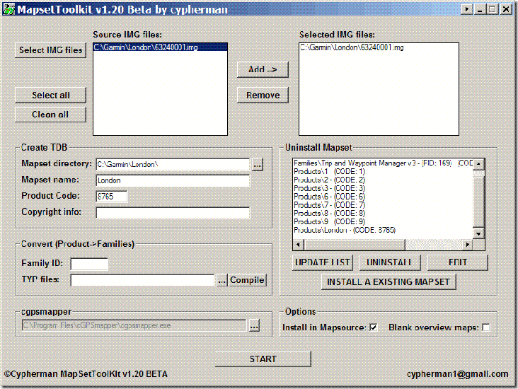
Mapset Toolkit

If I now open Mapsource, the dropdown at the upper left has a selection for “London”; selecting it brings up the OpenStreetMap data:
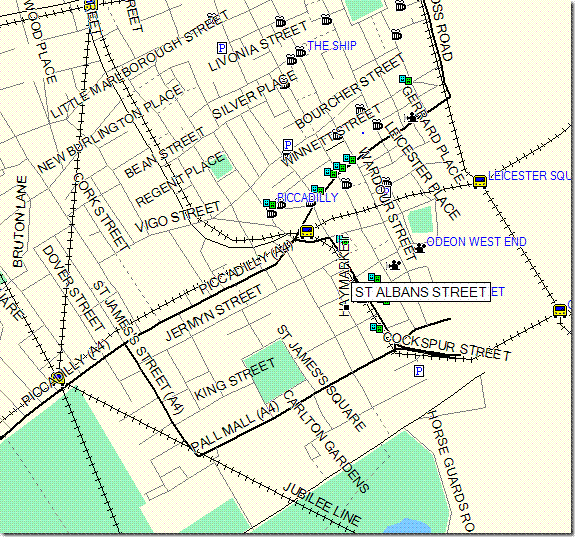
Londonmap

I can now select this dataset along with any others I might want, and upload it to my Garmin.

You can also use the “Uninstall Mapset” section to remove mapsets from MapSource as well. Occasionally, installing a mapset will cause problems with MapSource starting up; usually, uninstalling the mapset with MapSet Toolkit will fix that problem. You may have to run the program in “Administrator” mode to get this to work (see the comments below).

There’s more complete documentation available in PDF format at the MapSet Toolkit website. And a more complete, technical tutorial on doing this is available at the GPSFileDepot.

Addendum: There are two other programs floating around that can also add .img files to MapSource. M3 is available at MalsingMaps.com, where you can also find free Garmin maps for Borneo, Malaysia and Singapore; free registration required. However, I’ve found that if you install a MapSet using M3, other mapsets installed by either MapSet Toolkit or with the Garmin installer can disappear off of the dropdown menu (they come back after you uninstall the offending mapset). GPS Map Manager is better than M3, but MapSet Toolkit has a better interface and more capabilities.


Converting A Garmin USB GPS Connection To Multiple Serial NMEA Connections

Many GPS-related programs require an NMEA connection to your GPS through a serial port. But many new computers don’t include a serial port anymore, while many new GPS models, particularly Garmin, only have a proprietary USB interface and not a serial NMEA interface. For computers that don’t have a serial port, you can always buy a USB to serial converter like those from Keyspan. And for Garmin USB-only GPS units, there’s a program called GPSGate from Franson that converts the USB connection to multiple virtual serial NMEA ports, $10-30 depending on how many ports you need. Garmin offers a similar program for free called “Spanner” for their GPS 18 model, a USB receiver/antenna that’s designed to plug in to a notebook’s USB port and interface with programs running on it. What Garmin doesn’t say is that “Spanner” will also work with some, albeit not all, of its other GPS receiver units; you’ll have to experiment to see if it works with your model. And even if your Garmin has both serial and USB interfaces, like my Garmin 60Cx, using this program can save you the expense of a GPS-to-serial cable, a USB to serial converter if your computer doesn’t have a serial port, or both. Note: Only works with XP; doesn’t work with Vista and Windows 7.

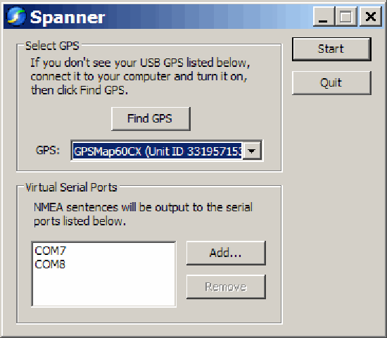
Download the Spanner program from the Garmin website, and install it. The program has only one configuration window:

Spanner

You need to have your GPS turned on, connected to your computer via USB, and using the Garmin protocol; if any of these isn’t true when you start Spanner, make it so, then click “Find GPS”. At the bottom, use the “Add” button to add a virtual serial port to your computer for use by your software as an NMEA connection. Make sure you choose a number for your COM port that doesn’t conflict with any your computer currently has. I believe that Windows can handle COM1 through COM 255, but keep in mind some software programs won’t support ports higher than COM8, or even COM4.

I’ve had two programs running simultaneously, each one getting NMEA data from a different COM port, and given that COM ports are pretty slow, I’d guess that you could add a few more without putting a serious strain on your computer’s resources.


Prune – Java-Based GPS Track Visualization And Photo GeoTagging

Prune is another Java-based GPS tool with its own unique set of features, including:

– Load multiple text, GPX or KML tracks, appending them to each other

– Trim duplicate points, and compress the track (hence the name Prune)

– Save combined tracks in text or KML format (use GPS TrackMaker to convert the KML tracks to GPX format if desired)

– See a plot of position, and altitude if available

Continue reading ‘Prune – Java-Based GPS Track Visualization And Photo GeoTagging’


Draw/Label On Google Maps, And Generate GPX/KML/Embeddable Maps

Not as useful as it was before Google Maps MyMaps came along, but quikmaps.com has many of the features that MyMaps does, and a few it doesn’t:

– Draw lines on a map, either with line segments or arbitrary freehand (no polygons, unlike MyMaps)

– Add points to the map using a larger variety of full-color icons than MyMaps

– Add text labels directly to the map (not in MyMaps)

– Embed the map and your content in your website

– Export the map data directly into either KML format or GPX format for downloading into your GPS


RouteConverter Updated

Just posted about RouteConverter, a Java-based GPS route/track manager, last Friday, and Christian has already updated it:

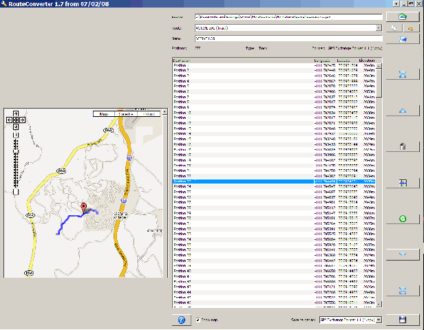
– The updated version for Java6 now includes a Google Map interface that displays the GPS track/route and the selected point position:

Capture3-26-2007-2.31.46 PM8-7-2007-9.51.17 AM

– There’s an executable for Windows, as well as a standard Java6 .JAR file for Windows and Linux

– A Java5 version with fewer features, but which is compatible with Macintosh, Windows and Linux


Java-Based GPS Route Format Converter

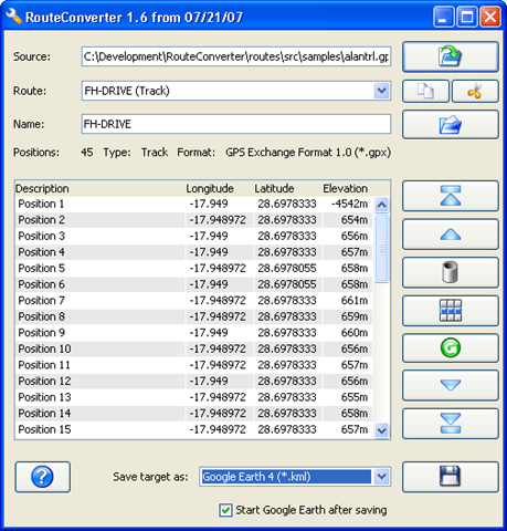
Christian Pesch has let me know about RouteConverter, his Java-based program for handling, editing and converting GPS routes. It requires Java 6, so it currently runs on Windows and Linux (no Mac). It lets you:

  • Convert between different GPS route formats; currently supports:
    • Garmin MapSource 5.x (*.mps)
    • Garmin MapSource 6.x (*.gdb)
    • Garmin PCX5 (*.wpt)
    • Google Earth 3 (*.kml and *.kmz)
    • Google Earth 4 (*.kml and *.kmz)
    • Google Maps URL
    • GPX XML 1.0 (*.gpx)
    • GPX XML 1.1 with Garmin Extensions (*.gpx)
    • Magellan MapSend (*.wpt)
    • Microsoft AutoRoute 2002-2006 (*.axe)
    • Motorrad Tourenplaner (*.bcr)
    • Navigon Mobile Navigator 4 (*.rte)
    • Navigon Mobile Navigator 6 (*.rte)
    • NMEA 0183 Sentences (*.nmea)
    • Tom Tom Route (*.itn)
    • Tom Tom POI (*.ov2)
    • Tour Exchange Format (*.tef)
  • Add/subtract/edit points in a route
  • Selects points within a certain distance of another point, and lets you delete them for route simplification
  • Append a route to the current route
  • Supports multiple routes within Google Earth, GPX and Garmin MapSource files

Screenshot (from the website):

image

A good supplement to ITNConv, since it handles multiple routes better than that program, is able to simplify routes, and also supports a few formats (NMEA, Tour Exchange) that ITNConv doesn’t. But ITNConv also handles some formats that RouteConverter doesn’t, and its Google-Maps-based editor for points is definitely a plus.


USAPhotoMaps: GPS Functions

USAPhotoMaps has built-in GPS interface capabilities for Garmin GPS units; it also supports the general NMEA GPS interface for other units. While there are a lot of GPS functions, they’re a mixed bag. Waypoint creation, export, and import on the fly are pretty easy (with some minor quirks), and USAPhotoMaps is my program of choice for quickly creating waypoints on a topo map or aerial imagery and then exporting them to my GPS unit. Saving and manipulating waypoint data is more problematical, and dealing with routes and tracks is a major headache. It seems as though some of these features were bolted on rather than integrated with the main program in a logical fashion. My experiences were with a Garmin GPS (60Cx); YMMV.

Continue reading ‘USAPhotoMaps: GPS Functions’