blankblank blank


Archive for the 'GPS' Category Page 15 of 25


Creating Custom Icons For Garmin Points Of Interest (POI)

Creating custom icons for Garmin POI files is similar to, but actually easier than, creating them for custom waypoints. I’ve covered the basic details of creating custom waypoint icons in two previous posts (part one and part two), and refer you to those for the general process. But the graphic format requirements are somewhat relaxed for custom POI icons compared to custom waypoint icons:

Continue reading ‘Creating Custom Icons For Garmin Points Of Interest (POI)’


Managing Custom POI Data On A Garmin Handheld GPS

So you’ve followed the directions in the previous post, and created a CSV POI file, and uploaded it to you Garmin GPS unit. Now what?

Continue reading ‘Managing Custom POI Data On A Garmin Handheld GPS’


Creating A Garmin Custom POI Datafile

In the first post of this series, I compared the features of custom POIs (Points Of Interest) and waypoints for a Garmin handheld GPS unit (like my 60Cx). This post will show how to create a POI datafile that can be uploaded into a Garmin GPSr.

Continue reading ‘Creating A Garmin Custom POI Datafile’


Introduction To Garmin GPS Custom POI (Points Of Interest) Data

“Waypoints”, geographic position markers created either in a GPS unit or using software, have been a function found on virtually every GPS unit ever made. More recently, “Points of Interest” or POIs have been implemented as an alternate way to store data for a point position, and many recent GPS units let you upload your own custom POI lists. POIs provide a handy way of organizing groups of points, and can also include more information on a point than a standard waypoint. I’ll be doing a short series of posts on creating and manipulating POIs. While the focus will be on Garmin GPS POI capabilities, other GPS manufacturers also support them as well, though usually in different formats. Note: As far as I know, only Garmin GPS units that use external data storage cards (like those listed in this post) can accept custom POI data.

Continue reading ‘Introduction To Garmin GPS Custom POI (Points Of Interest) Data’


Beating The Garmin 2025-Map Limit With US Topo Maps

Many recent Garmin GPS mapping units (like the 60Cx and 76Cx units) have a maximum limit of 2025 map sections that you can upload directly to the unit, and you’ll get an error message if you try to exceed the limit. If you try uploading more than 2025 to a microSD card in a card reader, you won’t get an error message, but the GPSr unit will still not be able to display the data from more than 2025 maps after you put the microSD card back into it. This wasn’t such a big deal when memory was expensive, and 128 MB of memory was considered a lot – there was no way you come close to that 2025 limit with that little memory. But these days you can get a 2 GB microSD card for a Garmin unit for less than $20, and you could easily fill such a card with more than 2025 maps if that were possible.

Continue reading ‘Beating The Garmin 2025-Map Limit With US Topo Maps’


A Look At OpenStreetMap's TIGER Data Exported To A Garmin GPS

Rich at GPS Tracklog cites OpenStreetMap’s recently-completed importation of the TIGER road data for the US, and challenges me to take a look at exporting it to a Garmin GPS (based on this post, I assume). OK, sure.

Continue reading ‘A Look At OpenStreetMap's TIGER Data Exported To A Garmin GPS’


Prune Updated: Now With Automated Photo Geotagging For Windows, Mac, And Linux

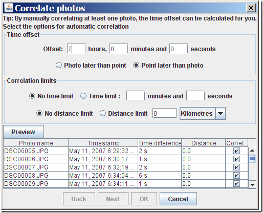
Prune is a Java-based GPS-track viewing and editing program that runs in Windows, Mac and Linux. When I last posted about it, the photo geotagging capability was a bit awkward – it required you to manually link a photo to a trackpoint, not automatically correlating trackpoints with photos based on time like most photo geotagging software. Version 4.1 is now out, and it now can automatically correlate and tag photos with data from a GPX track file. You need to have EXIFTool installed on your system; for Windows, put it the same folder as Prune, or into a system folder. Open a GPX track with File => Open Command, select either individual photos or an entire folder with File => Add Photos (or Photo => Add Photos). Select the photos you want to geotag in the file list at left, then select Photo => Correlate All Photos:
geotag photos with Java Prune

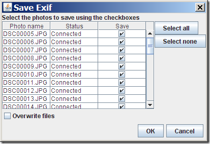
Prune lets you adjust for the time difference between the camera time and the GPS time (the former is usually the local time, the latter UTC). You can also set the correlation limits, i.e. how close the time or distance a trackpoint needs to be in order to be correlated with a picture. After correlating photos with track, you still have to select Photo => Save to EXIF to have the position data written into the picture’s data:
Save to EXIF

If you leave “Overwrite file” unchecked, the original will be saved with “_original” appended to the file extension; it would probably make more sense to append it to the filename instead, but that’s apparently a limitation of EXIFTool.

Another useful new feature in Prune is the ability to create a GPX file from an imported set of geotagged photos. Add the photos to the file list with the Photo => Add Photo command, select File => Export GPX, and Prune will create a GPX track file, connecting all the points where a photo was taken in the correct order.

Other new features in Prune:

  • Automatic correlation of photos with points based on timestamps
  • Manual disconnection of photos from points
  • Reading of photo thumbnails from EXIF data (speeds up photo loading)
  • KML and KMZ export now includes altitude option for airborne tracks
  • Track points in map can be connected by lines
  • On loading a text file, fields are now guessed according to data or column headings
  • Polish language

Prune is released under GPL, and there’s a copy of the source code available for download. Not sure I would use Prune instead of GeoSetter for photo geotagging in Windows, but it looks like a great free alternative for Mac and Linux users, who have fewer free geotagging options.



RouteConverter Updated – Java GPS Route Editing And Conversion For Windows (Mac And Linux Too?)

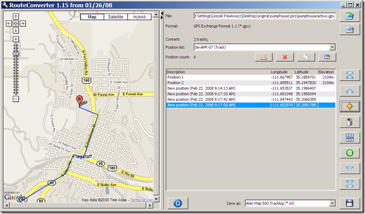
Route Converter, covered in a previous post, is a program for editing GPS routes, and converting them from one format to another. The biggest complaint I had about the previous version is that it didn’t have a visual interface for viewing and editing routes. The program’s author writes to say that he’s now added a Google Maps interface that not only displays the route points, but lets you edit them within that interface:

2-22-2008-9.20.19 AM

Add, delete, and move points within the list using the buttons at right; they’re not directly labeled, but a popup label will show up when you hover over them with the mouse. Click on a position in the list, and that position will be shown in the Google Maps window with the red pin; click and drag to move that pin to wherever you want, and the position in the list updates automatically. To enter a position directly, or to change the point description, double-click on the appropriate field in the list to select it, and enter the new data.

Other new features include a few additional route formats and bug fixes. While it still doesn’t support as many formats as ITNConv, I now prefer RouteConverter’s interface. The version of RouteConverter described here is for Windows; the download page also includes versions for both Linux and Mac, but they’re labeled “experimental”, and “reduced functionality”, and I haven’t tried them myself.