blankblank blank


Archive for the 'Garmin' Category Page 2 of 13


Handheld GPS Units – Beyond The Manual

It’s no secret that the manuals many GPS makers puts out with their handheld GPS units aren’t always ideal. They can be very confusing, give cursory explanations of more complicated functions, and often leave out any mention at all of advanced functions. Plus, as firmware gets updated and features get added/dropped, the printed versions become out-of-date, and even the online PDF versions lag in adding descriptions of new features. Here are some online resources to help plug the info gaps for these units.

GPSFaqs.Org: Contains comprehensive FAQs for the following Garmin models –

If your eTrex model or GPSMap isn’t listed above,  you may find the answer you’re looking for in the FAQ for a different but comparable model, since most of these models share a similar OS/interface.

GPSFaqs.Org also has FAQs for Magellan GPS units; coverage is strong for Explorist models, but cursory for Triton models.

Yahoo Groups: A number of active groups for the GPSMap series (60Cx/60CSx and 76Cx/76Cx), as well as eTrex models (general and the Legend). Not a lot of action in the Triton or DeLorme forums.

Groundspeak GPS And Technology Forum: Free registration required. Regular postings/discussion on GPS units from a variety of manufacturers, mainly Garmin and DeLorme.

DeLorme Community Forum: Probably the best source for info about the DeLorme PN series of GPS receivers.

TritonForum: By far the best source of info for the Magellan Triton series.

GPSFix Wikis: Created by Scott at GPSFix.Net, an exceptionally strong resource for info about modern Garmin units in the following series:

gpsinformation.net: Tons of general info about GPS, and pages about specific units from a wide variety of makers, some dating back to the 1990s! May take a bit of hunting to find the info you’re looking for.

<!–wsa:Moagu-banner–>


Status Of The Garmin Map Compiler cgpsmapper – ?

Both GPSTracklog and GPSFix link to a page on the cgpsmapper website that indicates development will be ceasing on that Garmin map compiler. This is a real shame; over the past decade, this compiler has driven the creation of thousands of freely-available maps for Garmin GPS units, as well as being a boon for creating your own personal custom maps. I use it all the time – just posted about it again recently. Even some international Garmin units have sold maps created with cgpsmapper.

In a more detailed post at the Yahoo Map Authors group, Stan Kozicki, the author of cgpsmapper, talks about this issue in greater detail. His biggest problem appears to be his inability to keep up with changes in the Garmin binary map format, since Garmin doesn’t formally document it; I know they recently made a change that broke map “locking” in his commercial version of the program. He’s apparently still talking to Garmin about some kind of continuation of the program for use in non-commercial independent map creation, with them possibly supplying more detailed information about the Garmin format. But Garmin appears to want the commercial versions of cgpsmapper to go away in favor of their commercial (and expensive) Map Product Creator.

I really hope that Stan and Garmin can come to some kind of agreement; I think the availability of cgpsmapper and the Garmin maps it creates helps drive commercial demand for Garmin units. Ten years ago, Garmin and Magellan had comparable market shares in the handheld GPS field; today, Garmin overwhelmingly dominates that arena, and is also far more popular than Magellan in the automotive arena as well. I don’t know how much the ability to create custom Garmin maps with free software had to do with that (creating custom Magellan maps is far more difficult, and requires proprietary software), but it certainly didn’t hurt.

In any case, there’s no indication from Stan that he will withdraw the last free version of cgpsmapper from availability anytime soon, and maps created with that version should work fine on most current Garmin models. Other free options for compiling Garmin map files include mkgmap, MapTk and MapDekode. I’ve been playing quite a bit with mkgmap recently, and am pretty impressed; it’s command-line only (like cgpsmapper), but I’m working on a GUI that  will support most of its features/options.


Garmin Basecamp Revisited

It’s been a bit more than a year since I first looked at Garmin’s free Basecamp software, and wasn’t terribly impressed. I did say, “Hopefully future versions will be snappier, and add more features.”  I just did a GPS presentation to a local hiking group, and in preparation for that took a full look at the latest version of Basecamp (3.05). In short, it’s a major improvement over the first release; it’s now better than Garmin’s classic MapSource program for uploading/downloading/managing data. It’s so improved that it wouldn’t be a bad basic choice for creating data for use with non-Garmin GPS models; just export the data to GPX format, then use a program like EasyGPS to send it to your model. As an added bonus, it’s available in both PC and Mac versions.

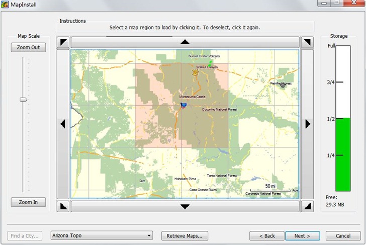
Probably the most important addition is an associated tool called MapInstall, that lets you upload Garmin-compatible maps to your GPS unit. Prior to this, the only complete tool for doing this was Garmin’s MapSource program, only available if you purchased a Garmin mapset, or Garmin’s Trip and Waypoint Planner software, sold for $30. If you wanted to use free mapsets like those available at the GPS File Depot, you were out of luck; now, you’re not. MapInstall isn’t as good for uploading and managing maps as MapSource, but it should be good enough for most people:

mapinstall

But there are lots of other useful new features:

  • Faster and less buggy than earlier versions
  • Tiled (poster) printing of installed mapsets
  • Support for Garmin Custom Maps and Birdseye Imagery
  • Better route management
  • Conversion of tracks to simplified routes
  • Better waypoint, track and route management
  • Better export to Google Earth
  • Ability to import mapsets pre-installed on some GPS models

Still some issues left, some kind of weird:

  • Import of KML files is iffy
  • Help file is still incomplete
  • Only supports USB-interface models; older serial models are out of luck (though you can still export data and use EasyGPS to upload it
  • There are features listed on the update/download page that don’t seem to exists, e.g. “Added printing of USGS Quads and other public land survey areas.”
  • Be nice to be able to simplify tracks and still keep them as tracks; now, you can only save a simplified route.
  • Basecamp insists on exporting waypoints to GPX, Google Earth format with a timestamp even if you’ve created them in the program (and don’t want a timestamp).

I did some Basecamp demo videos as a reference to what I presented at my talk, and have put them up on YouTube; not terribly exciting, but maybe you’ll find them useful.


Archive Of Old GPS Firmware And Software Updates

If you ever feel the need to roll your GPS back to an older version of the system firmware, you likely won’t find it on the manufacturer’s website; they typically only have the latest version. The Garmin Software Archives has a pretty extensive collection of  older firmware updates that covers most Garmin units released over the past dozen years, as well as some for other makers as well (Bushnell, deLorme and Magellan). The collection is most comprehensive for handheld units (need an update for your 12XL?), but includes some marine, aviation and automotive units as well. The archive also had older software updates for Garmin programs like MapSource, Basecamp, WebUpdater, POILoader , nRoute, even the old USB programmer for Garmin’s proprietary memory card format. Some programs (e.g. MapSource) don’t let you downgrade to an older version, so you’ll need to uninstall your current version, then install a valid older version from one of your map discs before using one of the updaters from the archive.

Almost forgot: there’s a link at the archive to a great Garmin PDF from 2005 on using your GPS with paper maps; also includes a page of map tools that you can print on a transparent sheet and use with USGS 1:24K topo maps (map grid for UTM and compass rose, and two scale rulers).


Not So Free Tools For Custom Garmin Vector Maps XVII: Paid Apps

After 16 posts on free tools for Garmin vector map creation, thought I’d throw in some links to non-free apps. Free apps are great, but they often have a steep learning curve, and require more effort to use; paid apps often have more features, and come with support.

GPSMapEdit: Free evaluation version already covered here; paid version offers more features.

MapMan: Free version already covered here; paid version adds a few more features. Not clear to me it’s worth the price (30 UK pounds); GPSMapEdit and MapWel are better choices in that price range.

Global Mapper:  Can export vector data in Polish Map (.mp) format, along with proper level formatting data. Supports just about every vector GIS format out there for input, and can re-project just about any coordinate system to the geographic/WGS84 coordinate system required for Garmin maps. At $300, hard to justify for that use only, but it’s a full featured vector/raster viewer and format converter as well.

MapWel: A full-featured vector map editor and compiler, with routing support recently added. Lots of supported import vector formats (shapefile, Polish Map Format .mp, OpenStreetMap OSM, GPX, GDB, KML, KMZ, DBX, PLT, WPT); you can also import raster imagery as a guide for drawing vector features.. Vectorizes raster images into Garmin format; allows custom symbology; very fast compiler. Biggest drawback has been incompatiblity with MapSource/Basecamp, but there is a somewhat clumsy workaround for that now. Basic version has a limited feature set, and only lets you create maps for a single unit; Advanced version removes those limitations.

gpx2img: Converts GPX tracks and waypoints to transparent .img vector map files, with customizable symbology. Not officially released yet. Based on the features listed on the website, you can get all of this functionality using free tools, but it may offer an easier workflow.

That’s pretty much all I’ve got for free and paid apps; if I’ve missed one, let me know. I’m working on an updated GUI for the mkgmap compiler, and that should be out sometime next week.


Free Tools For Custom Garmin Vector Maps XVI: Map Uploaders And Managers

If you’ve created a custom Garmin vector map using any of the tools in posts I through XV of this series, you’ll need a way to upload them to your Garmin unit. The simplest way is to copy them directly to the Garmin folder in your unit’s memory using a USB mass storage connection, or plugging a memory card into an external reader.. For older units, you’ll need to rename the binary .img file to gmapsupp.img, and it will replace any maps you already have there. With newer Garmin models (the Colorado/Oregon/Dakota/GPSMap 78 series), you don’t have to rename them, or replace mapsets currently in memory; they will automatically show up in the list of available maps.

There’s also a number of free tools that aid in either uploading maps to the Garmin, or installing them as standard mapsets for use with Garmin’s MapSource and Basecamp software.

Map uploaders:

SendMap: From the author of the cgpsmapper compiler, and the most fully-featured map upload program. There used to be a limited free version and a paid “Pro” version, but the “Pro” version is now completely free. Features include (from the website):

  • Automatic recognition of devices which are visible as USB-storage drives
  • Store a file list on disk (TXT file) that can be used later with ‘-f’ option
  • Support up to 2GB
  • Check for available memory in GPS – now sendmap will not start the upload process if there is not enough memory
  • Ability to change the ‘region name’ for every file
  • Support for uploading several TYP files (customization of built in types) – TYP files are used on maps with the same region name
  • Uploading of several unlock keys
  • Free license for distributing the program together with maps
  • Creation of EXE files merged together with maps, with user defined EULA
  • Creation of EXE files with predefined expiration data

The program can be used in either command-line or GUI; I find the latter adequate for most options. PatchIMG, GPS Send Map and img2gps (previous post) are alternate GUIs to SendMap, but they were designed for use with earlier releases of the limited free version of SendMap, and I don’t think they support all the options in the Pro version.

One drawback of SendMap is that it doesn’t directly support uploading to memory cards in readers, only to GPS units. For older Garmin models with USB 1.1 interfaces, this can result in slow transfer speeds for large mapset files. But you can generate a “gmapsupp.img” file on your computer, then manually copy it into the “Garmin” folder on a memory card using a much faster USB 2.0 card reader.

MapUpload – Free .img uploader; posted about earlier. Also doesn’t support memory card uploads, but doesn’t give you the option of creating a separate gmapsupp.img file. It does give you the option of adding a .img file to the existing maps loaded on the GPS, instead of just replacing them completely.

Mapset Managers/Installers:

These install sets of .img files into MapSource and Basecamp, so that you can select and combine them with other mapsets; also may offer other features, like the ability to uninstall a mapset. They are graphic front-ends to the cgpsmapper/cpreview compiler program; you’ll need to have at least the free version installed in order to use them.

MapSet Toolkit: The best tool out there; covered in an earlier post, but now with even more features, like an interface to the GMapTool program. Still under active development.

GPSMapManager: An alternate mapset installer; no longer under active development, and MapSet Toolkit is much better.

The GPS File Depot has a tutorial on how to create PC and Mac installers for mapsets, in case you want to distribute your map files in a more user-friendly format.

Free Tools For Custom Garmin Vector Maps XV: MapDekode

MapDekode: MapDekode is an alternate compiler for generating Garmin vector maps. It uses its own DBX coding language, which can be generated from OziExplorer *.plt/*.wpt files using the program, or converted from other formats using the program GPS TrackMaker. Creating the data files seems to be kind of a pain, and the map code format and compilation process are so different from the more-common Polish map/cgpsmapper process that I haven’t tried it out. If you have, and can point out any advantages, please leave them in the comments.

Sources for more info on MapDekode (plus some tools):

MapDekode Yahoo forum: Not a lot of activity here, but the Files section contains some useful utilities.

  • ImgTransparent: Makes a .img map file transparent (other programs like GPSMapEdit and MapTk can do this as well)
  • mpConv: Converts maps in the more common Polish Map format (.mp) to DBX.  MapTk contains an alternate converter
  • shpdbxconv: Converts shapefiles to DBX format

Map Authors Yahoo forum: Not a lot of interest in MapDekode in the forum itself, but the Files section has some useful stuff.

  • TM_MapDekode.zip- A PDF file describing how to create DBX files using GPS Trackmaker (not an intuitive process)
  • MapDekode plot analyzer – Analyzes OziExplorer *.plt files for use with MapDekode


Free Tools For Custom Garmin Vector Maps XIV: OSM Tools B

Continued from the last post, a few more tools for creating Garmin vector maps using OpenStreetMap data; these are more comprehensive map creation programs.

GroundTruth: A tool for generating full maps from OSM data and other sources. Feature set (from the wiki):

  • Support for custom line and area styles
  • Support for POI custom icons for POI
  • Map rules can be shared among mappers by publishing them on this Wiki.
  • Automatic generation of TYP files
  • Generating relief contours using NASA’s SRTM data
    • Generating OSM files with contours (a successor to Srtm2Osm)
  • Automatic downloading of OSM vector data
  • Support for additional map features (like map transparency) available through cgpsmapper
  • Conversion of national characters into the ones supported by Garmin units
  • Generation of Mapsource preview files
  • Registration of generated maps into Mapsource
  • Automatic uploading of generated maps onto a GPS unit
  • Command-line interface

The last has kept me from trying it out; the requirement to set map data and parameters using command-line options, outlined in the wiki GroundTruth manual, is a bit more effort than I’m willing to put in. Igor Brejc, the author of GroundTruth, also thinks that there’s an issue with publicly distributing maps created using Ground Truth. From the wiki:

GroundTruth uses 3rd party cgpsmapper software to generate the actual .IMG files for Garmin units. Unfortunately the license for the free version of cgpsmapper states that the produced maps cannot be distributed for commercial purposes. This is in conflict with the OSM license. The bottom line is: you cannot distribute Garmin maps made with the free / shareware or personal version of cgpsmapper if they contain OSM data. You can, however, distribute contour maps, since the original SRTM3 data is in public domain.

I’m not sure this is the case; while you may not be able to sell the maps created, the cgpsmapper license allows you to distribute them without restriction if you don’t charge for the maps. So if you weren’t going to sell them in first place, there may not be a conflict. But I’m no lawyer. I would think that GroundTruth might be able to get around this restriction by using an alternate, fully-free map compiler like MapTk or mkgmap.

Here’s a screen capture of a GroundTruth map from Igor’s website:

groundtruthcapture

OSM Map Composer: OSM Map Composer is an alternate program for generating full Garmin vector maps from OSM data (and other sources). The full feature list is long, and can be seen in English for an older version (0.60) at this website. It seems to have much of the functionality of GroundTruth, but also has a graphical interface as well:

osmcomposer

And since it uses the mkgmap compiler, there should be no possibility of license conflicts that would restrict distribution. The biggest problem for some might be the German interface. In my case, my German is pretty weak, and a need to create an OSM-based map hasn’t come up for me yet, at least not strong enough to make me work my way through translating the interface. There used to be an English-based interface, but the author indicates that he dropped that effort based on lack of interest. There is still an English manual for the older version available at this link, which might help you get started. And the sample maps shown at the wiki look pretty nice:

OSMComposersamples