Route Converter, covered in a previous post, is a program for editing GPS routes, and converting them from one format to another. The biggest complaint I had about the previous version is that it didn’t have a visual interface for viewing and editing routes. The program’s author writes to say that he’s now added a Google Maps interface that not only displays the route points, but lets you edit them within that interface:
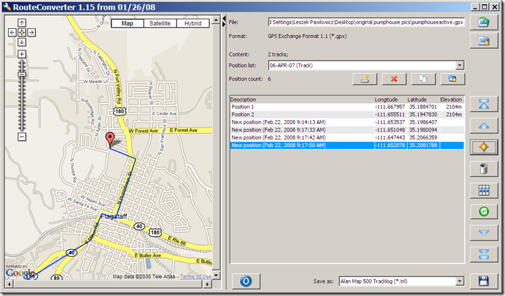
Add, delete, and move points within the list using the buttons at right; they’re not directly labeled, but a popup label will show up when you hover over them with the mouse. Click on a position in the list, and that position will be shown in the Google Maps window with the red pin; click and drag to move that pin to wherever you want, and the position in the list updates automatically. To enter a position directly, or to change the point description, double-click on the appropriate field in the list to select it, and enter the new data.
Other new features include a few additional route formats and bug fixes. While it still doesn’t support as many formats as ITNConv, I now prefer RouteConverter’s interface. The version of RouteConverter described here is for Windows; the download page also includes versions for both Linux and Mac, but they’re labeled “experimental”, and “reduced functionality”, and I haven’t tried them myself.
In a previous post, I used MicroDEM’s ability to create GIF Google Earth overlays with transparency to create selective overlays of MicroDEM terrain analysis products. But you can use this ability with any georeferenced raster image, including topo maps, as long as the areas of the graphic you want to have transparent are white. One example would be USGS 24K topo maps, but these often have large areas that aren’t white, as in this case:
Continue reading ‘Creating "Transparent" Topo Map Overlays For Google Earth’
In a previous post, I talked about using MicroDEM to easily create Google Earth ground overlays, images draped over Google Earth terrain in the correct position, like this terrain-shaded topo map (viewed in Google Earth):
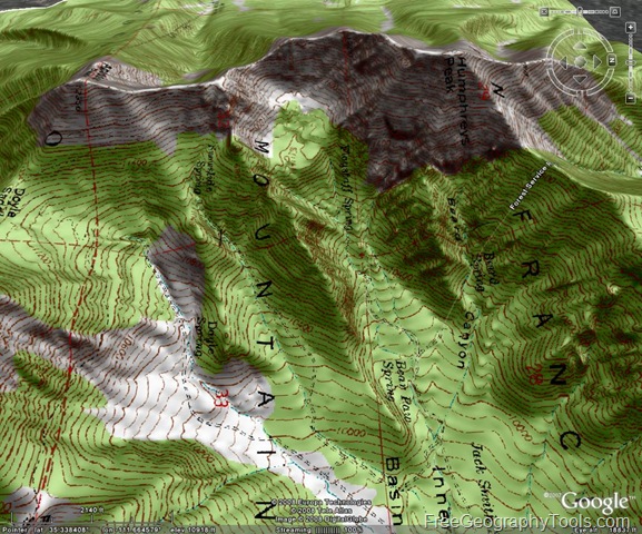
But you can also create a Google Earth ground overlay in MicroDEM as a GIF with transparency, where any part of the image that’s white will be invisible in the Google Earth overlay. There are a number of MicroDEM analysis functions that can produce a graphic product with the data product in color and the background in white. One example would be the terrain category function, where you can select parts of terrain based on parameters like slope, elevation, aspect ratio, and relief. Suppose I have a DEM displayed in reflectance mode:
Continue reading ‘Google Earth Ground Overlays With GIF Transparency’
In Google Earth, a ground overlay is an image that’s been imported into the program and “draped” over terrain as a substitute for the default imagery. In the Free and Plus versions of Google Earth, you have to position the overlay manually to put it in the right geographical context, stretching and rotating it until it’s properly positioned. Google Earth Pro is able to open some kinds of georeferenced images (like GeoTiffs), and automatically drape them in the correct geographic position, but at $400 it’s not for everyone. The free GIS program MicroDEM has recently added the ability to automatically create a Google Earth overlay from any georeferenced image it can open, including GeoTiffs, and formats like JPEG and BMP if they have worldfiles associated with them
Continue reading ‘Creating Google Earth Ground Overlays From Georeferenced Images’
The US Government’s National Oceanic And Atmospheric Administration (NOAA) has placed online 21,000 maps, downloadable in both JPG and MRSID high-resolution formats (see this post for several free MRSID viewers and converters). The maps are mainly historical nautical maps dating from 1655 to 2001, but there are also a fair number of Civil War battlefield maps, many of them contemporary with the war, and not all of them nautical in nature.
Continue reading ‘Historical Nautical And Civil War Maps’
In the comments to a previous post, someone asked if there were any place where you could find a legend for Garmin GPS unit waypoint icons. I pointed him to this Garmin page, which has a partial legend for Garmin MapSource icons, but it turns out that MapSource icons don’t always resemble the corresponding icons on a Garmin GPS unit.There’s no legend for Garmin GPS unit waypoint icons anywhere else that I could find, either on the Web or in Garmin’s own documentation. For future reference, I’ve put together the following tables of Garmin waypoint icons by category. This is how they’re displayed on my Garmin 60Cx, but they may well be different on other Garmin models. In parentheses below the label is the MapSource Symbol category which contains this icon. If your unit has different or additional icons, and you can send a copy of them to me, I’ll add them to this post.
Continue reading ‘Garmin GPS Unit Waypoint Icons Table’
As a supplement to my recent posts on creating custom waypoint icons for Garmin GPS units (1, 2, 3), I’ve put together a list of Garmin units that I believe, based on first-hand reports, and my interpretation of their manuals, support custom waypoint icons. It’s hard to say for sure, since Garmin doesn’t specifically mention custom waypoints in any any of their manuals; in fact, they seem to want to make it as difficult as possible to find out how to use this capability. So I can’t assure you with 100% certainty custom waypoint icon support for any models other than the GPSmap, Rino, and Astro models.
Currently-available models
|
|
|
|
| GPSmap 60Cx |
GPSmap 60CSx |
GPSmap 76Cx |
GPSmap 76CSx |
|
|
|
|
| eTrex Venture Cx |
eTrex Vista Cx |
eTrex Legend Cx |
eTrex Vista HCx |
|
|
|
|
| eTrex Legend HCx |
Astro GPS |
Rino 520 HCx |
Rino 530HCx |
|
|
|
|
| eTrex Summit HC |
eTrex Venture HC |
Quest |
Quest II |
Note: The new Garmin Colorado series (300, 400t, 400c, 400i) does *not* currently support custom waypoints; I know some people have flagged this to Garmin as an issue, and perhaps they’ll add it in future firmware updates. Given their lackadaisical support for this function, I wouldn’t hold my breath.
6/11/2010: Newer models in the Oregon series (the Oregon 450, Oregon 450T, Oregon 550 and Oregon 550T) do support custom waypoints, but in a different way than older Garmin models; see the Oregon wiki for more info. The new GPSMap 62 and 78 series support them as well.
Older models (no longer sold)
GPSmap 60C
GPSmap 60CS
GPSmap 76C
GPSmap 76CS
eTrex Legend C
eTrex Vista C
Rino 520/530
Note: Version 6.15.3 of MapSource accidentally dropped support for custom waypoint icons; version 6.15.4 puts it back. Make sure you have the most recent version.
The two previous posts in this series dealt with creating and uploading custom waypoint icons to supported Garmin GPS units. But while third-party software for handling GPX data (both upload and download) will download the waypoints, most (if not all) don’t support display of these custom waypoint icons. For that, you’ll have to use Garmin’s MapSource program (aka Trip and Waypoint Manager), and set up custom waypoint icon graphics so that MapSource can import and use them.
Continue reading ‘Creating Custom Waypoint Icons For Garmin GPS Units III – Custom Waypoint Icons In MapSource’

