blankblank blank


Author Archive for Leszek Pawlowicz Page 32 of 79


The Big List Of Free Basic GIS Programs – A Through H

The backlog of topics for this blog continues to grow beyond my ability to keep up with it, and current work demands make it unlikely I’ll be able to catch up soon (though I should still be able to put up new posts at about the same rate). So I thought I’d do a quick set of posts on various types of GIS software, including both those that I have looked at in some detail, as well as those that I’ve given either a cursory look, or none at all. Let me know which ones I’ve missed, and I’ll add them to the list (and put up a separate post on them if warranted). I welcome comments on any of these programs, especially those I haven’t really posted on yet; if the comment is long enough, I’ll put it up as a full guest post. And I’m likely to come back to some of these in greater detail in the future.

Continue reading ‘The Big List Of Free Basic GIS Programs – A Through H’


List Of Map Products From the USGS

Stopped by the USGS Seamless Server recently for the first time in a while, and noticed they’ve added a drop-down list titled “Available Interactive Maps”. Listed there are a fairly wide-ranging set of data resources they’re working on; some are mostly duplicates of the Seamless Server data but with a slightly-different focus, while others contain unique data.

ARMI: A data viewer and retriever for the USGS’s Amphibian Research and Monitoring Initiative, a program designed to study and hopefully slow down the recent drastic reductions in amphibian numbers. Data includes factors like pesticides, hydrography, climate/weather and more.

USGS Projects In Afghanistan: Includes both an interactive data viewer and a list of downloadable data, including:

  • Landsat data, including 6-band corrected imagery by 1:250K quads
  • Aster Level 1A and 1B data
  • SRTM 90-meter DEMs, with void filling
  • German, Russian and USGS geology maps
  • Full sets of Russian topographic maps, 1:50K and 1:200K

U.S.-Mexico Border Environmental Health Initiative: Interactive data viewer for “satellite imagery, orthoimagery and integrated geology, hydrology, transportation, geographical names, potential sources of contaminants, demographic data for population density, Nexrad daily weather, and boundary datasets”.

CEOS WG on Information Systems and Services: A viewer showing coverage areas for various forms of earth observation (satellite and aerial observations). Coverage areas only, no data.

Drought Monitoring: Drought and vegetation index data for the United States.

Elevation Derivatives For National Applications (EDNA): Hydrological-oriented database (30-meter US resolution) with raster and vector data:

  • Aspect
  • Contours
  • Filled DEM
  • Flow Accumulation
  • Flow Direction
  • Reach Catchment Seedpoints
  • Reach Catchments
  • Shaded Relief
  • Sinks
  • Slope
  • Synthetic Streamlines

Integrated Vegetation Mapping Viewer: NDVI (normalized differential vegetation index), Fire Potential, Percent of Average Seasonal Greenness, and more.

MRLC: Focused on the National Land Cover Database (2001 and 1992).

MOPEX: Focused on stream, watershed and hydrological data for the US.

Topobathy: A few small sections of bathymetric shaded relief (e.g. off the coast of San Francisco, the Seattle bay area), but otherwise not much different than the USGS Seamless Server.


Using Google Earth Ground Overlays To Display Shapefile Data

The best way to display shapefile data in Google Earth is to convert it directly into vector KML format, and I’ve covered several ways to do that for free or cheaply, including stand-alone programs and online converters. Of all these options, I prefer using either shp2kml or Shape2Earth because of the flexibility they offer in setting display attributes like color and shape. But there’s another option: convert shapefile data into a raster image, and then display it in Google Earth as a ground overlay. This has a few advantages over vector KML format:

Continue reading ‘Using Google Earth Ground Overlays To Display Shapefile Data’


Beating The Garmin 2025-Map Limit With US Topo Maps

Many recent Garmin GPS mapping units (like the 60Cx and 76Cx units) have a maximum limit of 2025 map sections that you can upload directly to the unit, and you’ll get an error message if you try to exceed the limit. If you try uploading more than 2025 to a microSD card in a card reader, you won’t get an error message, but the GPSr unit will still not be able to display the data from more than 2025 maps after you put the microSD card back into it. This wasn’t such a big deal when memory was expensive, and 128 MB of memory was considered a lot – there was no way you come close to that 2025 limit with that little memory. But these days you can get a 2 GB microSD card for a Garmin unit for less than $20, and you could easily fill such a card with more than 2025 maps if that were possible.

Continue reading ‘Beating The Garmin 2025-Map Limit With US Topo Maps’


A Look At OpenStreetMap's TIGER Data Exported To A Garmin GPS

Rich at GPS Tracklog cites OpenStreetMap’s recently-completed importation of the TIGER road data for the US, and challenges me to take a look at exporting it to a Garmin GPS (based on this post, I assume). OK, sure.

Continue reading ‘A Look At OpenStreetMap's TIGER Data Exported To A Garmin GPS’


Urban & Environmental Modeler's Datakit

Via the Kelly Lab Blog, the Berkeley/Penn Urban & Environmental Modeler’s Datakit has an enormous set of vector and raster data for the contiguous 48 US states:

Vector:

• Municipal, county, metropolitan area, and state boundaries, as assembled from the US Census Bureau’s 1990 and 2000 TIGER data.
• 1990 and 2000 census block and census tract boundaries and selected attributes, including net housing and population densities.
• Highway, railroad, and urban rail transit networks; and air and seaport locations as assembled from the U.S. Department of Transportation’s Bureau of Transportation Statistics.
• Locations of major employment centers and employment data for 1994 and 2003.
• Boundaries of all federal lands, including national parks and monuments, national forests, Bureau of Land Management lands, and military facilities.
• Locations of all major water bodies including rivers, streams, lakes, and reservoirs.

Raster:

• Municipal, county, metropolitan area, and state boundaries.
• Census block and census tract boundaries and selected attributes, including net housing and population densities (blocks) and population, housing, and demographic data (tracts).
• Boundaries of all federal lands, including national parks and monuments, national forests, Bureau of Land Management lands, and military facilities.
• Elevation and slope data generated from the National Elevation Dataset (NED).
• Comprehensive land cover data for 1992 and 2001 from the U.S. Geological Survey, including agriculture, forest, pasture, urban, and wetland locations.
• Locations of all major water body polygons, including lakes and reservoirs.
• Locations of lacustrine, palustrine, and riverine wetlands from the National Wetlands Inventory.

Data is in Lambert Conformal Conic NAD83 projection.


Options For MGRS Coordinate Conversion And Viewing

My visitation logs show a surprisingly large number of visitors interested in converters for the Military Grid Reference System (MGRS), the standard geocoordinate system used by members of the NATO Alliance. So I thought I’d do a quick roundup of previous links/posts related to MGRS, and then talk about another program that might be useful if you’re working in that coordinate system.

Continue reading ‘Options For MGRS Coordinate Conversion And Viewing’


Prune Updated: Now With Automated Photo Geotagging For Windows, Mac, And Linux

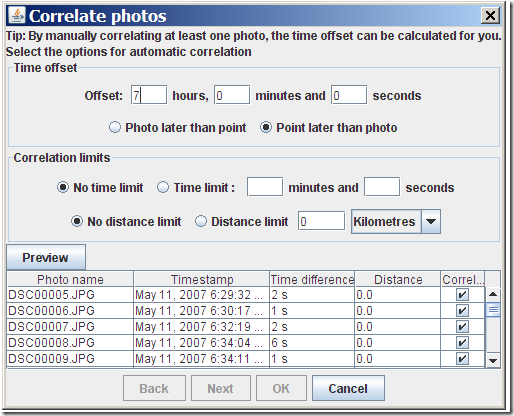
Prune is a Java-based GPS-track viewing and editing program that runs in Windows, Mac and Linux. When I last posted about it, the photo geotagging capability was a bit awkward – it required you to manually link a photo to a trackpoint, not automatically correlating trackpoints with photos based on time like most photo geotagging software. Version 4.1 is now out, and it now can automatically correlate and tag photos with data from a GPX track file. You need to have EXIFTool installed on your system; for Windows, put it the same folder as Prune, or into a system folder. Open a GPX track with File => Open Command, select either individual photos or an entire folder with File => Add Photos (or Photo => Add Photos). Select the photos you want to geotag in the file list at left, then select Photo => Correlate All Photos:

geotag photos with Java Prune

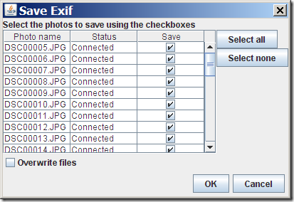
Prune lets you adjust for the time difference between the camera time and the GPS time (the former is usually the local time, the latter UTC). You can also set the correlation limits, i.e. how close the time or distance a trackpoint needs to be in order to be correlated with a picture. After correlating photos with track, you still have to select Photo => Save to EXIF to have the position data written into the picture’s data:

Save to EXIF

If you leave “Overwrite file” unchecked, the original will be saved with “_original” appended to the file extension; it would probably make more sense to append it to the filename instead, but that’s apparently a limitation of EXIFTool.

Another useful new feature in Prune is the ability to create a GPX file from an imported set of geotagged photos. Add the photos to the file list with the Photo => Add Photo command, select File => Export GPX, and Prune will create a GPX track file, connecting all the points where a photo was taken in the correct order.

Other new features in Prune:

  • Automatic correlation of photos with points based on timestamps
  • Manual disconnection of photos from points
  • Reading of photo thumbnails from EXIF data (speeds up photo loading)
  • KML and KMZ export now includes altitude option for airborne tracks
  • Track points in map can be connected by lines
  • On loading a text file, fields are now guessed according to data or column headings
  • Polish language

Prune is released under GPL, and there’s a copy of the source code available for download. Not sure I would use Prune instead of GeoSetter for photo geotagging in Windows, but it looks like a great free alternative for Mac and Linux users, who have fewer free geotagging options.