I’ve posted before about Digipoint (version 1 and version 2), a web app that lets you select points in a Google Maps interface, then export their coordinates in a variety of formats. Version 3 of Digipoint is now out, with some modest improvements:
- A new interface, a bit easier to use, and which works better in browsers where the default font size has been modified
- Fly-to: Specify an address, country, or location, and the map will automatically go there. There are also a limited number of pre-specified country/region links, where clicking on the link takes you to the area automatically
- In previous versions, you had to copy/paste text for a particular export format like CSV or KML; you can now download the file automatically
- For exported shapefiles, a corresponding prj file is also created to specify the coordinate system (your choice of geographic or UTM; WGS84)
- Help section added
Still supports the same export formats as before: CSV, TXT, TAB, BLN (Surfer), GPX, KML, DXF and shapefile. Versions one and two are still available if you want them, but there’s no good reason to use them anymore.
Just got an email from Zonums Software that, after a prolonged hiatus, they’ve resumed development of free stand-alone and web-based geographic tools. I’ve posted previously on their stand-alone KML to shapefile converter, but a glance through that post’s comments will reveal that it has some serious bugs in it. While those are still being fixed, Zonums has released an online KML to shapefile converter:
Continue reading ‘Online KML To Shapefile Converter’
A while back, I posted on GeoFabrik’s repository of Open Street Map (OSM) data in shapefile format, covering mainly Europe and parts of Asia. CloudMade now has this data freely available for download as well, but not just in shapefile format, and not just Europe, but every continent (including Antarctica). Broken down by country/state, you can download:
- OSM XML extracts
- Garmin Map Files (OSM.err edition)
- Osmosis country bounding polygon
- Shapefile extracts
- Navit maps
- GPX POI
- TomTom POI
The latter two are a bit lacking in data now, to put it mildly, but presumably will grow in size with time. CloudMade is developing APIs to deliver the OSM map data in web and mobile format, but these are currently in alpha and limited to developers.
The Garmin data comes as a gmapsupp.img file, which you can copy directly to the SD/microSD card of a compatible Garmin unit; see this post for more info. The problem with Garmin map data in this format is that you are limited to having only the data embedded within that single file loaded into your GPS; you can’t combine it directly with other Garmin mapsets. And because the gmapsupp.img file can contain multiple sub-tiles, you can’t add it to the MapSource program using MapSet Toolkit; trying to do so will only make a single sub-tile visible. But there’s a way to split that gmapsupp.img file into its constituent sub-tiles, making it installable into MapSource, and I’ll cover that in tomorrow’s post.
ogr2ogr is a simple command line utility that converts between supported vector file formats. For those who don’t like dealing with command line programs, and need only limited conversion capability, Inventis has written a simple Windows front-end for ogr2ogr called ogr2gui:
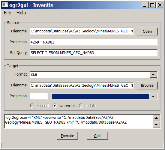
Documentation is limited, so it’s not clear which input formats are fully supported. For example, input shapefiles work, but I had problems getting E00 files to convert (see this post for an E00 to shapefile conversion process that does work). Hopefully documentation will improve with time along with functionality (this is already the fourth release).
Output formats are limited to:
- Shapefile
- MapInfo
- KML
- GML
- CSV
Converting shapefiles to Google Earth’s KML format works as long as the shapefile is in latitude/longitude format, WGS84; attribute table data added to the placemark pop-up for point shapefiles, but not lines or areas. There are better converters for shapefiles to KML conversion like shp2kml, but this is a good choice for converting other less-well-supported vector formats into the supported output formats..
Over a year ago, I posted on Google Map Creator, a program from the Centre for Advanced Spatial Analysis that lets you convert shapefiles into thematic colored maps for display in Google Maps. They’ve just created a new site called MapTube , “a place to put maps”, that collects links to maps created with Google Map Creator. You can search for maps covering a particular topic or area, and select multiple thematic maps for simultaneous display, to see if any relationships are visible between different datasets. Sliders set the transparency of the various maps displayed, and you can turn the legends on and off by clicking on the legend icon in the map thumbnail:
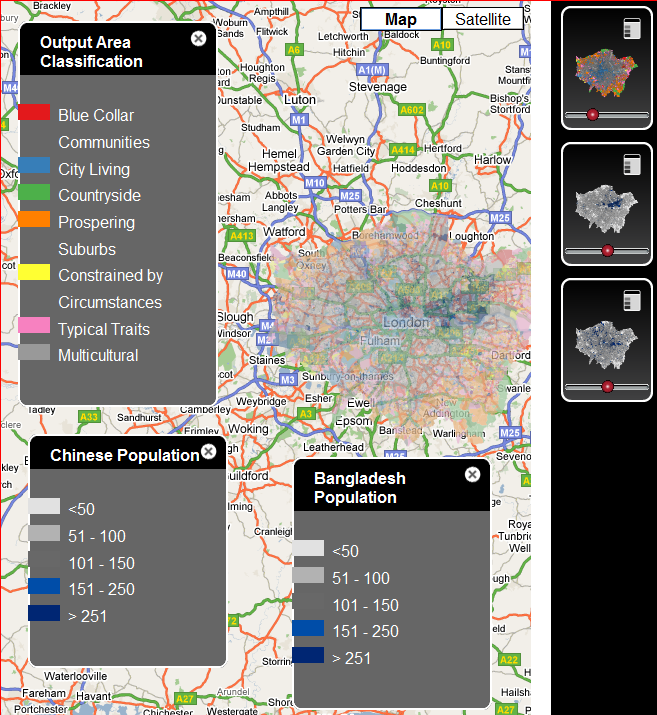
You can also create an account that lets you add your own maps to MapTube, but you have to host the actual map data yourself on your own server; MapTube’s function will be to index the metadata, preview the maps, and allow people to view them in a Google Maps interface. The current maps are heavily Anglo-centric (not surprising), and limited in number; the site’s ultimate usefulness will depend on how many people actually wind up creating maps for it. It would help if they could add an interface to MapTube directly to the Google Map Creator program, and also if there were some way in the program to directly upload Google Map Creator maps to a centralized data server and pass that link directly to MapTube.
A while back, I posted on the Shape Checker utility, a program that can supposedly fix damaged shapefiles. I say “supposedly” only because I haven’t been able to check it out myself, fortunately never having had that problem, but Simon Jackson in the comments says he’s used it several times successfully. I’ve found another similar tool, the Shapefile Repair Tool. It claims it will:
- Read and validate SHP and DBF files.
- Retain null shapes.
- Fix misnumbered and out of sequence SHP records.
- Correct invalid shape types.
- Correct a DBF record count mismatch is by either padding the DBF file or truncating extraneous records.
- Write a new shapefile, and a log file to document the changes.
Two caveats on my end. First off, it requires .Net 1.1 to install and run, and Microsoft in its infinite wisdom decided that Windows Vista would not support .Net 1.1. applications. So you’ll have to install it on a Windows XP system, or do without. Second, while I can vouch for the fact that it installs successfully on a Windows XP system …
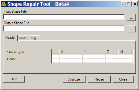
…I still don’t have a bad shapefile to test it with! If you try it, and it works for you, please let me know in the comments. Thanks!
Now that TIGER has officially moved to the shapefile format, the only TIGER data left in the previous format available on the Census website is the 2006 Second Edition data, and that’s likely to disappear at some point in the future. GIS@Vassar links to an announcement at ICPSR that they have TIGER data in the original format from 1990-2006 archived for download here. Convert it to shapefile format with the free version of tgr2shp, or to KML with tgr2kml.
“Waypoints”, geographic position markers created either in a GPS unit or using software, have been a function found on virtually every GPS unit ever made. More recently, “Points of Interest” or POIs have been implemented as an alternate way to store data for a point position, and many recent GPS units let you upload your own custom POI lists. POIs provide a handy way of organizing groups of points, and can also include more information on a point than a standard waypoint. I’ll be doing a short series of posts on creating and manipulating POIs. While the focus will be on Garmin GPS POI capabilities, other GPS manufacturers also support them as well, though usually in different formats. Note: As far as I know, only Garmin GPS units that use external data storage cards (like those listed in this post) can accept custom POI data.
Continue reading ‘Introduction To Garmin GPS Custom POI (Points Of Interest) Data’