blankblank blank


Archive for the 'data' Category Page 7 of 19


Excel Spreadsheet Data To Google Earth Thematic Map

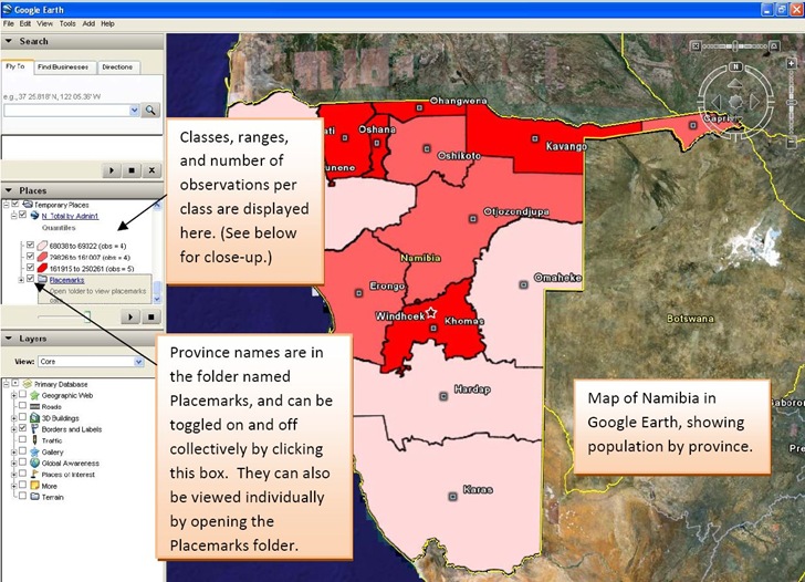
After yesterday’s post on thematic mapping in Google Maps, John Stewart  of the University of North Carolina’s MEASURE program wrote to tell me about their own thematic mapping tool, the E2G Thematic Mapper. This Microsoft Excel macro spreadsheet data and links it with polygon data for countries and their administrative units to create thematic maps for Google Earth:

Excel data to Google Earth thematic map

Image is from the excellent PDF manual included with the distribution. I can’t try it out because I don’t currently have a computer with Excel (2003 or 2007), and it doesn’t seem to run on Open Office Calc.

It also currently only has polygon data for sixteen countries:

  • Botswana
  • Côte d’Ivoire
  • Democratic Republic of the Congo
  • Ethiopia
  • Guyana
  • Haiti
  • Kenya
  • Mozambique
  • Namibia
  • Nigeria
  • Rwanda
  • Tanzania
  • Uganda
  • Vietnam
  • South Africa
  • Zambia

But John says that an update coming this summer will add polygon data for more countries, along with more macro features.

If you’re interested in field data acquisition, the entire Monitoring and Evaluation Systems section of the MEASURE site is worth a look.


Marine Navigation GIS Data

SM asks if I know “any free or commercial data source for boat landing or (boat ramp) sites…? I am especially interested in IL,IN,OH,and MI area.”.  My first idea was to check two US Government sources of marine GIS map data.

Continue reading ‘Marine Navigation GIS Data’


List Of Towns And Cities In A Country With Coordinates And Elevation

In a previous post’s comments section, someone asks if there’s “a way to filter for US cities (or world cities for that matter) that are between 3000 feet and 4000 feet elevation”. In order to do that, you need the data, and oddly enough there’s a specialized little application that can retrieve that data for world cities. GeoMaker (scroll down for the download link) lets you select from a list of world countries, then queries the NIMA (National Imaging and Mapping Agency) online database for the following:

  • City/town name
  • Geographical coordinates (latitude/longitude)
  • Region/State (if available)
  • Elevation above sea level (in meters)

You can also download a text file with NIMA gazetteer data as well for a particular country, but it includes all geographic features, not just cities, and can be enormous in size.

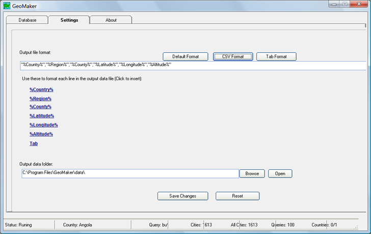
Output is in text format, in either “|”, comma or tab delimited formats, as specified in the Settings tab:
4-1-2009-8.17.26 PM

To retrieve the data, select the country you want the data for from the list on the main screen:

4-1-2009-8.20.42 PM

Click on the country name to select it, not the checkbox – clicking on the checkbox seems to select Afghanistan for every case in addition to the country you want. Once you’re selected the desired country, click “Start”, and the program will start querying the NIMA  database. It uses a brute force approach, where it queries for every possible set of 2-4 starting letters plus a wild card character. Consequently, the search may take quite a bit of time even for small countries, and will usually come up with duplicate entries.  Once complete, the output text file is saved in the “data” subfolder of the main program folder with a two-letter name descriptive of the country (e.g. “AF” for Afghanistan, “AO” for Angola).

You can open the text file in a spreadsheet and do a query or sort to find the information you need. If you saved it in CSV format, you could use a GIS program like MapWindow to convert it into shapefile format., and then query the attribute table. Source code for the app (Visual Basic 6) is also available at the download site.

For the United States, the program is supposed to use a different online database, but that doesn’t seem to be working right now. But a full install of MapWindow includes several sample projects; in the “United States” folder you’ll find the “cities” shapefile, which lists over 3000 US cities,  their elevation above sea level in feet, and other information. You can query this shapefile in a GIS program, or export it into spreadsheet format with Shape2Text.


The Blue Marble Navigator

NASA’s Next Generation Blue Marble imagery (available here) is a set of 12 monthly composite images of the entire earth, using 500-meter-resolution imagery from the MODIS satellite. The Blue Marble Navigator offers a convenient interface to view this imagery, along with several other useful options.

After selecting your initial location from a world map, the main interface comes up:

Continue reading ‘The Blue Marble Navigator’


Animated Cartograms Of World & USA Demographic And Economic Data

Mapping Worlds has created two sites for the USA and the world with animated cartograms, maps where the value of a parameter is used to adjust the drawn size of a geographic area. Here’s an animated cartogram showing military spending for world countries; click on the clockwise circular arrow on the map to have the countries resized based on their military expenditures:


Click on the Resize button (the counter-clockwise circular arrow at the upper left) to reset the countries to their original size. Repeat at will.

Data can be very timely; here’s a USA cartogram showing stimulus bill jobs by state:

Over 140 datasets are currently available with demographic, economic, trade, environmental, etc. data; you can also submit your own datasets for inclusion. Direct links are immediately available for every cartogram page, but you can also get images and embeddable code (like the examples above) emailed to you if you agree to Mapping Worlds’ Terms Of Use.


Web Application For Querying NGS Survey Marker Locations And Displaying Them In Google Earth

Not too long ago, I posted about DS World, a Windows app that lets you query a database of National Geodetic Survey markers, and returns a KML file to display them in Google Earth (note: earlier versions of DS World may have problems with Google Earth 5, but the newest one works fine). In comments, the survey firm of Metzger and Willard noted that they’ve created a web app called NGS Control Stations (NGSCS) Radial Search that performs a similar function. Despite the name, it allows search by three different areal selection methods:

Continue reading ‘Web Application For Querying NGS Survey Marker Locations And Displaying Them In Google Earth’


US Surname Maps

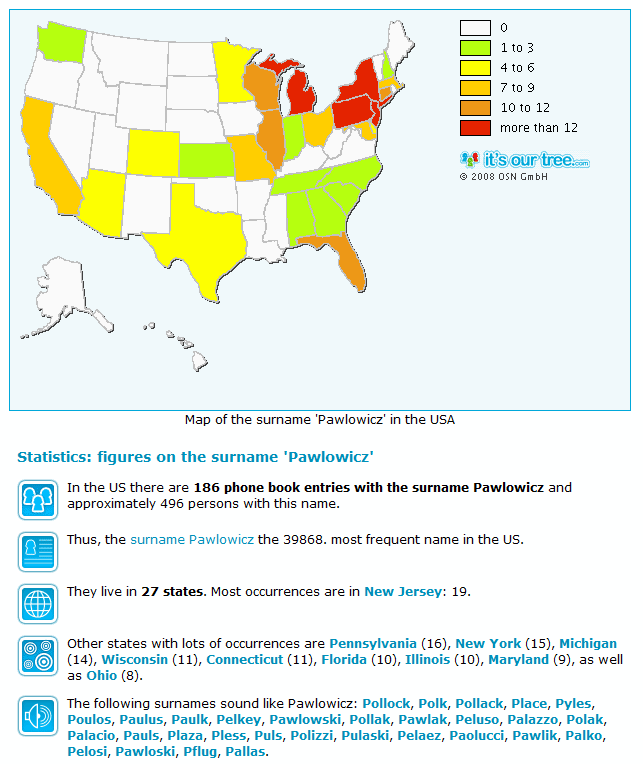
A while back, I covered the World Names Profiler, a program for plotting the population density for surnames for countries around the world. Dynastree Maps is a similar application for the US, Canada, and Germany, and includes additional information:

2-2-2009-12.11.20 PM

Note: Currently only works in Internet Explorer and Safari. I also get a Javascript error message, but it doesn’t seem to affect functionality.

Via Webware.


National Geodetic Survey Marker Positions And Info In Google Earth

The US National Geodetic Survey has produced DS World, a free program that can query their database for the positions of geodetic survey marker stations based on either state/county, distance from a fixed coordinate, or Project ID. It then produces a KML file with their locations and loads it into Google Earth. For example, to get county data, choose Stations => By State and County, then select the state and county from the successive dropdown menus that appear:

Continue reading ‘National Geodetic Survey Marker Positions And Info In Google Earth’