blankblank blank


Archive for the 'data' Category Page 13 of 19


New "Fixed" Versions Of SRTM-90 Data Available

SlashGeo has a post up asking for feedback and info about the various version of SRTM-90 data. SRTM was the Shuttle Radar Topography Mission, an instrument package aboard a 2000 flight of the Endeavour space shuttle that mapped the earth’s topography at a resolution of 30 meters using radar. While one of the most inclusive and comprehensive worldwide topographic datasets, SRTM has a few drawbacks:

  • The original data had many voids, holes and other irregularities
  • The SRTM radar registered buildings and vegetation as terrain, and added their height to the actual terrain height
  • Radar mapping has problems with dry sand (e.g. sand dunes)
  • 30-meter data has only been released for the US; for the rest of the world, the 30-meter data was re-sampled to 90 meters (hence, SRTM-90)

NASA has released SRTM Version 2, a “cleaned-up” version of the original SRTM data with holes and voids filled, and the data irregularities supposedly cleaned up; this data is available from the USGS Seamless Server. There are still problems with this cleaned data, like the mountain I viewed in Mexico that had a hole in its summit that went all the way down to sea level. I’ve been using my own version of SRTM-90, with holes in the original data patched using GTOPO30 data. But since GTOPO30 data has a resolution of 1 km, my solution was less than ideal.

The SlashGeo post and comments mention two attractive-sounding alternative versions of SRTM-90 data:

  • The CGIAR Consortium For Spatial Information has released Version 3 of their cleaned-up SRTM-90 data, using contour interpolation and alternate data sources to fix voids and holes. I looked at CGIAR’s Version 2 before, and wasn’t satisfied with it. I’ve taken a cursory look at some of their Version 3 compared to NASA’s Version 2, and while the CGIAR data still isn’t perfect, it looks better than the NASA Version 2 data (and also better than my patched data). But be prepared to have the downloads timeout on you, as happened to me on multiple occasions on the main site (haven’t tried the mirror download sites yet). There’s also a Google Earth file that offers a more convenient interface for viewing and downloading the data.
  • The USGS has developed their own “cleaned-up” version of the SRTM-90 data for use with the WWF’s HydroSHEDs program. Haven’t looked at these yet, but more information and download links are available from their website (I wasn’t able to successfully download any data – curse you, ArcIMS). Also, data is currently only available for Central and South America, a small part of the US, and parts of Asia and Oceania.
Caching TerraServer Imagery For USAPhotoMaps

USAPhotoMaps offers a convenient and easy interface to TerraServer imagery (USGS topo maps, aerial photography). But it’s still a pain to have to sit and wait for imagery to be downloaded for a selected area you haven’t looked at before, since the data for that area can’t be permanently cached on the hard drive until it’s downloaded. If there’s a geographical area that you know you’ll want to have data “on call” for, there’s a free utility that will pre-cache TerraServer image data from that area on your hard drive for fast future access and retrieval by USAPhotoMaps.

Continue reading ‘Caching TerraServer Imagery For USAPhotoMaps’


Georeferenced TerraServer Imagery With USAPhotoMaps

An earlier post described TerraClient, a program that lets you download large-area full-resolution USGS aerial photo imagery from the TerraServer website. That’s more convenient than downloading individual pieces from the USGS Seamless Server and then stitching them together, and has the additional advantage of letting you see the areas you’re selecting for download on-the-fly. But it has the disadvantage of producing images that aren’t “georeferenced”, i.e. they don’t come with the coordinate information needed to import and use them directly into a GIS viewer or editor.

There’s a free program called USAPhotoMaps that can create georeferenced TerraServer imagery for smaller geographic areas than TerraClient, and not just black-and-white aerial photos: it can also export georeferenced seamless color USGS topographic maps and high-resolution (0.15 to .65 meter) color aerial photos from selected urban areas. USAPhotoMaps has a far friendlier and faster interface than the USGS Seamless Server (which also offers this imagery in georeferenced format), and USAPhotoMaps has a bunch of additionalcapabilities that are easy and convenient to use. This post will deal with using TerraServer to view and export TerraServer imagery; its additional capabilities will be covered in future posts.

Continue reading ‘Georeferenced TerraServer Imagery With USAPhotoMaps’


UK Street Map And 12.5-cm Aerial Photography Web Service From 192.Com

Got an email from 192.com, a UK mapping website, announcing some new enhancements to the site:

  • Ordnance Survey Maps with all streets labeled
  • 12.5-cm resolution aerial photography
  • Journey planner

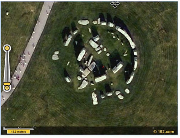
The interface is Flash, proprietary and a bit small in size, but useable. I’ll defer to any UK readers as to the quality of the OS maps, but the aerial photography is very impressive. Here’s shot of Stonehenge at maximum zoom, clearly showing individual visitors:

stonehenge

Note: There’s no separate settings for maps or aerial photography. As you zoom in, you first get OS Maps, and when you zoom in very close, it switches over to aerial photography. I tried three locations at random in the UK, and they all had high-res aerial imagery, so I’ll believe their claim that it covers the entire country.

192.com has other mapping service features, like people and address search, business search, local search, etc.. Doesn’t have all the capabilities of Google Maps, but the OS Maps and high-res aerial photography could make this a useful alternative to GM for UK residents.


Free 10-Meter UTM SDTS 24K DEMs

Among the highest quality DEM data you can get to go with a standard USGS 1:24K topo map is 10-meter SDTS DEM data, with heights specified to the nearest 0.1 meters (though the altitude accuracy of the DEM likely doesn’t warrant that resolution). I find it superior to the 10-meter NED data provided by the USGS Seamless Server, with fewer artifacts, although the SDTS format isn’t as well-supported as the DEM formats available at the Seamless Server. The SDTS DEMs are also in UTM NAD27, same as typical for USGS topo maps, versus the geographic projection for Seamless Server DEMs. There are a fair number of pay sites on the Web that offer these SDTS DEM files for a price, but there is one website where you can download them for free.

The GIS Data Depot has gone through some changes over the years, but is still around. It offers not just SDTS DEMs but a host of other GIS data, some free, other not free (you can often find the paid data for free elsewhere on the web). Data is classified as “statewide” or “countywide”, and you’ll find the SDTS DEMs in the “countywide” sections, listed in the Digital Elevation Models (DEM) – 24K section under the 1:24K topo map name whose area they cover (offered in both 10-meter and 30-meter resolutions) . The catch with the free “Normal” downloads is that they are at slower speeds than the paid “Premium” download (appears to be roughly 10 kilobytes per second or so).


Downloading Large-Scale Orthoquad Imagery From Terraserver

USGS digital orthoquads are black-and-white aerial photos covering most of the continental United States, with a resolution of up to 1 meter per pixel. You can download orthoquad imagery from the USGS Seamless Server as well as other online archives, but the maximum extent of individual images from those sources is limited; if you need an image covering a large geographical area, you’ll need to assemble them piecewise from smaller images. Terraserver also provides digital orthoquad imagery, and there are some programs that will download Terraserver imagery for small geographic extents, but not large ones at the full resolution of one meter per pixel. If you don’t need the imagery to be georeferenced, or can georeference it yourself later on, TerraClient lets you download digital orthoquads covering extents of tens of miles on a side at up to one meter per pixel resolution in a single image file (the maximum area covered depending on your computer screen resolution).

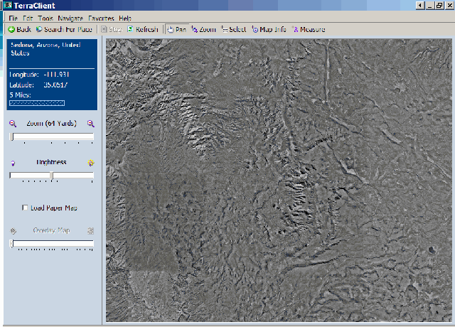
After installing and running TerraClient (see addendum at bottom concerning downloads), you select the center of your area of interest by either entering the coordinates directly, or using a search box that lets you center on gazetteer features like cities, bodies of water, peaks, etc.. After selecting the center location, TerraClient will zoom to that location, and load in Terraserver imagery at an on-screen resolution of 64 meters per pixel (it says yards, but Terraserver data is in meters).

TCoverview

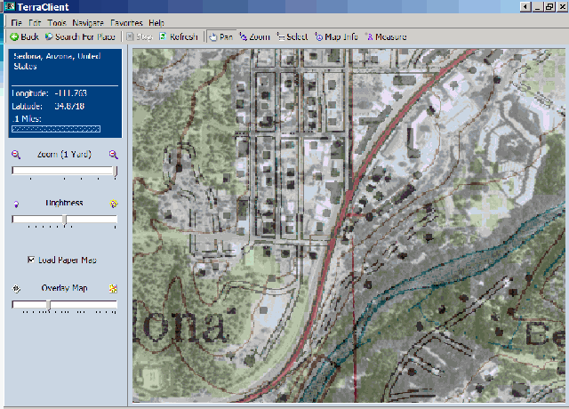
The slider controls in the left sidebar let you zoom in to up to one pixel per meter onscreen resolution, and also adjust the overall brightness of the image. Check the “Load Paper Map” box, and TerraClient will overlay a USGS topo map on top of the digital orthoquad, with the transparency of the map set by the bottom slider:

TCMerge

The controls at the top let you:

Pan – Move the image around by clicking and dragging

Zoom – Zoom in to an area by clicking and dragging on the map to select an area

Measure – Click on two points on the map, and find out the distance between them

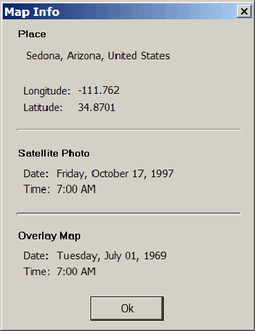
Map Info – Click on the map, and get an info window that tells you when the aerial photo (mislabeled “satellite”) was taken, and when the topo map dates from:

mapinfo

Select – You can use this to select an area to download an entire image from, but you can also use Ctrl-A (or Edit => Select All) to choose the entire on-screen image.

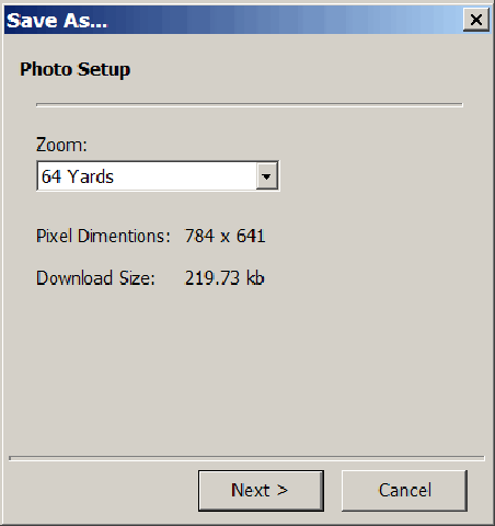
To create an image covering the widest area possible, you would set the zoom level to 64 meters, and then use Ctrl-A to select the entire image. Then choose File => Save As to get the save options:

PhotoSetup

Use the zoom dropdown to select the image resolution, and TerraClient will give you the image size in pixels, and the total download size for the data used to create the final image. For the example above, the image size and filesize are fairly small; but if I set the zoom to 1, the image dimensions mushroom to 50129 x 41022 pixels, and the download size is a whopping 446 MB. You will have the option to save the image in JPG form (smaller filesize, but degraded resolution) or BMP (full resolution, filesize essentially the same as the download size). If the download size is too large for your system’s resources, you’ll get an error message to that effect, and you’ll have to reduce either the zoom level or the size of the selected area.

I don’t need a large, non-georeferenced orthoquad image that often, but when I do, TerraClient is a convenient way to get it. But it’s also an easy way to find the date when orthoquad aerial photos were taken, along with the date of the overlaid topo map data, and the blending of topo map images with aerial imagery can also be handy. It would be great if the program allowed you to save blended images, but it doesn’t.

Tomorrow, I’ll start a series of posts on another free Terraserver imagery program, one which in many ways is more useful than TerraClient.

Addendum: In comments, Raj points out that the download link on the TerraClient homepage doesn’t work, and offers a Softpedia download link that does work. You can also download it from the BetaNews FileForum.


Data Overlays For Google Earth

OgleEarth posts about the King’s College Geodata portal, a terrific set of data overlays for Google Earth (static, network-updated, and temporal). Current datasets include:

  • Tiputini Biodiversity Station
  • Terrascope (new)
  • TRMM 2b31-Based Rainfall Climatology
  • Amazon-eye
  • Tropical montane cloud forests
  • MODIS Cloud climatology
  • SRTM SWBD Coast and water bodies
  • Petroleum-related impacts in the Amazon
  • AsterPAA (TerraLook) in Google Earth
  • GNS places database
  • Monthly NASA blue marble SG
  • Hole-filled SRTM 90m Digital Elevation Data
  • Sea level rise scenarios
  • Global forest change (2000-2005) from MODIS VCF
  • Three-hourly rainfall time series (from TRMM 3B42)
  • Monitoring Volcanoes
  • Urban climates
  • Tropical Hydrology : climate and land use impacts
  • Central American and Costa Rican Climate and Hydrology

And, of course, there’s a lot more similar datasets at the Google Earth Library.


Advanced Image Mosaicking With Regeemy

If I need to convert a paper map to digital format, and the map is larger than my scanner, I usually scan the map piecewise, and then mosaic the pieces back together into a single image. If I’m lucky, I can get the Photomerge feature of Adobe Photoshop to put all the pieces back together into a single whole, and get good matching at the edges. More often, though, Photomerge can’t get all the pieces to fit together, and I have to match up the sections manually using control points, which is a real pain. But I’ve found a program that automates the process of finding control points and mosaicking map sections, and produces far better results than Photoshop’s Photomerge function. It can also mosaic images shot at different angles and rotations (like satellite/aerial photos) and overlay images to look for temporal changes. If the first image is georegistered, it can automatically georegister the product mosaic image as well.

More after the jump ….

Continue reading ‘Advanced Image Mosaicking With Regeemy’