blankblank blank


Author Archive for Leszek Pawlowicz Page 9 of 79


LandSerf – Terrain Visualization And Analysis For Windows, Mac And Linux

I’ve been waiting for LandSerf 2.3 to officially come out of beta before posting on it, and that finally happened about a month ago. LandSerf is a Java-based GIS program with:

  • Terrain visualization and analysis functions (its primary focus)
  • Some vector functionality related to terrain analysis, plus other basic vector functions
  • GPS and Google Earth utilities

Today, I’ll walk through some of LandSerf’s basic terrain visualization and analysis functions; upcoming posts will deal with the vector and GPS/Google Earth capabilities.

Continue reading ‘LandSerf – Terrain Visualization And Analysis For Windows, Mac And Linux’


Early-Twentieth-Century Austro-Hungarian Military Maps Of Central And Eastern Europe

If anyone speaks Hungarian, perhaps they could translate the name of the site III. katonai felmeres for me. Fortunately, English text on the website explains what you find there: maps from the the 3rd Military Mapping Survey of the Austro-Hungarian empire, covering much of Eastern and Central Europe. The range covered goes from Istanbul in the southeast to Cologne in the northwest:

Continue reading ‘Early-Twentieth-Century Austro-Hungarian Military Maps Of Central And Eastern Europe’


Solid 3D Landscape Models From LandPrint

A bit of a departure from the usual posts, since this service is definitely not free. I just purchased a solid 3D landscape model from LandPrint.com and thought I’d review the creation process and the results, offer my opinion, and give some tips for getting the best results if you order your own.

LandPrint lets you select a square/rectangular section of the Earth’s terrain, and creates a small 3D model of that terrain along with your choice of overlays:

Continue reading ‘Solid 3D Landscape Models From LandPrint’


PLSS Converters For The Western United States With DLLs, Code

1.  The TRS-data site at Montana State University lets you enter PLSS data (Township, Range, Section, “TRS”) for one of 17 western US states (AR , AZ, CA, CO, ID, KS, MT, ND, NE, NM, NV, OK, OR, SD, UT, WA and WY), and get back the latitude/longitude for the center of that section. You’ll need to know the correct meridian for the TRS section you’re interested in; the same site has a map that you can click on that will bring up a datasheet with the meridian. It also will give you information about the point you clicked on like latitude/longitude, slope, aspect, roughness, nearby landmarks,etc., but the scale of the map is so small that most of this data isn’t terribly useful.

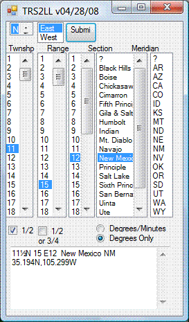
2. The site above uses Martin Wefald’s free TRS converter software, available for free download. This includes a DOS executable, DLLs for use in other Windows programs (including both TRS to lat/long and lat/long to TRS), source code, documentation and a sample Visual Studio app for TRS to lat/long conversion that functions similarly to the above website:
trs2ll

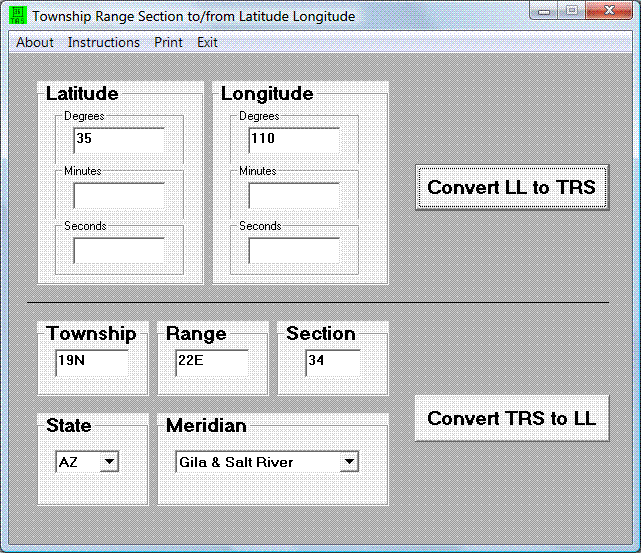
3. Paul Jorgensen has used these DLLs to create more stand-alone converters:

– A single-point app for converting TRS to lat/long, or vice-versa:
trs

– A bulk converter that takes a text file with TRS data, and outputs a text file with lat/long data. Documentation and download at this website. The format the input data needs to be in is very specific, so it might not be the easiest to work with.

4. While I’m on the topic: I’ve posted before about the Township And Range website, which takes TRS data and plots the location in Google Earth. Since the original post date, the author has added converters that will take TRS data and convert it to lat/long, and vice-versa, with the option to view the location immediately in Google Earth.

HT to Steve Richardson.


Convert TIGER Census Shapefiles (And General Shapefiles As Well) Into Thematic Google Earth KML Files

Bruce Ralston of the University of Tennessee has previously released several US Census TIGER data tools that I’ve posted about in the past. TGR2SHP converts TIGER files into shapefile format, while TGR2KML converts TIGER polygon files (like legislative districts and county subdivisions) into basic KML files for viewing in Google Earth. Both of these tools only work with the older pre-2007 TIGER format, which is no longer in use; the Census Bureau now issues all this TIGER data in standard shapefile format. But Bruce Ralston has just released a new tool called AFF Mapper that goes a step beyond his previous ones: it can convert TIGER shapefile data into KML format, link it to tabular American Fact Finder data (AFF) from the US Census, and plot this census data thematically. But unlike the previous TIGER tools, this one is a general-purpose one; it can convert any shapefile – point, line or polygon – into a thematic or unique value KML file, with the option of using thematic data from a linked external table. The only limitation is that the shapefile must be in geographic coordinates (lat/long), WGS84 datum, Google Earth’s native coordinate system.

I won’t go through the process with Census data; there’s an excellent PDF manual that describes the process of creating maps like this one (from the manual):

Continue reading ‘Convert TIGER Census Shapefiles (And General Shapefiles As Well) Into Thematic Google Earth KML Files’


New Free Stand-Alone MRSID Imagery Viewer/Exporter From LizardTech

A long time ago, LizardTech had a stand-alone viewer for MRSID imagery that let you export subsets of the image as TIFF files –  GeoTiffs if the original image was georeferenced. For some reason, that viewer was withdrawn as a free download in favor of a browser plugin, though you could still find the viewer available at some sites. I never really cared for the browser plugin, and kept my copy of their old viewer software safely stashed away.

LizardTech has just released GeoViewer 3.0, a new stand-alone viewer for georeferenced imagery, and a replacement for their $299 GeoView Express product. Note: The initial download is only 670KB, but that’s not the full program; it’s a front-end that downloads the 21 MB installer from LizardTech, so you’ll need a working Internet connection to install the software. It can read:

  • MRSID
  • JPEG 2000
  • GeoTiff
  • ERDAS Imagine
  • ECW
  • Express Server Layers
  • WMS Layers
  • JPIP Layers

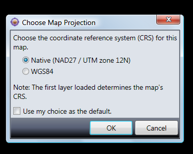
… and a bunch more, including vector shapefiles. It also opens JPEG and BMP imagery, and unregistered TIF images, but since it doesn’t seem to be able to use associated UTM worldfiles to register those images, it’s not clear how useful that is. If coordinate system data is embedded in the imagery, it uses the first file to set the native coordinate system, and re-projects successive files to match that native system. If that first file imagery is not in geographic coordinates (lat/long) and WGS84 datum, you’ll also have the option of re-projecting it immediately to lat/long, WGS84:

5-26-2009-9.34.06 PM

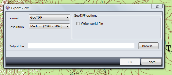
You can export either all the loaded data, or just the data in view, as a GeoTiff (Tools => Export), a raster PNG with worldfile, or JPEG with worldfile, in your choice of resolutions, using the Tools => Export menu:

5-26-2009-9.24.20 PM

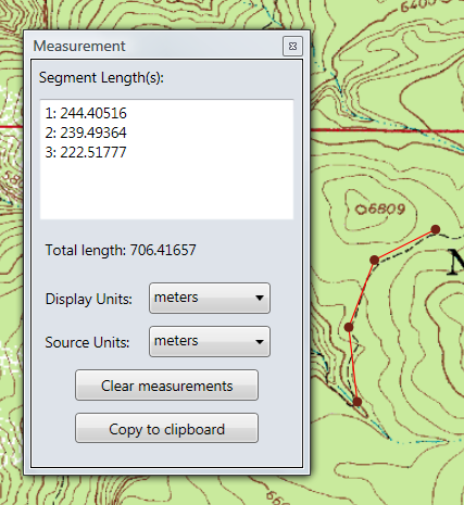
It also has a path measurement function, which works but is nothing to write home about:

5-26-2009-9.26.48 PM

You can load in multiple layers and mosaic them, and set layer transparencies, but you’re probably better off using other software for that. Really, the big thing about this program is that there’s now an up-t0-date, stand-alone MRSID viewer and imagery exporter from the company that created the format, LizardTech.

Via GISUser.


Online Photo Geotagging With GeoImgr

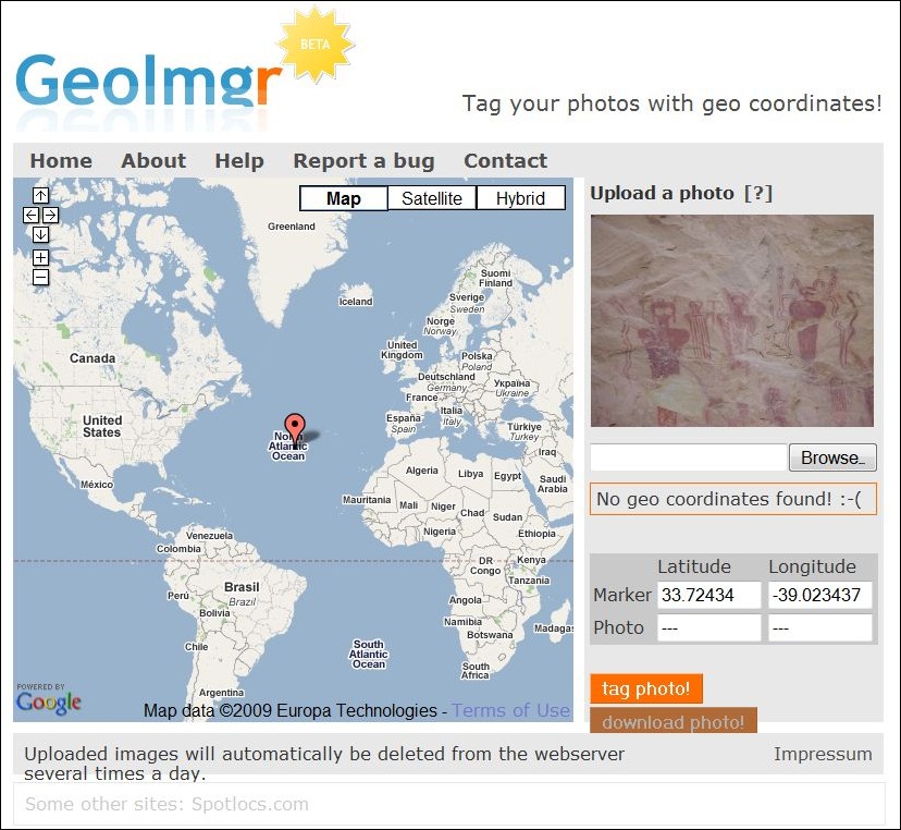
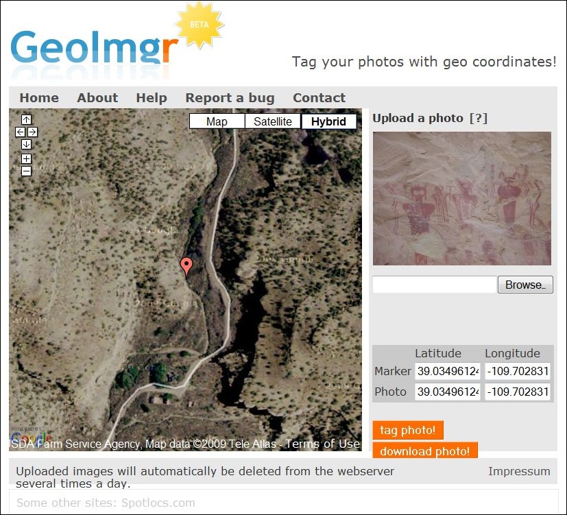
I’ve covered a fair number of stand-alone geotagging apps before; check the geotagging category on this blog for some examples. But if you don’t have a geotagging application on the computer you’re using, GeoImgr is a web-based app that can geotag photos with a simple Google-Maps-based interface. First, upload a single picture (no batch uploading, unfortunately). GeoImgr lets you upload the image at its full original resolution, so this can take a few seconds. Once uploaded,  a thumbnail of the uploaded photo will appear at upper right:

geoimgr1

Then position the marker in the Google Maps interface at the location where the photo was taken.  Click and drag to move the map, zoom in by clicking the plus button or double-clicking on the map, and position the marker with a single click:

geoimgr2

The position of the marker will be continuously updated at right; click on “tag photo!”, and those marker coordinates will be embedded in the photo’s header. When you click “download photo!”, the geotagged photo will be downloaded with its original filename intact, and the image data unmodified.

Not a substitute for a good stand-alone app, but does the job, easy to use, and always available online.

HT to Michael Kempf (creator of the site).


Simple Google Earth Image Enhancement With SpaceEye

SpaceEye (direct download link)  runs simultaneously with Google Earth, and lets you perform simple image processing functions on the imagery visible in the Google Earth window. After installing and running the program, it first starts up Google Earth in a partial screen window, then starts itself up either side by side with Google Earth, or overlapping it as in this case:

Continue reading ‘Simple Google Earth Image Enhancement With SpaceEye’