Modeling and calculating earth’s climate, with the many parameters involved (sun, atmosphere, land, water, snow/ice, etc.), used to be the exclusive domain of supercomputers, and still is for the most complicated models. But there’s a simplified computer climate model available for free for both Windows and Macintosh that lets you run climate models on a desktop PC, and allows you to investigate both past and future climatic scenarios.
Continue reading ‘Calculating And Mapping Climatic Change With EdGCM’
A nice tool that lets you create an embedded Google “My Maps” map, along with a KML file, on any web page.
Via Mapperz (which has an example) via Education/Technology (with another example).
I’ve been meaning to post about this site for a while, and it’s natural to do so after posting about GE-Path. The Geo Utilities website offers online tools that let you simplify KML files by reducing the number of points, create buffers (areas around a point, line or area of a specific size), calculate polygon areas, and determine the intersection location of two different layers.
Continue reading ‘Online Google Earth Utilities For Buffering And Area Calculations’
Frank over at Google Earth Blog was nice enough to link to my post last week about GE-Graph. In his post, he describes another great Google Earth utility from the same author that I was also planning to post on, and here it finally is.
Continue reading ‘Drawing Grids, Paths And Polygons In Google Earth Using GE-Path’
Other mapping sites seem to be doing an Earth Day related post, so I’ll move this one up a bit. Energy production from the heat of the earth (geothermal energy) generates no carbon dioxide emissions that contribute to global warming, and could produce as much as 100,000 megawatts in the US alone by the year 2050. Here are some websites with geographic geothermal data, both maps and downloadable data.
Continue reading ‘Geothermal Resources Data’
If you print your own maps, at some point you may need to take them out in the field, where they’re subject to wear, tear, abuse, spills, weather, etc.. But there are a number of brands of waterproof paper available that are more durable and tear-resistant than regular paper, and also provide some degree of protection from weather and spills. Brands are available for both inkjet and laser printers (caution: if you put some inkjet paper brands into a laser, they melt!). They’re not perfect; while the paper is waterproof, you can still get some bleeding with some inkjet prints if you don’t wipe the water off right away (not a problem with laser prints). And you can’t write with pencil on some of these papers – a waterproof pen is recommended for best results. Do a Google search for waterproof paper, or visit the Waterproof Paper website to see what’s available.
The mapz blog has a great post on mapping-related extensions for Firefox 2.0, and a single extension you can download and install that incorporates all of them.
Once again via Ogle Earth, a nifty little tool called Elevation Mapper. Enter two positions in Google Maps, either by typing them in or clicking on the map, and get an elevation profile between the two:
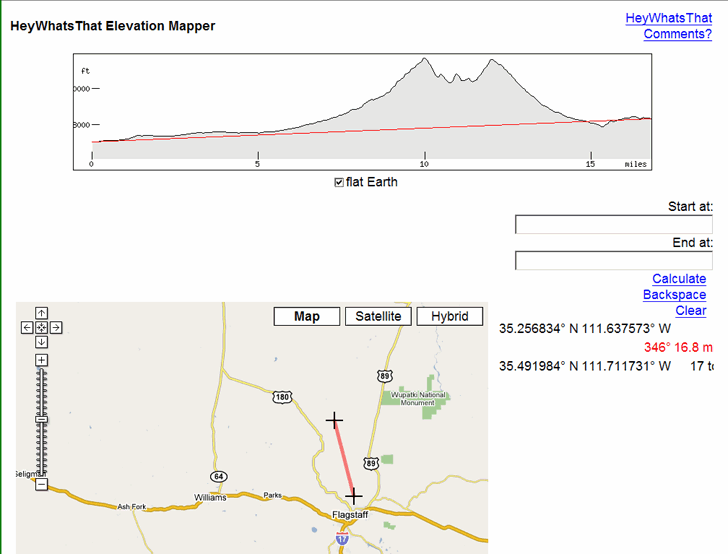
Counterintuitively, the “flat Earth” box needs to be checked for this to work.
If you have a DEM (digital elevation model) for an area, you can create a similar profile using 3DEM, either for a straight line or an arbitrary line/GPS track. With a high-resolution DEM, this would give you a more accurate profile.

