

A useful collection of links to map symbols is the Unofficial Arc/Info & ArcView Symbol Page. While some of the links are strictly for ArcView palettes and ArcInfo line and marker sets, a fair number link to graphic symbols and TrueType Fonts useable in any compatible GIS or mapmaking software. Symbol sets cover a wide variety, including roads and highways, geology, and animals. Most, but not all, are free. Also check out the links at the bottom of the page to free clip art resources.
Author Archive for Leszek Pawlowicz Page 63 of 79
A screen capture utility is a useful program to have for capturing map images off of web pages, or map displays in programs that don’t offer the capability to save the display as a graphic image. There are lots of them around, but I like mine to be simple, fast, and unobtrusive. My favorite is HoverSnap:
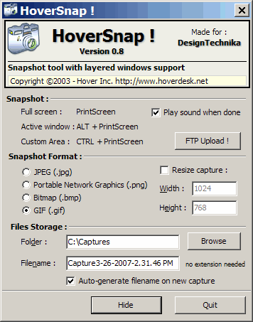
There’s no installation program, just unzip and run it. Clicking on the “Hide” button at the bottom minimizes it to the system tray; clicking once on the icon brings the options window above back. At the bottom, enter the default folder where you want the screen captures to be saved, and a filename to save them under. I recommend checking the “Auto-generate filename …” option, as this will append the date and time to the filename; otherwise, every successive capture will overwrite the previous one. You can save in JPEG, PNG, BMP or GIF formats, and either save at the current resolution or resize the captures to a specific pixel dimension.
When the program is running, pressing the “Print Screen” key saves the entire screen, Alt-Print-Screen saves the active window, and Ctrl-Print-Screen turns the mouse cursor into a crosshair that you can use to select a custom rectangle on the screen for saving by clicking and dragging. As a bonus, the download page for HoverSnap also includes free downloads of some other useful utilities, including a registry cleaner and an IP utility.
For a program with a few more options (more graphic file formats, ability to capture the mouse cursor image, custom capture keys), you might try Gadwin PrintScreen.
If you need to identify a township or section on map, or plot Public Land Survey Systems (PLSS) boundaries, you can get this data from the Land Survey Information System website, managed by the BLM. Shapefile data is available for most of the US, grouped by state and/or county, in the NAD83 datum. File data includes township, section, subsection, latitude/longitude, and metadata. Note: Make sure you have pop-ups enabled.
There’s also a Township Geocoder web form. Enter the latitude and longitude of the point you’re interested in, NAD27 or NAD83, and get back the state, principal meridian, township, range, section, quarter section, and quarter-quarter section. Or enter the previous data, and get back a latitude/longitude. You can enter individual points, or upload a file for batch point conversion.
Yesterday’s post dealt with the basics of installing MicroDEM, and opening up DEM terrain files in the program. Now it’s time to look at different ways to display terrain reflectance in DEM. While 3DEM is better for some kinds of displays, MicroDEM has more different ways to display reflectance.
Continue reading ‘Modifying The Terrain Reflectance Display In MicroDEM’
I see the occasional odd posting on boards asking about free GPS fleet tracking software; stumbled across this, and thought it worth posting about. OpenGTS, which stands for “Open GPS Tracking System”, allows web tracking on Google Maps for a fleet of vehicles. It’s written in Java, and uses MySQL, so it should run on any platform that supports those. Current version is available at the SourgeForce page for the project. The software is labeled “alpha”, and I have no way of trying it out, so you’re on your own on this one. If you do use it, please post your experiences in the comments section.
As you might guess from the name, MicroDEM is a program that works with digital elevation models (DEMs), plots of elevation as a function of position, the same kind of data used by 3DEM. But MicroDEM contains far more features and capabilities than 3DEM, and includes other non-DEM related features as well. I like to think of MicroDEM as a “Swiss army knife”, since it contains so many interesting and useful tools. Even if you’re not into GIS, MicroDEM is worth looking at for its terrain visualization and analysis capabilities. I could post for month or two on just MicroDEM alone, and by the time I’m done, the posts will likely add up to at least a month’s worth. But to start, I will do a number of posts over the next week or so on just a little of what MicroDEM can do. Bear with me on the first few – I have to get through some of the basics of program installation and operation before I can get to the really cool stuff.
Continue reading ‘MicroDEM: A Swiss Army Knife Of Terrain And GIS Tools’
There’s a new service from the USGS that lets you download 1:24K, 1:100K and 1:250K topo maps for anywhere in the US in GeoPDF format. It has an easy-to-use interface based on Google Maps that makes finding your location, and downloading the desired maps in compressed zip format, straightforward.
Continue reading ‘Downloading USGS Topo Maps In GeoPDF Format, And The GeoPDF Plug-In’
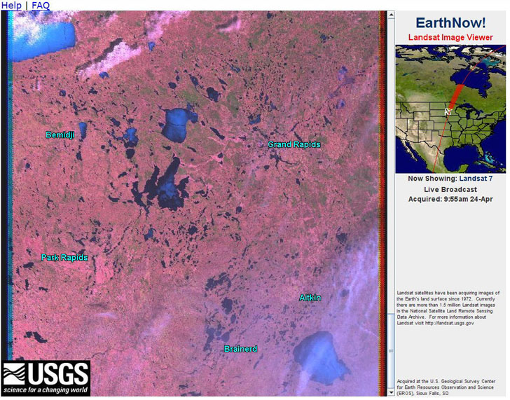
Honest-to-God (almost) real-time satellite data from the EarthNow! viewer. The catches are that it’s low-resolution (250-meter) Landsat data streamed from the satellite to your computer screen, so you only see the area the satellite was above recently. And since the image data is constantly scrolling across the screen, the only way to save an image is to do a screen capture. Still, fun to watch (click on the image below for a larger view, showing part of Michigan):
Via AllPointsBlog.
Edited 4/25 to change the resolution from 30 meters (which is what processed Landsat band data is) to the correct number of 250 meters. Also, it’s not really “real-time”, but almost.