The European Petroleum Survey Group (EPSG; now defunct, and superseded by the OGP Surveying and Positioning Committee) created and maintains a spatial reference database, assigning EPSG code numbers to spatial reference systems (combinations of coordinate systems, projections, and datums). There really is no way to figure out the spatial reference system from just the code number alone, or vice versa, so you need to look them up. The official database is in Microsoft Access format, not terribly easy to use; the code list in tabular format isn’t much better. There’s now a convenient online version of the database, searchable by keywords or code number. You can then access additional information for that spatial reference system in a number of different formats:
- Human-Readable OGC WKT
- Proj4
- OGC WKT
- JSON
- GML
- ESRI WKT
- USGS
- MapServer Mapfile
- PostGIS spatial_ref_sys INSERT statement
Users can also upload their own spatial reference definitions, which I suppose is a good thing as long as you exercise caution in using them.
Via import cartography.
Not as useful as it was before Google Maps MyMaps came along, but quikmaps.com has many of the features that MyMaps does, and a few it doesn’t:
– Draw lines on a map, either with line segments or arbitrary freehand (no polygons, unlike MyMaps)
– Add points to the map using a larger variety of full-color icons than MyMaps
– Add text labels directly to the map (not in MyMaps)
– Embed the map and your content in your website
– Export the map data directly into either KML format or GPX format for downloading into your GPS
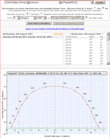
Select a geographic location by continent, country and city, and SunPosition.Info will give you a table of the sun’s azimuth and altitude during the day, as well as a plot of its position in the sky:
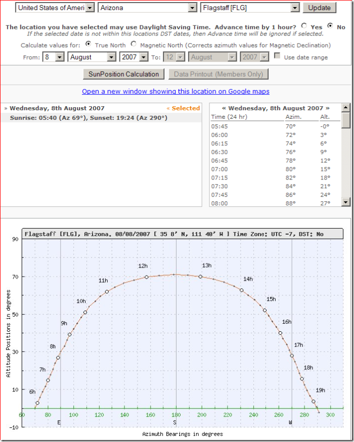
The stand-alone application MicroDEM can generate similar data, and if you have a digital elevation model (DEM) loaded, can tell you if the sun is blocked by local topography.
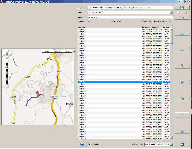
Just posted about RouteConverter, a Java-based GPS route/track manager, last Friday, and Christian has already updated it:
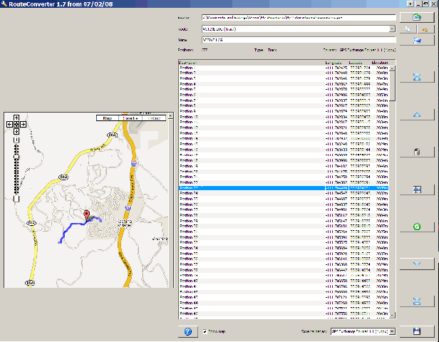
– The updated version for Java6 now includes a Google Map interface that displays the GPS track/route and the selected point position:
– There’s an executable for Windows, as well as a standard Java6 .JAR file for Windows and Linux
– A Java5 version with fewer features, but which is compatible with Macintosh, Windows and Linux
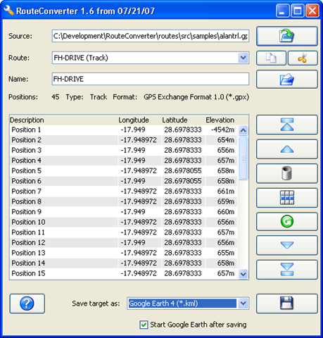
Christian Pesch has let me know about RouteConverter, his Java-based program for handling, editing and converting GPS routes. It requires Java 6, so it currently runs on Windows and Linux (no Mac). It lets you:
- Convert between different GPS route formats; currently supports:
- Garmin MapSource 5.x (*.mps)
- Garmin MapSource 6.x (*.gdb)
- Garmin PCX5 (*.wpt)
- Google Earth 3 (*.kml and *.kmz)
- Google Earth 4 (*.kml and *.kmz)
- Google Maps URL
- GPX XML 1.0 (*.gpx)
- GPX XML 1.1 with Garmin Extensions (*.gpx)
- Magellan MapSend (*.wpt)
- Microsoft AutoRoute 2002-2006 (*.axe)
- Motorrad Tourenplaner (*.bcr)
- Navigon Mobile Navigator 4 (*.rte)
- Navigon Mobile Navigator 6 (*.rte)
- NMEA 0183 Sentences (*.nmea)
- Tom Tom Route (*.itn)
- Tom Tom POI (*.ov2)
- Tour Exchange Format (*.tef)
- Add/subtract/edit points in a route
- Selects points within a certain distance of another point, and lets you delete them for route simplification
- Append a route to the current route
- Supports multiple routes within Google Earth, GPX and Garmin MapSource files
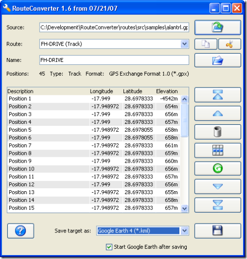
Screenshot (from the website):
A good supplement to ITNConv, since it handles multiple routes better than that program, is able to simplify routes, and also supports a few formats (NMEA, Tour Exchange) that ITNConv doesn’t. But ITNConv also handles some formats that RouteConverter doesn’t, and its Google-Maps-based editor for points is definitely a plus.
TerraClient offers a fast and simple way to get TerraServer black-and-white aerial imagery covering large areas, but with no georeferencing data that lets it be used directly in a GIS. USAPhotoMaps offers a convenient and easy interface for downloading TerraServer topo and aerial imagery of smaller areas, with georeferencing data in worldfile format. But the USAPhotoMaps images are saved in JPEG format resulting in some minor image quality degradation, and the worldfile data doesn’t include information like the coordinate system and datum. For that, you’d want to have the TerraServer imagery saved in a format that embeds georeferencing, coordinate system and datum into the actual file format, like GeoTiffs. MicroDEM offers the ability to download TerraServer imagery and then save it in GeoTiff format. While the process and interface are a bit more convoluted than that for USAPhotoMaps or TerraClient, it’s not too bad.
Continue reading ‘Creating GeoTiffs From TerraServer Imagery With MicroDEM’
I’ve been meaning to post on the MyMapsPlus website for a while; they offer a simple tool for embedding a Google Maps MyMaps page on your own website, similar to this one I posted about a while back. Just as well I waited – they have a more advanced site out now called MapChannels that lets you do a lot more:
- Instead of just displaying a single MyMaps KML file, you can display multiple Google MyMaps KML files as channels that can be turned on and off, like layers.
- GeoRSS feeds can be incorporated as channels as well, along with search channels (like Wikipedia).
- Filter map markers by category
- Define custom marker icons for a specific category
- Scripts can be hosted remotely at the MapChannels site, or remotely at your site; remote hosting lets you create full-screen maps
- Include driving directions, traffic overlays and local search
All for free, but they offer a paid service for developing special customized maps or features (check the About section for more information). Not a lot of documentation now apart from some basic tutorials, but that will probably come with time.
USAPhotoMaps has built-in GPS interface capabilities for Garmin GPS units; it also supports the general NMEA GPS interface for other units. While there are a lot of GPS functions, they’re a mixed bag. Waypoint creation, export, and import on the fly are pretty easy (with some minor quirks), and USAPhotoMaps is my program of choice for quickly creating waypoints on a topo map or aerial imagery and then exporting them to my GPS unit. Saving and manipulating waypoint data is more problematical, and dealing with routes and tracks is a major headache. It seems as though some of these features were bolted on rather than integrated with the main program in a logical fashion. My experiences were with a Garmin GPS (60Cx); YMMV.
Continue reading ‘USAPhotoMaps: GPS Functions’