blankblank blank


Archive for the 'KML' Category Page 12 of 16


Geotagging Photos With iTag

Ogle Earth has done posts on using Picasa to geotag (aka geocode) photos in both the stand-alone version of Picasa, and online in PicasaWeb albums. There are a fair number of other stand-alone programs for geotagging photos in a wide variety of ways, many of which include other useful features (like inserting the photos into Google Earth or Google Maps). Over the next few weeks, I plan to review a fair number of these programs on this blog.

First up is iTag, an IPTC tag installer. Its principal function is to add title, description and keyword tags to photos, but it does have some geotagging capabilities. iTag opens entire folders with pictures, and displays their contents in thumbnail format:
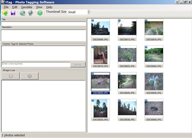
itag.jpg

If your photos are already geocoded, iTag can create placemarks with a photo thumbnail bubble in Google Earth, though this can take a while depending on how large the photo size is:
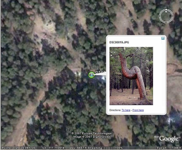
itagge1.jpg

You can save the placemark from Google Earth, but iTag also lets you create a KMZ file with the photo (or photos) embedded directly in the file, or linked to an internal or external location.

Geotagging a photo or group of photos is a multi-step process. You need to first create a placemark at the desired location in Google Earth. iTag’s default geotagging process is to take KML placemark data copied into the Window’s clipboard (right-click on the placemark and choose Copy), and use the geographic data embedded in that to geotag the photos. You also have the option of using a saved KML placemark file to geotag the photos. I prefer Picasa’s method of geocoding the position directly in Google Earth by selecting the photo in Picasa and then choosing the position with a cursor in Google Earth, but there may be occasions when iTag’s placemark process might be more convenient.

iTag lets you copy EXIF GPS data to the IPTC tags and vice versa, and also erase the geographic data completely from the photo. It also can convert GPX waypoint files to KML, so that you can use individual GPS points to geotag your pictures (but there are better ways to do this that will be covered in future posts).

iTag is a convenient way to apply descriptive tags and keywords to a photo or group of photos, better than the Picasa IMO because that’s all it does. The geotagging capabilities are a convenient bonus, but here I think Picasa is easier to use in most (if not all) cases.


Update For Online Google Earth Utilities

Juan Garcia writes to say that his Geo Utilities website has been updated. I’ve posted about this site before; it has a number of tools for Google Earth KML files, including:

  • Simplification (reduction of the number of vertices
  • Buffering
  • Area calculation
  • Topology (find the intersection points between a path and the perimeter of a polygon)

Updates include modification of the algorithms to speed them up, and a download link to the source code, released under the GPL.


EarthPlot Software Tools For Google Earth

Back in 2005, EarthPlot software released several shareware tools for plotting data and creating graphic overlays in Google Earth. The most recent versions of their software are now available as freeware. If you’re interested in plotting spreadsheet data or creating annotated overlays in Google Earth, you should definitely check these out.

More after the fold …

Continue reading ‘EarthPlot Software Tools For Google Earth’


Adding Color Transparency To GIF/PNG Google Earth Image Overlays

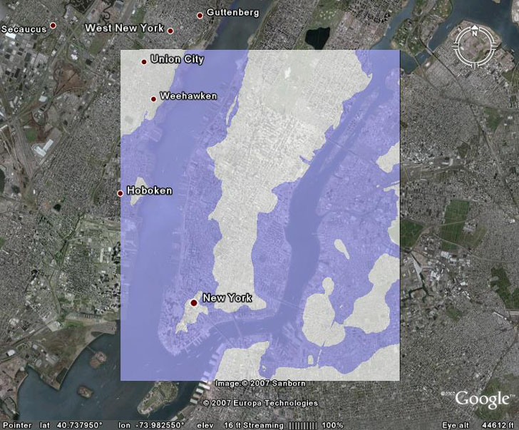
In the last post, a raster image overlay of 8 meters of sea level rise flooding was loaded and positioned into Google Earth:

overheadview1

But the white areas of the original raster image obscure the underlying aerial photography, even when the raster image is made partially transparent. It would be useful to make that original white area completely transparent, while preserving the blue areas that represent areas flooded by the sea, and that can be done in Google Earth.

Continue reading ‘Adding Color Transparency To GIF/PNG Google Earth Image Overlays’


Image Overlays In Google Earth

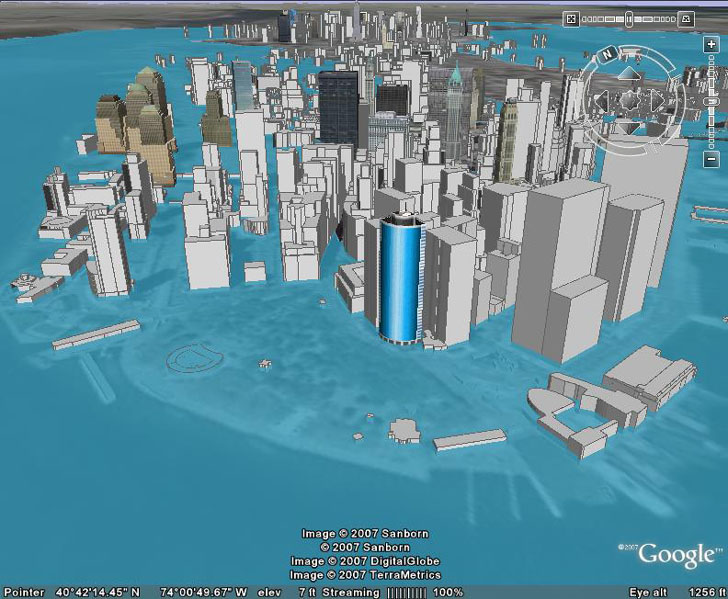
In a previous post, a vector-based KMZ file was created to show the effects of 8 meters of sea level rise on the Manhattan area:

manhattanafter1

If you read the earlier post, you’ll see that it’s a fairly convoluted process to convert a raster graphic image into a vector KML format, involving multiple steps that may not be that straightforward for a GIS newbie. But there’s an alternative path: take the original raster graphic image, and import that into Google Earth as an image overlay. This post will show specifically how to do that for the sea level rise image, but the process can be used with any generic image overlay.

Continue reading ‘Image Overlays In Google Earth’


Update On GooPs – Real-Time GPS Tracking In Google Earth

A while back, I posted on GooPs, one of a number of options to feed GPS data directly to the free version of Google Earth, lessening the need to spend $20 on Google Earth Plus, while getting fewer features. Today, a Google Earth Blog post indicates that GooPs has gone through some recent updates and changes.

1. A new website for GooPs.

2. Before, GooPs was donationware; now there is a fully free version, and Plus/Pro versions that offer more features for $9.95 and $19.95 respectively. Here’s the features chart from the website:

  GooPs Free GooPs Plus GooPs Pro
Fast real-time tracking * * *
Remote Tracking Two vehicles Five vehicles Unlimited
SpeedTrack   * *
AutoView   Pre-configured Fully Configurable
Classic 3D Cursors * * *
Image Cursors * * *
Lifelike 3D Model Cursors     *
Real-time tracks * * *
TimeStamps   * *
PointMarkers     *
Record/Playback NMEA Log     *
Native Google Earth View Control * * *
Integrated FTP Client * * *
Save trip to Google Earth * * *

The integrated FTP client is especially cool – if you have a live Internet connection, you can continuously upload your position to a “live” link, letting others track your live position in Google Earth. DestinSharks had done that as part of a weekend boating run.

Functionally, the program doesn’t seem to have added any major features since I last posted about it (except maybe your choice of 3D cursors). Still, it’s one of the best free options, and the paid versions are cheap and offer useful additional features.


Convert A Google Maps Point To Multiple Text Geographic Formats

There’s a handy Google Maps site that lets you place a marker, gives you the position, and then lets you convert that position into a number of geographic text formats.

Continue reading ‘Convert A Google Maps Point To Multiple Text Geographic Formats’


A Few More Free Toolsets For ArcGIS

Another in a series of posts on free toolsets for ESRI products. Today’s sets comes from Valery Hronusov, author of such useful paid tools as SuperOverlay (a stand-alone program for creating tiled raster image datasets for Google Earth), and KMLer (an extension for ArcGIS that exports data in KML format). The free tools are only for ArcGIS, versions 9 and higher.

Continue reading ‘A Few More Free Toolsets For ArcGIS’