blankblank blank


Archive for the 'KML' Category Page 11 of 16


A KML To CSV (And CSV To KML) Converter For Spreadsheets And Garmin POI Files

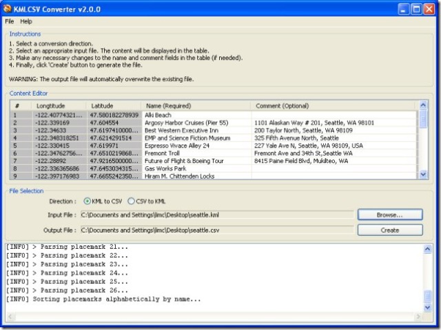
Newer Garmin GPS units support the upload of sets of POIs, containing both position data and descriptions of the Points Of Interest. The KMLCSV Converter is a Java application that lets you convert placemarks created in Google Earth and saved as a KML file into a CSV (Comma-Separated Values) file compatible with Garmin’s POI Loader; this CSV would also be compatible with most spreadsheet programs as well. The process is straightforward:

1. Create placemarks in Google Earth using the “Add Placemark” tool, search, or other means.

2. Add a description to the placemark.

3. Drag all the placemarks you want to save into a single folder.

4. Save the folder as a KML file

5. Convert it to a CSV file with the KMLCSV Converter Program (screenshot from website)

screenshotkmlcsv

6. Upload the CSV POI file to your Garmin with the POI Loader program, or into your spreadsheet as a standard CSV file.

There’s a short PDF tutorial file that covers these steps quite clearly with screenshots.

You can also convert CSV files, either POI files or spreadsheet files created by yourself or someone else, into KML files for viewing in Google Earth; a search for “Garmin POI” files on the web will bring up links to many sources, both free and paid. But I prefer the program csv2kml for that purpose.


Prune – Java-Based GPS Track Visualization And Photo GeoTagging

Prune is another Java-based GPS tool with its own unique set of features, including:

– Load multiple text, GPX or KML tracks, appending them to each other

– Trim duplicate points, and compress the track (hence the name Prune)

– Save combined tracks in text or KML format (use GPS TrackMaker to convert the KML tracks to GPX format if desired)

– See a plot of position, and altitude if available

Continue reading ‘Prune – Java-Based GPS Track Visualization And Photo GeoTagging’


Draw/Label On Google Maps, And Generate GPX/KML/Embeddable Maps

Not as useful as it was before Google Maps MyMaps came along, but quikmaps.com has many of the features that MyMaps does, and a few it doesn’t:

– Draw lines on a map, either with line segments or arbitrary freehand (no polygons, unlike MyMaps)

– Add points to the map using a larger variety of full-color icons than MyMaps

– Add text labels directly to the map (not in MyMaps)

– Embed the map and your content in your website

– Export the map data directly into either KML format or GPX format for downloading into your GPS


Advanced Tool For Embedding Google Maps MyMaps On Your Website

I’ve been meaning to post on the MyMapsPlus website for a while; they offer a simple tool for embedding a Google Maps MyMaps page on your own website, similar to this one I posted about a while back. Just as well I waited – they have a more advanced site out now called MapChannels that lets you do a lot more:

  • Instead of just displaying a single MyMaps KML file, you can display multiple Google MyMaps KML files as channels that can be turned on and off, like layers.
  • GeoRSS feeds can be incorporated as channels as well, along with search channels (like Wikipedia).
  • Filter map markers by category
  • Define custom marker icons for a specific category
  • Scripts can be hosted remotely at the MapChannels site, or remotely at your site; remote hosting lets you create full-screen maps
  • Include driving directions, traffic overlays and local search

All for free, but they offer a paid service for developing special customized maps or features (check the About section for more information). Not a lot of documentation now apart from some basic tutorials, but that will probably come with time.


Photo GeoTagging IV – GPicSync

The last photo geotagging application I’ll cover for now is GPicSync, freeware from Francois Schnell. This application doesn’t have as fancy an interface as PhotoMapper, locr or Location Stamper, but it has some useful, and unique, features:

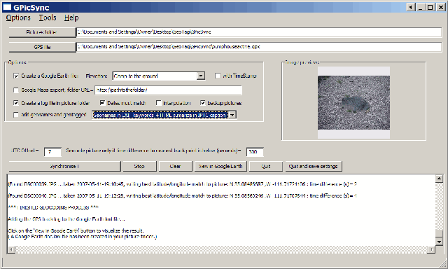
  • It just works, cleanly and neatly. Set the locations for picture folder and the GPS file (GPX or NMEA), set the correct time offset between local time and UTC (aka GMT), and click the Synchronize button to geotag the photos.

GPicSync

  • Pictures geotagged by GPicSync are recognized by Picasa right away; no need to re-process them with EXIFTool.
  • You can create a Google Earth/Google Maps KML thumbnails file at the same time you’re geotagging the photos. You can also associate audio and video files with the pictures, so that GPicSync will create links in the Google Earth / Google Maps files that link to the audio/video.
  • Handy tools include an EXIF reader, a utility that lets you manually embed geographic location into the EXIF header, a GPX file reader, and KMZ file generator to create a Google Earth file with the photo thumbnails embedded in it (unlike the KML file).
  • And there’s a newsgroup where you can interact directly with the program author, report bugs, and suggest new features.

Thanks, Francois!


Exporting KML Data From Google Maps MyMaps To A GPS

AnyGeo and OgleEarth both post today on TakItWithMe, a new free web service that lets you upload Google Maps MyMaps KML data directly from your browser to a GPS unit. It’s limited now to Garmin units, since it relies on the Garmin Communicator plugin. And while the device support page indicates that some serial interface GPS receivers will work, Garmin says that it works best with USB devices, and doesn’t promise good serial support.

For other GPS manufacturers, and for KML files created in Google Earth or by some other means on your local computer, I’ve posted before about a number of free ways to upload KML file data into a GPS unit:

Exporting Data From Google Earth To A GPS Unit
Using GPS Utility To Import/Export GPS Data To/From Google Earth
GPS Trackmaker: A Better Solution For GPS Export/Import With Google Earth

There’s another way for Garmin units, but I’m waiting until it’s out of beta to post on it ….

Addendum: Google Earth Blog points out that TakItWithMe can also convert KML files to GPX format, so that you can upload them to a non-Garmin GPS using any program that accepts GPX, like EasyGPS or GPS Trackmaker.


Photo GeoTagging II – Locr

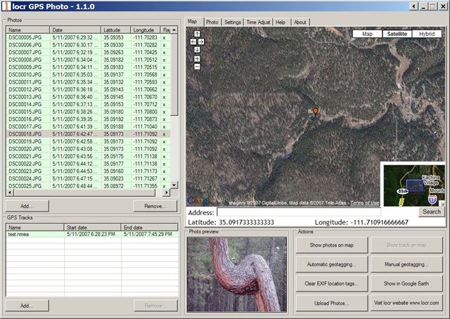
Locr is a web album site oriented around geographic location, where you can upload geotagged photos, share them, and have them display in an album or on a map interface. Basic accounts are free, and while I assume that premium accounts will be available for a price at some point, I can’t seem to find any mention of that on the site. Geotagging can be done with separate software called “locr GPS Photo”; the software is free, and available for download even without registering for the site. Make sure you download the PDF manual as well, as you’ll probably need it. You can either manually geotag a photo using a Google Maps interface, or use GPS data to assign geotags. Here’s the basic interface:
locr free geotagging application.jpg

The software does work, but it’s not without quirks, particularly for automatic geotagging with GPS data.

1. One of the biggest pains of locr is that it doesn’t accept standard GPX files for geotagging – it requires nmea files. You can convert GPX to nmea using GPSBabel, and the following procedure from the help file:

Converting gpx file into nmea format

  • Double-click the “GPSBabelGUI.exe” file to start GPSBabel.
  • In the GPSBabel window select the “Format” of the input file: “GPX XML”.
  • Click the “Start the file open dialog” button and select the respective folder and input file.
  • As “Output Format” select “NMEA 0183 sentences”.
  • Click the “Start the file save dialog” button to determine the output folder. Enter the file name. Do not forget the “.nmea” file extension!
  • In the menu click “Options” and select the “Filter” command (or click the “Filter” button).
  • In the “Filter” window activate the “GPS fixes” check box and select “pps” as option. Click “OK”.
  • Then click the “Let´s go” button.
    The gpx file will be saved in the nmea format, which then can be opened in the GPS Photo software.

Make sure you have the latest version of GPSBabel and the GPSBabelGUI. And be prepared for problems. In particular, if any of your GPX trackpoints don’t have a timestamp, GPSBabel won’t be able to create the nmea file, and will generate an error message. You’ll have to open the GPX file in a text editor, manually delete the trackpoints with no timestamp, then save the file as a new GPX file before using GPSBabel to convert it to the nmea format. Hopefully, locr will recognize the need to accept the standard GPX format in their program, and add it as an option sometime soon.

2. Sometimes, it won’t tag a photo in a series; if that happens, click on the “Clear EXIF location tags”, and that may be enough to get it to work.

3. The geographic location is written in the EXIF tag, but some programs (like Picasa) can’t read EXIF tags modified by locr. 9/3/08: I’ve heard this is no longer an issue. The problem apparently results from a problem that Picasa has reading the GPSVersionTag created by locr. There’s a fix for this: download EXIFTool, a free command-line utility for EXIF tags, re-name the executable file to exiftool.exe, copy it to the directory with the photos in it, and from the command line execute the following command:

exiftool -GPSVersionID=0.0.2.2 -overwrite_original *.jpg

This will re-write the GPSVersionID tag to one that Picasa recognizes, and Picasa will then pick up the geotagging information in those photos.

Addendum: Check this follow-up post for a GUI for EXIFTool.

On the plus side, manual photo geotagging is fairly painless – zoom in to the area in a Google Maps interface, select the photo, and click on the “Manual geotagging” button to tag it. You can also enter an address into a search box, and have that be automatically geocoded for you. You can then move the marker manually after the initial tagging to fine-tune its position. Select a group of photos that have been geotagged, and click on the “Show photos on map” button, and their positions will be indicated on the Google Map. You can also select a set of photos, and create a KML file of thumbnails for display in Google Earth with the push of a button.

If locr would accept GPX files, not have the occasional tagging glitch, and write the GPSVersionID tag properly, it would be pretty awesome. Even with those faults, though, locr is still pretty good, especially at the price.


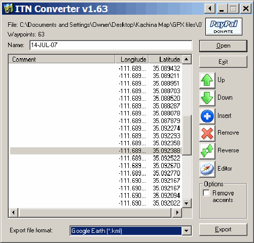
GPS File Format Converter

Ogle Earth posts about ITNConv, a program that converts from one GPS format to another. It opens:

– Autoroute Express (.axe, .axg)
– Streets & Trips (.est)
– MapPoint (.ptm)
– MapSource (.gdb, .mps)
– TomTom 3, 5 & 6, Go, Rider, One (.itn, .ov2)
– Navigon MN|4, MN|5 & MN|6 (.rte)
– Destinator PN (.dat)
– Marco Polo, Falk Navigator, Motorrad Tourenplaner & OnRoute (.bcr)
– GPS eXchange (.gpx)
– GPX MapSource (.gpx)
– Garmin PCX5 (CartoExploreur) (.rte)
– Magellan SD (Meridian et eXplorist) (.rte, .upt)
– ViaMichelin (.xvm)
– IGN Rando (.rdn)
– OziExplorer (.rte)
– OziExplorer CE (.rt2)
– Google Earth (.kml)
– CSV (Longitude,Latitude,Comments)

And writes in:

– Autoroute Express (.axe) (Version 2004 and higher)
– TomTom 3, 5 & 6, Go, Rider, One (.itn)
– Navigon MN|4, MN|5 & MN|6 (.rte)
– Destinator PN (.dat)
– Marco Polo, Falk Navigator, Motorrad Tourenplaner & OnRoute (.bcr)
– GPS eXchange (.gpx)
– GPX MapSource (.gpx)
– Garmin PCX5 (CartoExploreur) (.rte)
– Magellan SD (Meridian et eXplorist) (.rte)
– ViaMichelin (.xvm)
– IGN Rando (.rdn)
– OziExplorer (.rte)
– OziExplorer CE (.rt2)
– XML Location (.loc)
– Google Earth (.kml)
– CSV (Longitude,Latitude,Comments)

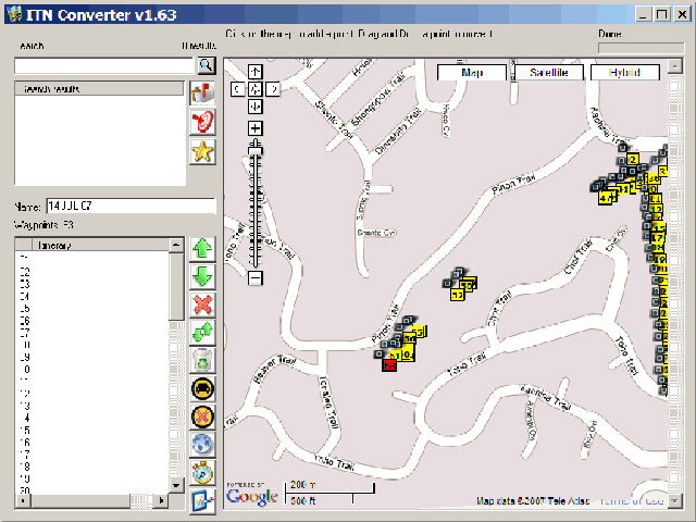
Not as many as GPSBabel, but it does a few that GPSBabel doesn’t, and the interface is a bit easier to handle:

GPS file format converter

It’s very much point-oriented, though. If you convert a GPX file with several tracks into a KML file, it will connect the endpoints of successive tracks to create one single, long track. Similarly, if you convert a set of waypoints into KML, it will connect all the points sequentially into a single long track (but you can always turn the track off in Google Earth, or delete it entirely). GPSBabel handles tracks better.

One nice touch is the built-in editor that loads the points into a Google Maps interface, where you can re-label them, move them around, add or delete points, search, find get directions, etc.. You can even create a set of points, and then save them in one of the supported formats:

GPS file format converter

Note: The website is in French, but the program itself is in English. Look for the download at the left under “Telechargement”, or at the bottom labeled “Télécharger la version Windows“.