blankblank blank


Archive for the 'GPS' Category Page 12 of 25


World OpenStreetMap Data In Shapefile, XML and Garmin Formats

A while back, I posted on GeoFabrik’s repository of Open Street Map (OSM) data in shapefile format, covering mainly Europe and parts of Asia. CloudMade now has this data freely available for download as well, but not just in shapefile format, and not just Europe, but every continent (including Antarctica). Broken down by country/state, you can download:

  • OSM XML extracts
  • Garmin Map Files (OSM.err edition)
  • Osmosis country bounding polygon
  • Shapefile extracts
  • Navit maps
  • GPX POI
  • TomTom POI

The latter two are a bit lacking in data now, to put it mildly, but presumably will grow in size with time. CloudMade is developing APIs to deliver the OSM map data in web and mobile format, but these are currently in alpha and limited to developers.

The Garmin data comes as a gmapsupp.img file, which you can copy directly to the SD/microSD card of a compatible Garmin unit; see this post for more info. The problem with Garmin map data in this format is that you are limited to having only the data embedded within that single file loaded into your GPS; you can’t combine it directly with other Garmin mapsets. And because the gmapsupp.img file can contain multiple sub-tiles, you can’t add it to the MapSource program using MapSet Toolkit; trying to do so will only make a single sub-tile visible. But there’s a way to split that gmapsupp.img file into its constituent sub-tiles, making it installable into MapSource, and I’ll cover that in tomorrow’s post.
Download A Google Maps Search Result To A GPS

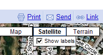
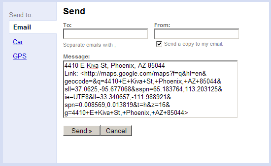
Just found out about this feature recently: if you enter a location into the search box in Google Maps, you can download the result as a waypoint directly to some GPS systems, including Garmin and TomTom. After you get a search result in Google Maps, click on the “Send” link in the upper left:

11-3-2008-9.19.35 PM

You’ll get a box that comes up with the default to email the map link, but there are additional links for Car and GPS:

11-3-2008-9.20.53 PM

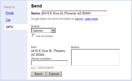
Click on GPS, and choose your brand: Garmin, Pioneer or TomTom:

11-3-2008-9.23.07 PM

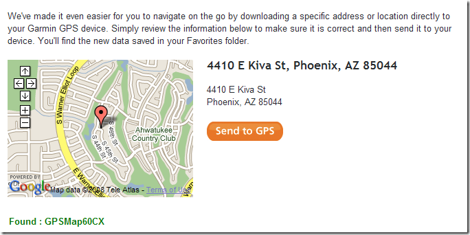
Click on Send, and you’ll be directed to a page that lets you download it to your GPS:

11-3-2008-9.25.32 PM

To use this feature, you’ll need to have the right software installed on your computer to use it with your GPS:

Clicking on the Car option brings up the option to send the waypoint to a BMW or Mercedes-Benz built-in GPS if you have a BMW Assist or Mercedes Tele-Aid account.


Raster Maps And Photos On The Magellan Triton Handheld GPS

Late last year, Magellan introduced their new Triton series of handheld GPS units, whose higher-end models let you download raster topographic maps to the unit from the commercially-available National Geographic Topo! series. Initial reaction to these units was very bad; you can see how bad by reading the Amazon.com reviews for these units:

Magellan Triton 400 Handheld Navigation System

Magellan Triton 500 Handheld Navigation System

Magellan Triton 1500 Handheld Navigation System

Magellan Triton 2000 Handheld Navigation System

Supposedly many of the initial problems with these units have now been fixed. And now there’s a free program on the GPS Tools website by Mikhail Sharonov called TritonRMP that lets you calibrate and convert any raster image, map or photo, to a Triton-compatible format. I don’t own a Triton, so I can’t try it out, but users on the Triton forum are reporting good results with many different kinds of raster images. And at less than $175 for the Model 400 Triton, this may be the cheapest way to get decent raster imagery on a handheld GPS.

If you own a Magellan GPS of any type, the entire GPS Tools website is worth a look. While there are lots of tools for map and data creation for Garmin handheld GPS units, there is far less support for Magellan units, and Mikhail’s website has more tools for the Magellan than I’ve seen anywhere else.

Via GPS Tracklog.


Prune Updated To 6.0 – Photo Geotagging And GPS Track Visualization For Windows, Mac And Linux

The Java-based GPS and geotagging application Prune, covered in earlier posts, has been updated to version 6.0. New features include:

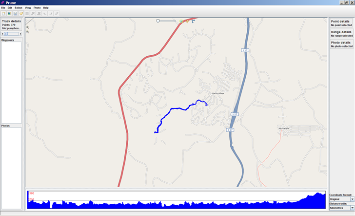
  • Map view using OpenStreetMap images is now integrated in the main window, with control for map transparency; you can open up an OSM map or Google Map for the track location in a browser as well

Prune Java-based geotagging application
(You may have to turn off the firewall in Windows to get this to work)

  • Pov export has a new option to use sphere sweeps for better appearance
  • New function to check online for a newer version of Prune
  • New function to take a section of track and cut/paste it to another position
  • New function to add or subtract a time offset from point timestamps to correct for time shifts between a GPS track and camera time
  • New function to call gpsbabel to load data directly from GPS receiver
  • Additional file filter options on load and save
  • Italian language support

Full support for all its features requires downloading of the Java3D library, exiftool, and GPSBabel.


Updates On The Garmin 1:24K US Topographic Map Front

Garmin continues to slowly add more and more states to their vector-based 1:24K US topographic map coverage. The latest release covers the central mountain West, Colorado and Utah, joining sets for Washington and Oregon as well as California and Nevada . These are in addition to their previous sets for US National Parks in the East, Central and West US; their websites says that maps for the rest of the US are “Coming Soon”. These Garmin 1:24K topo mapsets have some useful features, like elevation profiles, points of interest, routing on trails and dirt roads, and overlays for USGS topo quad and Township-Range-Section information. But at $100 list price ($80 street) for each set, it’s going to get pretty expensive to own even a small number of these. And since they’re being issued on microSD cards, they can only be used on one Garmin GPS unit at a time.

Fortunately, Dan Blomberg at the GPS File Depot, the MiscJunk website, and others continue to release their own versions of 1:24K topographic maps. While they don’t have all the fancy features of the Garmin sets, they’re free, based on the same US Government data as the Garmin maps, and can be uploaded to as many Garmin units as you like. Since my last update, Dan has released new 1:24K topo mapsets for New Mexico and Hawaii, and Idaho is coming soon; there’s also a new transparent overlay for Wyoming land usage/ownership. From the forum on his website, others following the process laid out in his tutorial on making Garmin topo maps are working on similar mapsets for Washington, Missouri and Florida as well. Dan has a list of links to all currently available free 1:24K Garmin topo mapsets at this link; currently, mapset links are listed for AZ, NM, CA, UT, CO, WY, MT, HI, MA, and MS. Maine is also available, but a link to that mapset is missing for now on Dan’s list.

And if you want actual USGS topo maps on your Garmin GPS unit, as well as other raster imagery, there are options …


Uploading .img Map Files to A Garmin GPS Unit With IMG2GPS

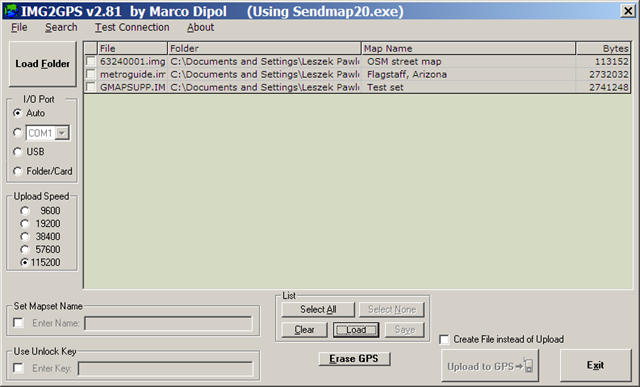
An earlier post covered MapUpload, a free program for uploading .img files to a Garmin GPS; another option for this operation is IMG2GPS. This is actually a limited front-end to the command-line program SendMap (included in the IMG2GPS install package), but it supports most of SendMap’s upload features you would normally use.

img2gps

You don’t select .img files for loading into the selection list individually; instead, you specify a folder using the “Load Folder” button, and all .img files in that folder are automatically added to the list. Selecting another folder will add those .img files, while not erasing the ones already there. To erase all the files in the list, click the “Clear” button at the bottom; this clears all the files in the list, regardless of whether they’re selected using the check box. You can save a list of selected files with the “Save” button, and load that list with the “Load” button; it also supports the .gdb format created by MapSource. Finally, you can search through the list of files for a text string in either the filename or the map name using the “Search” function at the top.

To upload one or map files to your GPS, select them with the check box, make sure your GPS unit is turned on, and click “Upload to GPS”. In “Auto” mode, the program should automatically detect a connected GPS, running through all the options (USB and all COM ports). If the program has difficulty recognizing that you have a GPS connected, you can use the “Test Connection” function at the top to help diagnose the problem; you can also manually specify the I/O port your GPS is hooked up to. You can also set a mapset name label for all the maps being uploaded by checking the box below, and entering the desired label.

Unlike MapUpload, IMG2GPS supports uploading to a data card (like a microSD card) in a card reader, which can be faster if the card reader is USB 2.0 (most Garmin GPS units are USB 1.1). Oddly, it doesn’t seem that you can do it directly using the “Folder/Card” option for I/O Port. Instead, you have to combine all of the selected maps into a single “gmapsupp.img” file, and then upload that file to the “Garmin” folder on the data card (see this post for more info on the “gmapsupp.img” file). To do this, check the box at the bottom marked “Create File instead of Upload”; this will change the button below to “Create File”. Press the button, and then select the “Garmin” folder on the data card to save the “gmapsupp.img” file in (create the folder if it’s not already there). When you put the card back into the GPS, the “gmapsupp.img” file will be recognized and read as a map file.

There’s another front-end for Sendmap called GPS Send Map, but it’s obsolete, doesn’t appear to be in development anymore, and doesn’t have the features that IMG2GPS  has.


New App For Real-Time GPS Tracking In Google Earth

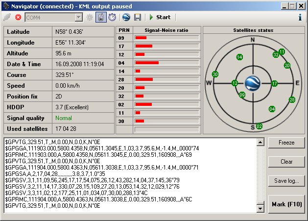
In my series on getting Google Earth Plus features for free, I reviewed a number of apps that interface a GPS unit with Google Earth, plotting your current position and/or recording your track. There’s a new one out from Valery Hronusov and friends called Navigator that appears to be better than all those, but since I’m away from home, I can’t try it out yet. The feature set looks impressive:

  • Supports USB and serial connections, including Bluetooth
  • Supports simultaneous connections with multiple GPS units
  • An information screen with many useful outputs, including position, course and speed, HDOP (horizontal dilution of precision, a metric for how accurate the GPS fix is based on satellite geometry) and more

  • Additional windows for position info, marking a waypoint, tracking, and more.

I’ll have a full hands-on review later on, but if you’re interested in this kind of app, it’s worth a look right away.


Garmin Map Roundup