

Many programs these days come with the built-in capability to produce output in the PDF format. For those that don’t, there’s a free program called PDFCreator that adds a printer driver to Windows; print to PDFCreator, and instead of hard copy output, your print results go into a standard PDF file, readable by Acrobat Reader or any other PDF-capable program. But what makes this a “GeoTool”?
Author Archive for Leszek Pawlowicz Page 75 of 79
The U.S. Census Bureau produces TIGER/Line vector data files (Topologically Integrated Geographic Encoding and Referencing). From the Census Bureau’s TIGER overview:
“The TIGER/Line files are a digital database of geographic features, such as roads, railroads, rivers, lakes, legal boundaries, census statistical boundaries, etc. covering the entire United States. The data base contains information about these features such as their location in latitude and longitude, the name, the type of feature, address ranges for most streets, the geographic relationship to other features, and other related information.”
These TIGER files are updated yearly, and contain some of the most current digital data for US streets and addresses. Most GIS programs can’t open TIGER vector files, and ESRI only has free TIGER data in shapefile format for the year 2000. Now a TIGER-to-shapefile converter that used to be a paid commercial program has been released as open source software, free for any use, along with a number of other useful TIGER and Census demographic data utilities.
Continue reading ‘Converting US Census TIGER Data Into Shapefiles For Free’
The Mapperz blog has a new post on ArcGIS 9.2’s Simplify Polygon feature:
“Simplifies a polygon by removing small fluctuations or extraneous bends from its boundary while preserving its essential shape.”
A nice tool to have to simplify polygon shapefiles with too high a level of detail. But suppose you don’t have ArcGIS 9.2 (at around $1500 list)? There’s a free web-based shapefile utility that does something similar.
Shapefiles can be created in any coordinate system, and are often (and annoyingly) found in a coordinate system different than the one you’d like them to be in. For example, several of the shapefile to KML converters posted about recently require that the shapefile be in Google Earth’s native coordinate system: geographic coordinates (latitude/longitude), WGS84 datum; what do you do if your shapefile is in a different coordinate system, like UTM, Lambert Conformal Conic, or State Plane Coordinate System? There are lots of free conversion utilities out there that can reproject shapefiles from one coordinate system/datum to another, but there’s one I prefer because it’s fast and easy to use.
Continue reading ‘A Free And Easy Shapefile Coordinate Converter’
The three previous posts in this series have examined completely free options for exporting shapefile data into Google Earth’s KML format. Each of those had advantages and disadvantages, with the biggest advantage for all being that they’re completely free.Today I’ll take a look at an option that isn’t free, but which at $29.99 I would classify as “cheap”, especially given its capabilities. And the free demo version lets you import up to 1000 features, enough to evaluate whether it meets your needs.
Continue reading ‘Exporting Shapefiles To Google Earth IV – Shape2Earth’
Note: shp2kml seems to be currently unavailable; try AFFMapper as an alternative.
Two earlier posts talked about free, quick and simple ways to export shapefile data to Google Earth’s KML format. Both had limitations on how much of the shapefile’s attribute data could be imported into the KML file, and how the shapefile data could be displayed, especially polygon shapefiles. There are two programs I know of that allow you to export shapefile data to KML format with multiple attributes, and also modify the colors with which the shapefile data is plotted based on attribute data. One program is completely free, but has quirks and limitations; the other is not free but cheap, and is more flexible and capable. Today’s post looks at the free one.
Continue reading ‘Exporting Shapefiles To Google Earth III – shp2kml’
In the first post of this series, GPS TrackMaker was used as a simple way to export point and line shapefile data to Google Earth’s KML format. But GPS TrackMaker is limited in its ability to export shapefile attribute data; it can only export one attribute to label each shape plotted. And it has difficulty dealing with shapefiles that have large numbers of vertices. Today’s post will deal with a simple free program that allows you to export data from multiple attributes to the KML file, and which also seems to have fewer problems with large shapefiles.
Continue reading ‘Export Shapefiles To Google Earth II – Shp2KML Converter’
If you need to plot a coordinate position quickly on a wide variety of maps from different websites, or if you want to find a list of nearby geocaches, benchmarks, or other info, here’s a neat little website for that:
The GPS Coordinate Converter, Maps and Info website lets you enter a set of geographic coordinates (latitude/longitude, WGS84), converts them to decimal/degree-minute-second equivalents and UTM coordinates, and plots the position in a small Google Maps window on the right:
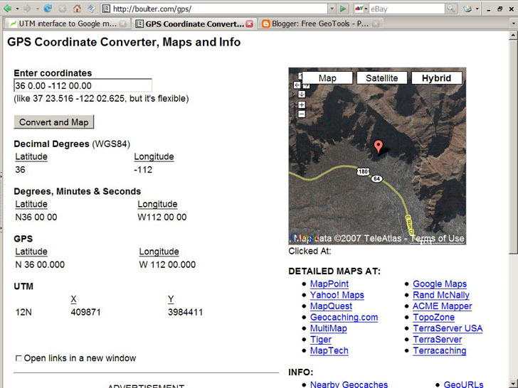
The “Enter coordinates” box at the top is fairly flexible, so you can enter coordinates in both decimal and degree-minute-second format.
Although you can select the standard Google Maps display options on the right, Map, Satellite or Hybrid, you can also open up a map for this position from a wide variety of mapping websites, listed below the small map image under the “Detailed Maps At:” heading. Open it on the official Google Maps site, Yahoo Maps, MapQuest, TerraServer, and a whole bunch more.
Below the Detailed Maps links are separate links to geocaching sites, benchmark sites and more; click on these links, and the matching website opens with the coordinate data you’ve entered above automatically passed to the website (in most cases).