The Mapperz blog has a new post on ArcGIS 9.2’s Simplify Polygon feature:
“Simplifies a polygon by removing small fluctuations or extraneous bends from its boundary while preserving its essential shape.”
A nice tool to have to simplify polygon shapefiles with too high a level of detail. But suppose you don’t have ArcGIS 9.2 (at around $1500 list)? There’s a free web-based shapefile utility that does something similar.
MapShaper is a Flash-based utility that will take your line or polygon shapefile (16MB maximum), and let you:
- “edit linework interactively”
- “simplify and smooth excess detail”
- “export edited layers in multiple formats”
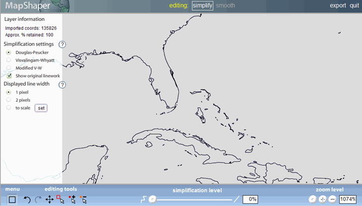
Here’s a screenshot showing a subsection of the sample world data set that you can load to try out the program, part of the Gulf of Mexico/Caribbean Sea area:

The controls on the bottom allow you to zoom in and out, add, subtract, and “lock” shapefile vertices so they won’t disappear during simplification (to give you some control over which features won’t get “simplified out”), and set the simplification level using the slide control. Controls on the left let you select the simplification algorithm, leave the original shapefile lines up for comparison purposes, and set the line drawing display mode. Here’s the same map as above, but with the simplification set at 50%:

As a bonus, the number of vertex coordinates is reduced to 13% of the original, making it smaller and faster-loading. Once you’re done, you can export the simplified data as a shapefile, or as an Encapsulated PostScript (EPS) file for printing. Because it’s done in Flash, MapShaper should run on any OS with a browser that supports Flash.
You have a wonderful blog and do a great job of postinig lots of very useful information. Please keep it coming!
Worse – it’s not available in ArcView. Once you shell out $25,000 or so for ArcINFO, then you can use the feature. Thanks!
This site is dead. You cant save your simplifyed data
Hello
When we simplify our polygons using this method , polygons and small islands disapear. Can we put a limit on that and not allow number of points in each polygons go below a certain number? so we can stop disappearing of polygons.
You can adjust the simplification level so as not to lose too much detail.
This was a wonderful tool that did exactly what I needed. IT got rid of several holes that showed up in my polygons after a Merge. Thank you!