blankblank blank


Prune – Java-Based GPS Track Visualization And Photo GeoTagging


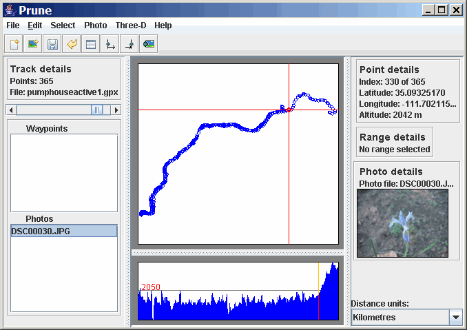
Prune is another Java-based GPS tool with its own unique set of features, including:

- Load multiple text, GPX or KML tracks, appending them to each other

- Trim duplicate points, and compress the track (hence the name Prune)

- Save combined tracks in text or KML format (use GPS TrackMaker to convert the KML tracks to GPX format if desired)

- See a plot of position, and altitude if available

- Manually geotag photos by connecting a track point and a photo, and writing the data to the photo’s EXIF header (requires that EXIFtool be located in the same directory as Prune). This is OK for one or two photos where you know the exact location, or for tracks with no timestamp, but otherwise you’re better off using GPicSync or another GPS photo geotagger. The author of Prune is thinking of adding automatic photo geotagging with GPS track data in version 4, which would make this program a useful option for Macintosh or Linux users who don’t have as many free geotagging options as Windows users.

prune

- 3d views of tracks (requires the Java3D runtime). Click and drag in the window to rotate the track view.
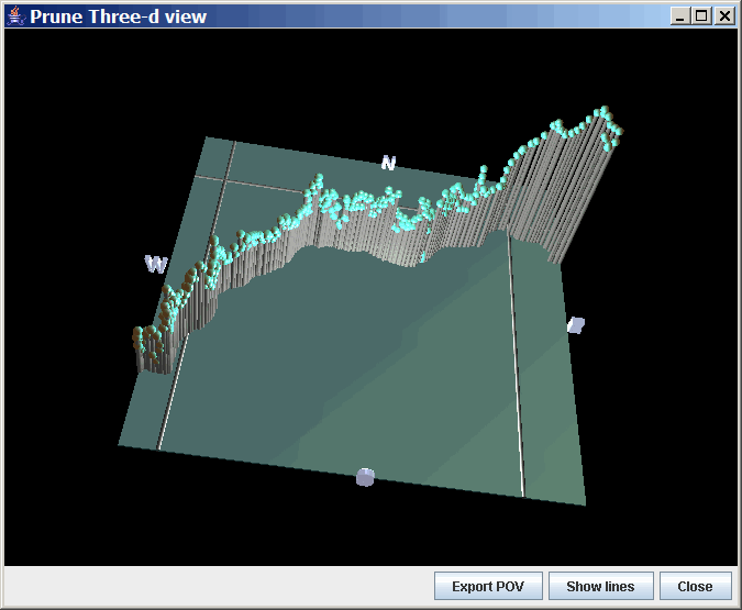
prune3d

- Export in POV format for the raytracing program POV-Ray; the screenshots of that program’s output look similar to the Java3D screenshot above.

USGS Topo Maps, Aerial Imagery, And Scanned Maps On Your Garmin GPS!

Choose The Right Option For Your Garmin Handheld Model


sf sf

Actual screenshots from a Garmin Oregon!

G-Raster For The Garmin Colorado/Oregon/Dakota/62/78 Series


“… great (tool) for creating custom maps ...”
GPS Tracklog Blog

“… easy as 1, 2, 3.”
gpsinformation.net

“Works great!”
GPSFix

"Holy crap; this looks amazing.”
GPSFileDepot

Click here for more info on G-Raster


sf sf

Actual screenshots from a Garmin 60Cx!

Moagu For The 60C(S)x, 76C(S)x, And Some eTrex Models


"... Moagu rocks! This really is revolutionary!"
GPS Tracklog Blog

Click here for more info on Moagu


Related posts:

  1. Prune Updated: Now With Automated Photo Geotagging For Windows, Mac, And Linux
  2. Prune Updated To 6.0 – Photo Geotagging And GPS Track Visualization For Windows, Mac And Linux
  3. Two Photo Geotagging Briefs
  4. Prune GPS/Geotagging Tool At Version 10
  5. Photo GeoTagging III – WMMX Location Stamper
  6. Updates To Photo GeoTagging Software
  7. Automating Your Garmin Oregon Photo Geotagging Flow Using GeoHarvest
  8. Geotagging Photos With GPSed
  9. GeoSetter: The Best Free Photo Geotagging App?
  10. Microsoft's New Photo Geotagging Tool
  11. The Simplest Windows Photo GeoTagging Tool
  12. Photo GeoTagging II – Locr
  13. Photo GeoTagging IV – GPicSync
  14. GPS Photo GeoTagging I – Two Simple Solutions
  15. Using GPS Data To Geotag Photos: The Basics

Looking for something else? Enter some keywords below, then click "Search".