blankblank blank


Archive Page 14 of 106


Easy Conversion Of GPX Files To Garmin Format With GPX2IMG

Joel emails to announce that his GPX2IMG program is finally ready for official release. GPX2IMG imports standard GPX data files (tracks and waypoints), lets you edit them, converts them to IMG Garmin-compatible format, and even installs the map file into MapSource or BaseCamp for easy upload to your Garmin GPS unit. The program isn’t fully free; regular price is $20 (available for $13 until 9/23/10). However, the demo version will let you import up to two GPX files, edit them, convert them to .img format with a watermark, and even install them in MapSource; the registered version removes the file limit and watermark.

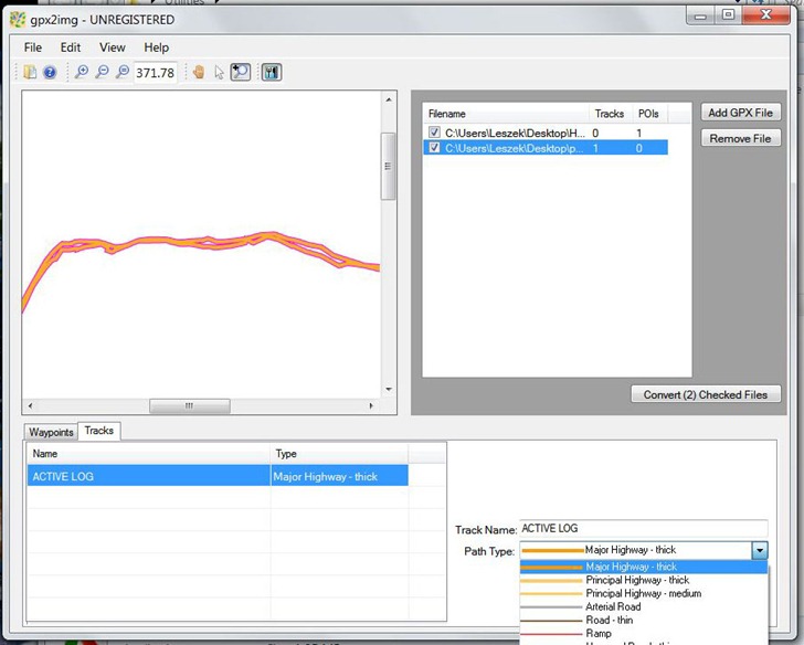
Interface is clean and simple; load in your files and view the data in a map window. GPX2IMG lets you select waypoints and tracks, edit their names and other info, and set their appearance to standard Garmin point/line types:

gpx2imgscreenshot

You can’t modify the actual track point data itself, nor can you move a waypoint/POI. You can create a waypoint by double-clicking the map area, but the inability to set the specific latitude/longitude of  that waypoint is a drawback. You can use custom TYP files to create your own linestyles; instructions are in the comprehensive help file (and there are videos on the GPX2IMG website).

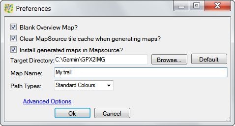
Once you’re done with adding/editing data, set the desired parameters in the Preferences window:

preferences

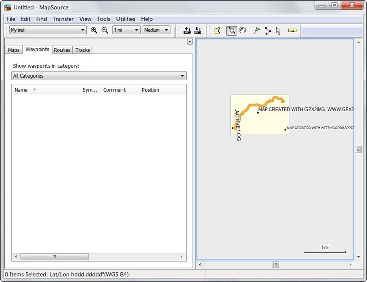
Then click on the “Convert Checked Files” button to start the process. In the unregistered version, you’ll have to wait 15 seconds. GPX2IMG will compile the GPX data into a .img file, and then install it for use in MapSource or BaseCamp for uploading to your Garmin:

MapSource

A few minor issues:

  • A waypoint file of mine didn’t import successfully; I’ve passed it on to the author, and I assume that issue will get fixed shortly.
  • You can only have one GPX dataset created by GPX2IMG loaded into MapSource/BaseCamp at a time; I would hope this will change, as that really is a major drawback.
  • You can’t uninstall the mapset from within the GPX2IMG program; you can use a separate program like MapSet Toolkit to do this, but I’d like to see that option directly within GPX2IMG.

You can create your own Garmin map from GPX files using fully-free tools; see my many-part series on Tools For Custom Garmin Vector Maps. Doing it yourself is more complicated, takes longer, and there’s a steep learning curve, but you’ll have more flexibility in the final results. But if you want to bypass those complexities, and just quickly generate simple Garmin map files from your own data, GPX2IMG works and is easy to use. Even the limited demo version has enough utility to make it worthwhile.

Note: See comments section for Joel’s info on updates/fixes.


OpenDragon: New Open-Source Imagery Analysis Program

The Global Software Institute announces that their Open Dragon software, a variant of Goldin-Rudahl’s Dragon/ips software for aerial/satellite imagery analysis, is now freely available for non-commercial use, and the Java source code will be released as open source sometime in the near future. From their press release:

OpenDragon offers a full suite of image analysis and raster GIS capabilities including image enhancement, supervised and unsupervised classification, geometric correction, measurement and statistics, vector capture and display, slope, aspect and buffer calculations and multi-criterion decision making. Open Dragon also includes the Open Dragon Toolkit, which allows users who can program in C to extend the software functionality. GSI will also make the source code for OpenDragon available for non-commercial use under an Open Source license during the next six to nine months.

Installation is currently kind of a pain – you have to register for a key code just to download the software, and then unzip all files to a directory. The setup program in the main directory doesn’t create the program directory but requires you to select one, so you should create that (and a Temp directory) before starting program installation. Registration requires an internet server connection that the program seems to have trouble establishing; this process will supposedly be simplified in the near future. And, at least under Windows 7, running the program downgrades the color scheme to Windows 7 Basic for some unknown reason; first time I’ve seen this with a Java program. No uninstall listing added, either, though with Java software just deleting the program directory and icons is usually good enough.

A full PDF manual is included with the installation package.

Added to The Big List Of Satellite/Aerial Imagery Analysis Software.


Multiple Coordinate Systems In Google Maps, Reverse Geocoding, And More With The Worldwide Coordinate Converter

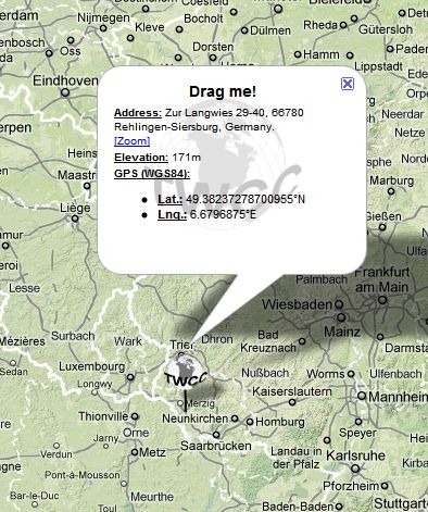
Clement Ronzon emails about his new website, The Worldwide Coordinate Converter (TWCC for short). Drag the globe-shaped icon to the desired location in a Google Maps interface, and get a pop-up balloon with the geographic coordinates for that spot, elevation in meters, and the nearest reverse-geocoded address:

twccballoon

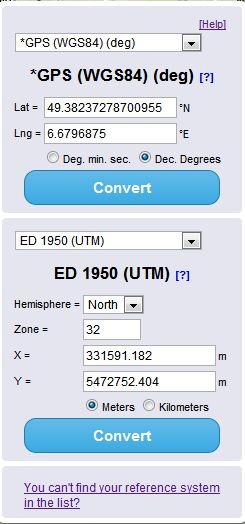
At right is a two-part coordinates box, with latitude/longitude/WGS84 always in the top part, and a user-selectable coordinate system at the bottom:

coordschooser

You can also enter coordinates into the appropriate boxes in either the top or bottom section, click Convert, and have them converted to the other coordinate system automatically (and plotted on the map).


Geographic Polling Website SurveyMapper Now Live For The United States

The Centre for Advanced Spatial Analysis, University College London’s SurveyMapper site has been live for the United Kingdom for a while now, but just added the ability to do geographic-based survey polls for the United States as well as Europe and the entire world. The process for creating a survey couldn’t be easier. After free registration, click the “Create Survey” button; the first page will ask for basic info:

Continue reading ‘Geographic Polling Website SurveyMapper Now Live For The United States’


New Android-Related Website: AndroGeoid

After my previous two posts on Android, you might expect to see posts on Android-related topics showing up here at Free Geography Tools. That was my original plan, but I’ve decided that Android is a distinct-enough topic to warrant its own website. So, I’m announcing my new Android-specific website, going online today (8/18/10): AndroGeoid. There, I’ll cover apps and topics related to using Android hardware and software to explore, measure, record and map the world. This will include obvious geography-related topics, like apps for :

  • GPS
  • GIS
  • Map displays
  • Compasses
  • And so on …

But the website’s focus will range well beyond that, to topics that encompass some of Android’s more unique capabilities;

  • Geographically-related Augmented Reality
  • Location-linked online information resources
  • Crowd-sourced data collection
  • Measurement apps that take advantage of Android’s sensor suite (accelerometers, orientation, magnetic field)
  • Applications for recording full sets of information linked to location: Coordinates, direction, orientation, notes, photos, videos, sound, panoramas, augmented/virtual reality, and more.
  • And other cool stuff …

The Android world is currently dominated by smartphones, connected wirelessly via 3G to the Internet, and I’ll cover apps that take advantage of that. But the ecosystem is likely to expand very soon to models that only come with WiFi connections, and even with smartphones there will be times when no connectivity is available. So, I’ll also cover apps that work with non-connected stand-alone Android devices.

And the name, AndroGeoid? Well, GeoAndroid  was already taken ;-). But AndroGeoid works for me: the geoid is:

that equipotential surface which would coincide exactly with the mean ocean surface of the Earth, if the oceans were in equilibrium, at rest, and extended through the continents …

So sayeth the almighty Wikipedia. In other words, all things geo-related to Android will flow downhill to the AndroGeoid.

The first couple of posts may look familiar – they’ll be slightly revised versions of the posts I’ve done this week on Android. New material should start showing up on Friday. Plus, I’ll have a brief weekly listing/recap of AndroGeoid posts on this site, usually on Fridays.

And in case you were wondering, I still expect to post regularly on the Free Geography Tools site at about the same frequency as I have been, about 4 posts a week. Hopefully, I can keep both sites up and running at the same time. Not unrelated, I’ve got a new Guest Post page up ;-).


Android: The Future Of Consumer GPS – Part II

After yesterday’s magnum opus about how Android will transform the consumer GPS industry, today’s shorter post is a few random thoughts on how the big three handheld GPS makers might be affected by Android, and how they might respond. Personally, I think it’s going to be tough for them to adapt. Up until recently, handheld GPS units have been a fairly limited specialty market, allowing manufacturers to control interfaces and map data, and charge exorbitant prices due to limited competition. In most consumer electronics fields, prices drop even as capabilities increase; that really hasn’t been the case for handheld GPS. Android has the capability to turn GPS into a commodity market, meaning less control and more competition, leading to lower prices. And this is an environment that the old-school GPS vendors may have trouble with.

Magellan: Magellan is still struggling to overcome the disastrous premiere of their Triton line in 2008: decent hardware with capabilities unique at the time (raster imagery, 3-axis compass) sabotaged by horribly buggy software. Most of these problems got fixed, but too late to make a difference. Magellan was acquired late in 2008 by MiTAC (parent company of Mio, and they’ve just recently announced a new series of Explorist models, due out this fall.  For standard GPS models, the specs on these look pretty good, and the prices are very competitive. But in the long run, I don’t see how they can compete with more-capable Android models that are likely to sell in the same price range or even lower.  Putting someone else’s Android unit into a Magellan body with a better antenna and waterproof/field-rugged design might be a better way to go. They already have some experience using that approach with their new case for the iPhone, which enhances the iPhone’s GPS abilities while offering better protection against the elements; they just have to do it more cheaply.

DeLorme: DeLorme has moved into second place for handheld GPS units with their PN series, the first consumer models with raster/aerial imagery, and the first models with an affordable subscription plan for this imagery. They’ve also come out with a new model recently, the PN-60, with an upgraded interface and the ability to interface with SPOT communicators for satellite text messaging. But $400 for a GPS with a 2.2” display? No touchscreen? No apps? Their $250 xMap software lets you upload GIS data (raster and vector) to their PN models, but you can already put raster imagery on Android models, and GIS vector data can’t be too far behind. I don’t see this proprietary hardware line as having much of a future, and they don’t have much experience with alternative hardware.

Garmin: Garmin seems to develop an OS for their GPS units, and then use it as long as they can. The OS developed for their eMap model in 1999 was adapted and upgraded for most of their handheld models through 2006, culminating in the classic 60/76Cx series. These were probably the best-selling handheld consumer GPS series of all time, and four years later are still among their most popular units. They’re only 2.5 years into their next-gen GPS OS, the one that powers the Colorado/Oregon/Dakota/62/78 series, and they’ve certainly released a ton of variant models in these lines. The question is whether they can move past their own proprietary hardware and software designs and move quickly to an Android platform, using their strong GPS expertise to bring additional features that will differentiate their models from the rest of the market.

I’d like to think so – I’ve been a Garmin fanboy for 10 years now, and even now that I own a Droid X, you’ll have to pry my 60Cx out of my cold dead hands. But their recent history isn’t encouraging. Their first attempt to move Garmin technology to a cellphone platform, the nuvifone, was universally despised by reviewers. Their second effort, the Garminfone, was based on the Android platform, and received much more favorable reviews; the car navigation software of the Garminfone is generally considered to be the best Android car navigation system so far. If the phone had come out in the latter half of 2009 as originally scheduled, it could have been a huge success. But instead, it was first released in June 2010, and was crippled by:

  • Older software; it ran Android 1.6 when every other phone being released at the same time ran Android 2.1
  • A custom interface that makes it very difficult to upgrade to more recent Android versions
  • Slow processor
  • 3 MP camera
  • A screen pixel count 1/4 of its similarly-priced competitors, and a smaller screen
  • Garmin car navigation software on competing models that, while not as good, was free
  • Lousy battery life
  • No headphone jack

In short, simply not competitive with other Android phones. A month-and-a-half after being introduced for $199.99, it was already discounted by $70, and was part of a “buy one, get one free” package from T-Mobile. Even with that, it’s only sold about 20,000 units, which Garmin themselves acknowledged as a disappoint performance in their latest quarterly report..

If Garmin is going to survive in the consumer market, they’re going to have to move faster than that in developing products. And they’re going to have to give up control of the overall interface in favor of Android’s standard, putting their interface into just their applications. And they need to leverage their GPS engineering capabilities and map data into advantages that make  their units stand out. If they don’t, they’re going to have a tough time surviving in this new market.


Android: The Future Of Consumer GPS – Part I

I’ve owned a handheld GPS ever since the first “consumer-grade” model, the Motorola Traxar, was released in 1993: $900, 6 AA batteries, 8 satellites max, could only record waypoints, and about the size and weight of a brick. Man, was that an awesome GPS unit! I’ve upgraded several times since then, and am glad that handhelds have improved as much as they have. But I’ve always chafed at their restricted ability to record information out in the field: waypoints with a name and short description, tracks with a name, and that’s pretty much it.

Back in January, I posted my “wishlist” for a field-ready GPS unit;  I had hoped that the newer Garmin Oregon models might satisfy most of those requirements, but a lousy touch interface makes those units too difficult to work with. I tried to put together a “field-ready” semi-rugged Windows netbook that met most of my needs, but the poor screen visibility in sunlight conditions was just too great a restriction on its use; while still handy to have, full utility required either shade or a cloth draped over my head. I had pretty much given up on finding what I wanted, and was about to buy one of the new Garmin 62-series GPS units as an upgrade from my trusty Garmin 60Cx; nowhere near all the features I wanted, but enough extra ones (aerial/raster imagery, three-axis compass) to justify the purchase.

A recent upgrade in local cellular antennas finally let me dump my landline phone, and move over to a full-time cellular connection. As part of that process, I decided to pick up an Android smartphone, specifically a Motorola Droid X. While I knew it came with a GPS, that wasn’t the primary reason for getting it – I just wanted a phone that would allow me to stay connected to email and Internet when I was out and about. But having used it for a few weeks now, I’m now convinced that GPS-capable Android-powered units, phones or otherwise, are going to completely transform both the handheld and automotive GPS markets.

Here’s a comparison of my Droid X with the comparable top-of-the-line Garmin unit, the Oregon 550. Bold text indicates which unit IMHO has the advantage in that category.

Motorola Droid X Garmin Oregon 550 Comments
Price $569 list $499 list The Garmin is often discounted by about $100; the Droid X currently isn’t, but will likely drop dramatically in price over the next six months. This doesn’t include cellular plan costs.
Weight 6 oz. 6.8 oz.
Processor Speed 1 GHz 200 MHz (?)
Storage RAM 8 GB 2 GB
microSD expansion Comes with 16 GB, can take up to 32 GB Comes with none, can take up to 4 GB
Display size 4.3” diagonal 3” diagonal
Screen Resolution 480 x 840 240 x 400
DPI 240 157
Color Depth 16 (24) 16 Droid X screen is 24-bit-color capable, but some specs indicate that the OS is only displaying 16-bit color
Daylight Screen Visibility Good Very good Biggest problem with Droid X screen is glare; screen protector helps with that.
Shade/Indoor Screen Visibility Outstanding Very good
GPS Satellites 12 12+ Unclear from specs
WAAS/EGNOS No? Yes Unclear from specs
Assisted GPS Yes No Network signal reduces TTFF
Three-axis compass Yes Yes
Camera 8 MP 5 MP
Multiple camera modes Yes No Droid X has standard, macro, panorama, plus multiple exposure controls
Video Yes – 720p HD No
Barometric Altimeter No Yes
Calculator Yes Yes Droid X has advantage because you can download and install multiple calculator apps
Touchscreen Yes; multi-touch capacitive Yes; resistive A draw; multi-touch is useful, but resistive can be used with gloves on
Keyboard data entry Yes; multiple QWERTY keyboards available, some with text prediction Yes; A-Z keyboard You can choose your preferred data entry mode with the Droid.
Voice-to-text data entry Yes, with wireless connection No
Voice recording Yes No
Text data limits Limited only by unit’s memory Limited by waypoint data fields – about 80 characters
Wireless connectivity WiFi; 3G; Bluetooth Proprietary wireless interface With a Garmin, you can only transfer wireless data between compatible units
Battery life 5-6 hours (?) 16 hours For Droid X, depends on screen brightness, whether you have the wireless connections on, etc..
Field-rugged No Yes Garmin is IPX7-waterproof
Built-in maps Yes Yes Garmin has baseline vector map; Droid has Google Maps
Free up-to-date online maps and POI data Yes No Garmin’s detailed vector maps have to be purchased; updates cost extra. Droid has access to continuously-updated maps for free, but these typically require the unit to be online.
Offline raster maps Yes with third-party apps Yes with Garmin Custom Maps, BirdsEye subscription
Offline vector data Yes with third-party apps Yes with free/paid Garmin maps Garmin data ecosystem still far superior here.
Car navigation Yes (free, but requires wireless connection) Yes (requires paid Garmin maps) Draw; Droid has voice, 3D navigation, but requires wireless connection; Garmin works offline.
Waypoints, tracks, routes Yes with third-party apps Yes Droid third-party apps give you more freedom with what you do with the data
Geocaching Yes with third-party apps Yes
Ability to add additional applications YES NO

I could go on, but just from the above, the Droid X is at least competitive with the Garmin feature-wise, and you could easily make the argument that overall it’s far superior. The few categories where the Droid X falls short (WAAS, ruggedness, battery life) can be partially remedied with add-ons: you can use it with a WAAS-capable Bluetooth GPS transmitter, spare batteries are cheap on eBay, and cases offer some level of physical protection. But more to the point, they are due to the Droid X being designed to be primarily a cellphone, not a GPS unit. It really shouldn’t be hard at all to design a unit that remedies those failings, and sell it at a  reasonable cost.

Here’s a link to a mil-spec ruggedized Android GPS unit already available; currently costs $1200, but divide that by the factor of 3-5 that military contractors typically add on and you’d have a reasonably-priced consumer unit. Less-expensive consumer Android models with GPS are on the way, like the Samsung Yepp at about $350, or this Archos mini-tablet for $150; it’s not that big a stretch to think that fully field-qualified versions of those units could be made and sold fairly cheaply. And I’m especially intrigued by the Notion Ink Adam, an Android-based tablet due out late this year or early next year. The Adam will be offered with an optional 10.1” Pixel Qi LCD screen, which can be switched from a standard transmissive LCD mode to a sunlight-visible transflective color mode, and then to a low-power black-and-white e-Ink-like mode. With  GPS, WiFi, 3G, and built-in camera, this model will sell for $498, or less than a Wifi-only iPad.

But hardware is only a small part of Android’s advantage; the big advantage is that you can put applications onto an Android unit to add functionality, something you can’t do with standard Garmin GPS units. There are already hundreds of position/geography/location-aware apps available for Android units, and that number grows every day. There’s currently only a very limited number of GIS-related apps, but I’d be surprised if many more of those don’t show up soon. And even with the limited number of apps currently available, you can already do far more with an GPS-equipped Android unit than with a standard handheld GPS. Given the impending death of the classic Windows Mobile platform, the primarily OS for many portable GIS and data acquisition apps like ArcPad and Terrasync, it would make sense for companies like Trimble and Ashtech to look at Android as a viable platform for future hardware and software development.

I suppose that the Apple iPhone/iTouch/iPad/iOs ecosystem could be a viable alternative to Android-based models – the hardware and software are certainly good enough – but I doubt it will be. Anyone can license the Android OS and create a hardware device that uses it, which means more models, more competition, and lower prices. Apple has firm and exclusive control of all hardware that runs iOS, which means fewer models and higher prices. I think they’re repeating the same mistakes that resulted in Windows dominating the PC market, but whatever; at least for now, it’s a lucrative market for them.

All for now – a few more random thoughts tomorrow.


CIA World Factbook Data In Interactive Format

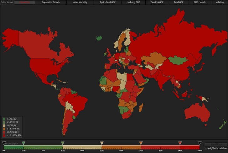
A very slick Flash visualization of CIA world geographic/economic/demographic data called the World Factbook Dashboard; it’s in Flash, so iPad users are out of luck. ;-). Start out with a map of the world, with colors denoting country population:

wfstartingview

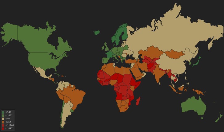
You can adjust color for population ranges by moving the sliders at the bottom; plot a different index by clicking its name at the top, like infant mortality:

wfim

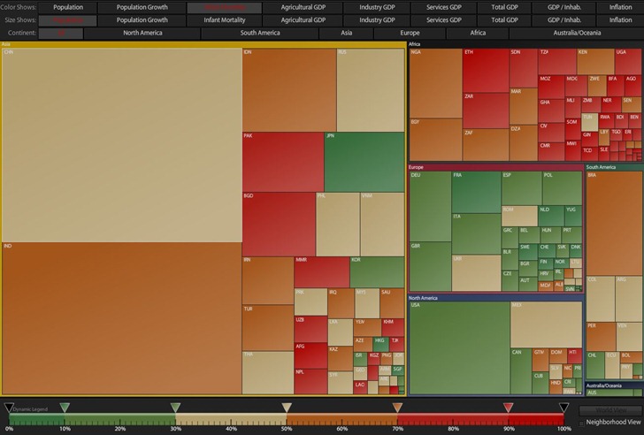
Plot multiple characteristics by clicking on the Treemap tab at top to get a “cartogram”-like view, like this plot where size is proportional to population, and color denotes infant mortality:

treemap

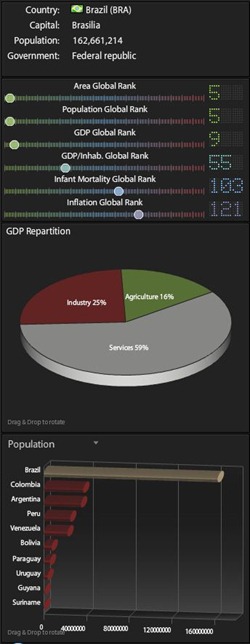
Click on a country in World Map or Treemap mode, and get its worldwide ranking for various parameters, as well as graphic comparisons to neighboring countries for selectable parameters, in a pane at left:

datapane

Lots more stuff to check out. Via Download Squad, which has a ten-minute video demoing some of its features.