blankblank blank


Archive for the 'KML' Category Page 6 of 16


Placemark Creator For Google Earth

A new utility from Valery Hronusov, Placemarker lets you create a Google Earth placemark different than the standard placemarks available in the program. No install program, just unzip the files into their own folder and run the executable:

9-14-2008-10.06.09 PM

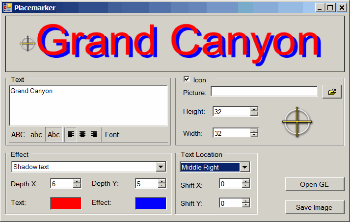
Enter the desired text into the box; controls let you set the font, shadow or outline effects (with variable depth), and the location of the text relative to an optional icon. The default icon is shown above, but you can use JPG, PNG, TIF, BMP and TIF files of your own, and re-size the icon to your desired dimensions. “Save Image” saves the text and marker imagery at top as a graphic file. But if you want to place the text/marker in Google Earth,  click on the Open GE button:

9-14-2008-10.11.37 PM

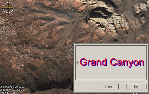
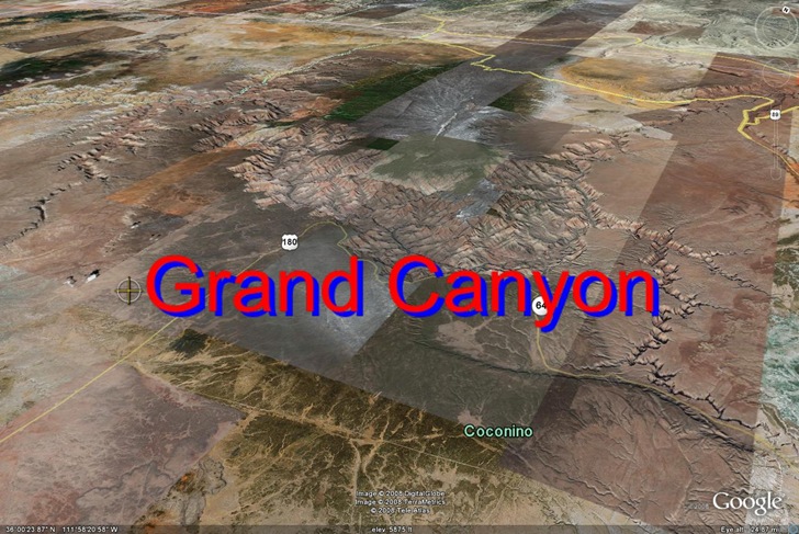
If Google Earth isn’t already open, it will be, a marker will appear at the center of the screen (at upper left in the above picture), and the action box at the lower right. Move the image in Google Earth until the on-screen marker is positioned where you want the placemark to be located, and then click “Do!”. A PNG of the placemark image will be created, and positioned centered at the on-screen marker:

9-14-2008-10.15.30 PM

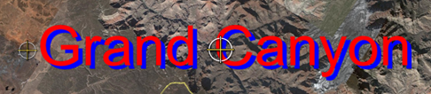
If you don’t like the position, you can move the Google Earth image and “Do!” it again. Once you have it where you want it, just save the generated “image.png” overlay as a Google Earth KMZ file to keep it for future use.

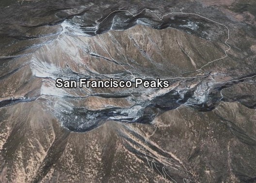
The overlay stays at a 0-degree orientation, and covers the same screen area, regardless of how you tilt the display and zoom in/out:

angled

A useful complement to the online KML Labels tool that generates similar text labels for Google Earth, but as image overlays on top of the terrain.


Online 1:1M Geology Maps At The OneGeology Portal

The OneGeology website gives its mission as:

Make web-accessible the best available geological map data worldwide at a scale of about 1: 1 million, as a geological survey contribution to the International Year of Planet Earth.

While the official launch of the site is scheduled to coincide with the International Geological Conference in Oslo, August 6-14, the mapping portal site is already partially functional, although a few bugs and quirks still exist. It currently works with Internet Explorer 6/7, and Firefox 2, but not Firefox 3 (hope this changes soon). And while the goal is to have data for the whole world at a 1:1,000,000 scale, data for significant areas of the world are currently not available at that scale; for example, the US data is at the 1:5M scale. A partial list of the WMS data available and its scale is on this page.

Continue reading ‘Online 1:1M Geology Maps At The OneGeology Portal’


A Simple Online KML Polygon Creator – With Holes!

Kjell Scharning emailed to let me know of his simple Google Maps tool, a basic digitizer with a Google Maps interface for creating KML polyline and polygon files. While for most purposes, the Google Maps MyMaps creation tool is a better choice, Kjell’s tool does have some useful functions missing from the Google Maps editor:

  • Creating circular shapes
  • Creating polygons with holes in them (something you can’t do directly in Google Earth, either)
  • Get a list of vertex coordinates as created (select the “KML Coordinates option”). There’s also a separate KML “editor” that will take a link to a KML file, and give you a text list of the vertex coordinates. You can move the vertices around in the “editor”, but it doesn’t actually edit the KML, just modify the coordinates in the list.

As you click on the Google Maps interface to create vertices for the polyline or polygon, the KML text will be updated in real-time in a text window to the right of the map:

Google Earth shape with hole

The instructions are a little unclear on hole creation. To create a shape with a hole:

  • Choose the “Polygon” Draw mode
  • Set the style for the shape (color, fill, perimeter) with the “Style options” button, then draw the shape in the map. Be sure to end the shape by clicking the “Close Polyshape” button.
  • Check the “Hole” box; the perimeter of the main shape will turn into a polyline, and the draw mode will switch to “Polyline”.
  • Draw the shape of the hole on the map, using the “Close Polyshape” button to finish the hole.
  • Click the “Polygon” Draw mode option, and you’ll see your original shape with the hole inside of it.

Once you’re done, click the “Select and copy text” button, then paste the code into a text editor and save it as KML file.

It currently only seems to work in Internet Explorer and Firefox 2, but not in Firefox 3. And you can only draw one shape at a time. Not a complete editor by any means, but you may find its unique features handy.


Plot Google Analytics Geographic Data In Google Earth/Maps

Johann Blake writes about his new tool to plot geographic Google Analytics data in Google Earth or Google Maps. Just follow the instructions on the website to export the Analytics data in XML format to your computer, then upload the file to the site. You have the choice of creating either a straight KML file for Google Earth, or a direct plot of the data in Google Maps; the latter doesn’t seem to work currently in Firefox 3, but does work in Internet Explorer. You get placemarks for every country from which you had a visitor, color/type coded by the total number of visitors:

gega

Click on a placemark in either Google Earth or Google Maps to see the number of visitors from that country. You can use the standard Google Analytics controls to select the desired time frame, and also filter data.

It appears as though you can also select geographic sub-regions in Google Analytics like the US states below. I did get a bunch of error messages in Google Maps, and the District Of Columbia plotted in the South Atlantic, before the rest of the states plotted correctly:

7-20-2008-8.55.39 PM

This older tool was able to plot individual visitors, but required a raw data export capability that Google Analytics no longer provides. So for now, Johann’s site is the best available GE/GM Analytics tool.


US Nautical Chart Overlay For Google Earth

Navimatics has created a KML network link that overlays marine charts derived from NOAA data onto Google Earth. Coverage includes all of the US coastline for the contiguous 48 states, but not Alaska and Hawaii yet. From high altitudes, coverage areas are outline with yellow lines:

Continue reading ‘US Nautical Chart Overlay For Google Earth’


Modify A KML Polygon File With Excel Data

Remy Paternoster writes to announce a new tool he’s created, an Excel app called KMLxl that imports a KML polygon/placemark file created in Google Earth, and lets you both attach data to each polygon and scale the height of the polygon to a variable value:

kmlxl

The process is straightforward, involving creating polygons and associated placemarks in Google Earth, importing the KML file into Excel with the app, adding data, and then exporting the results as a new KML file. You can update the Excel spreadsheet at any time with new data, and create a new KML that reflects the newer data. In addition to the app, Remy has an easy-to-follow step-by-step tutorial of the process in an accompanying PDF file.


KML Text Labels For Google Earth

While labeling items in Google Earth, you’re able to modify the font color, size and opacity. But one curious omission is the inability to change the font; you’re stuck with the Google Earth standard:

6-8-2008-4.29.11 PM

The font also stays the same size regardless of how far away you are from the labeled area, which can be useful sometimes. But if you have a lot of labels, this can result in lots of labels overlapping, and cluttering up the image. Label text is also all on one line, which can lead to long labels if you want to include lots of text.

Continue reading ‘KML Text Labels For Google Earth’


An Online KML Validator

A previous post linked to a video on how to add in-line KML validation to the Java-based text editor jEdit. There’s now another KML validation option for those who use their own editor to create KML files. Galdos Systems has created a free online KML validator; just submit a link to an online KML or KMZ file or upload the file from your computer (note: for online files, upper/lowercase matters!). You’ll get back a report page with:

  • The number of errors found, recommendations and suggestions
  • The specific errors found, referenced by line number in the original file
  • A listing of the original KML/KMZ file with line numbers, so you can cross-reference the error specified with the line number

An error doesn’t necessarily mean a fatal error; my test file had three errors, mainly related to spec changes in KML, but works fine in Google Earth. Still, even with a working file, it’s useful to see where it doesn’t conform to specs, and for a non-working file it can help you track down the error.

Via the Google Earth Blog.