blankblank blank


Archive for the 'KML' Category Page 4 of 16


Online Lat/Long – UTM – Grid Coordinate Converter

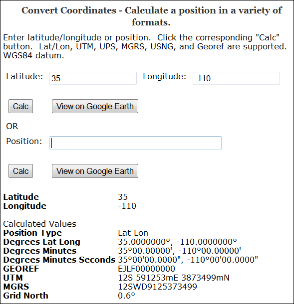
The Earthpoint Coordinate Converter takes a geographic position in latitude/longitude, or in a number of grid coordinate systems, including:

  • UTM
  • MGRS/USNG and MGRS Polar
  • GeoRef

and converts it to all the other coordinate systems (including lat/long in decimal, DDMM and DDMMSS formats):

3-5-2009-8.55.12 PM

(Grid North is the deviation between true north and north along the map projection grid lines)

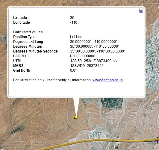
You also have the option of viewing the point in Google Earth, with a pop-up balloon that includes all the coordinate data:

3-5-2009-9.04.06 PM


Digipoint, Export Of Google Maps Point Coordinates, Upgraded To Version 3

I’ve posted before about Digipoint (version 1 and version 2), a web app that lets you select points in a Google Maps interface, then export their coordinates in a variety of formats. Version 3 of Digipoint is now out, with some modest improvements:

  • A new interface, a bit easier to use, and which works better in browsers where the default font size has been modified
  • Fly-to: Specify an address, country, or location, and the map will automatically go there. There are also a limited number of pre-specified country/region links, where  clicking on the link takes you to the area automatically
  • In previous versions, you had to copy/paste text for a particular export format like CSV or KML; you can now download the file automatically
  • For exported shapefiles, a corresponding prj file is also created to specify the coordinate system (your choice of geographic or UTM; WGS84)
  • Help section added

Still supports the same export formats as before: CSV, TXT, TAB, BLN (Surfer), GPX, KML, DXF and shapefile. Versions one and two are still available if you want them, but there’s no good reason to use them anymore.


Online KML To Shapefile Converter

Just got an email from Zonums Software that, after a prolonged hiatus, they’ve resumed development of free stand-alone and web-based geographic tools. I’ve posted previously on their stand-alone KML to shapefile converter, but a glance through that post’s comments will reveal that it has some serious bugs in it. While those are still being fixed, Zonums has released an online KML to shapefile converter:

Continue reading ‘Online KML To Shapefile Converter’


Web Application For Querying NGS Survey Marker Locations And Displaying Them In Google Earth

Not too long ago, I posted about DS World, a Windows app that lets you query a database of National Geodetic Survey markers, and returns a KML file to display them in Google Earth (note: earlier versions of DS World may have problems with Google Earth 5, but the newest one works fine). In comments, the survey firm of Metzger and Willard noted that they’ve created a web app called NGS Control Stations (NGSCS) Radial Search that performs a similar function. Despite the name, it allows search by three different areal selection methods:

Continue reading ‘Web Application For Querying NGS Survey Marker Locations And Displaying Them In Google Earth’


National Geodetic Survey Marker Positions And Info In Google Earth

The US National Geodetic Survey has produced DS World, a free program that can query their database for the positions of geodetic survey marker stations based on either state/county, distance from a fixed coordinate, or Project ID. It then produces a KML file with their locations and loads it into Google Earth. For example, to get county data, choose Stations => By State and County, then select the state and county from the successive dropdown menus that appear:

Continue reading ‘National Geodetic Survey Marker Positions And Info In Google Earth’


Using Apple And Online Tools With Google Earth

I haven’t posted much about Apple-related geography tools on this blog, for two very good reasons:

1. I don’t own any Apple hardware (Mac, iPhone or iTouch)

2. There’s a lot less geographically-oriented software available for the Mac than there is for Windows, or even Linux

But Stefan Geens, who runs the Ogle Earth blog, does have a Mac and and iPhone, and posts regularly on geographic applications for those platforms, usually Google Earth related. And he’s just put up several posts (one, two, three) on how he used these tools along with Google Earth to document a trip in Egypt to visit a number of archaeological sites. The series is very much worth a look, even if you don’t use Apple products:

– The trip itself, and the locations documented, are incredibly interesting, especially if you’re into Egyptian archaeology. In particular, the cubic panoramas embedded in the file, using 360cities.net, are jaw-droppingly spectacular. Stefan documents his panorama-creation process here.

– A number of the tools used are online-based, so they’re not tied to Apple platforms and can be used by anyone

– Valery Hronusov posted a few days ago on his blog about using the DropBox service (free for up to 2 GB of data) to sync a KMZ file on your desktop to your DropBox account, and then create a publicly-accessible URL link to this file that anyone can access. Stefan created such a link to his Egyptian travelogue, demonstrating how you can now have an Internet-accessible KMZ link that updates automatically whenever you change the matching file on your desktop; no FTP or other file upload process required. KMZ is a better choice than KML for most cases, since it compresses the file and also incorporates all of the supporting materials (like photographs).

– Stefan also uses the caching capability of Google Earth on the iPhone, storing GE data for the locations he was going to visit using a WiFi link for use when he couldn’t get a good connection, or when it would have been expensive to do so. This is a good technique to use with Windows laptops as well, if you’d like to use Google Earth in a location where an Internet connection is either unavailable or expensive. I’ve been meaning to do short series on this for a while, and this is as good a prompt as any, so the rest of this week’s posts will be on using Google Earth’s caching capability on a Windows system.

Snow Cover Maps

So, the week of December 15-19, when I was supposed to be out doing field surveys in northern Arizona, we got snow. A lot of snow. And it kept going until about December 26th. It’s kind of hard to do a field survey when the ground is covered with snow, but I’ve been hoping the recent bout of warm weather would melt that snow quickly, and let me get back out in the field.

To monitor that situation, I’ve been consulting the US National Weather Service’s National Operational Hydrological Remote Sensing Center (with the snappy acronym NOHRSC). At this time of year, they supply a large number of snow-related data products, including:

Continue reading ‘Snow Cover Maps’


Battle KML Time Animations For Google Earth

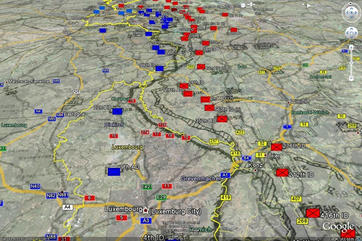
Professor Peter Guth of the US Naval Academy, author of the first-rate terrain analysis and GIS program MicroDEM, writes to let me know that the final projects of one of his classes are available online. Among the projects are KML files for a number of historic battles, including time animations for Antietam, the Battle Of The Bulge, and Dien Bien Phu. These combine both actual historical situation maps as image overlays, and placemarks for unit positions:

Battle Of The Bulge in Google Earth

While you can click the “Play” button on the time animation control, I find it easier to follow the animation by manually moving the time slider over from left to right to follow the progress of the battle.