blankblank blank


Archive for the 'Google Maps' Category Page 14 of 15


Positional Accuracy In Google Maps "My Maps" Vs. Google Earth

I’ve posted before about absolute positional accuracy issues in Google Earth. The Google Earth coordinates corresponding to a feature on the earth can be off from the true coordinates of the feature, about 30 feet in my neck of the woods. With the new Google Maps “My Maps” feature, I was curious as to whether you get any improvement in positional accuracy using Google Maps to create KML files for a point, rather than using Google Earth directly.

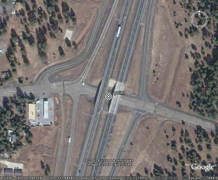
First, I created a point in Google Earth at a highway intersection:
ge

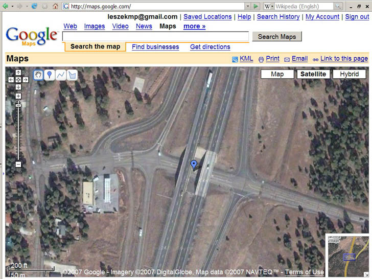
Next, I created a point at the same location in Google Maps “My Maps”:
googlemapswebsite

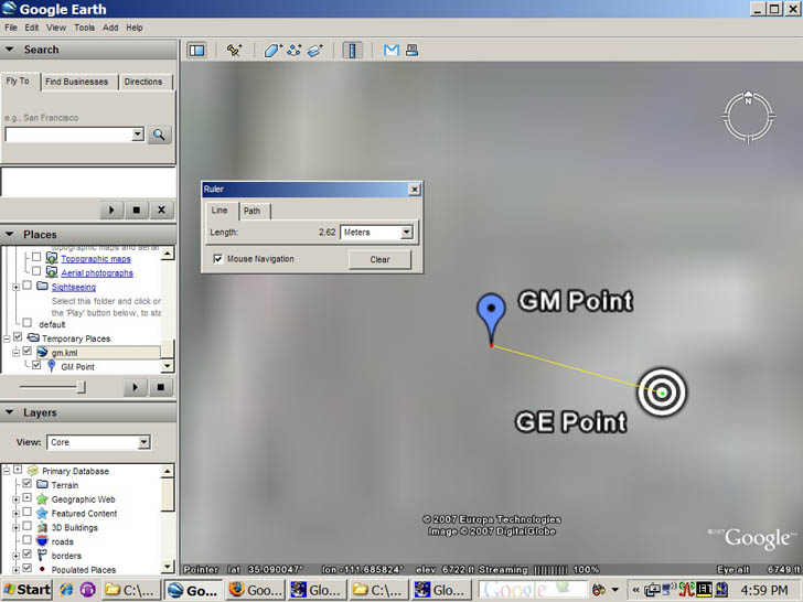
Exporting the Google Maps point as a KML file, bringing it in to Google Earth, enlarging the view, and measuring the difference between the two:
Point positions in Google Earth and Google Maps compared to each other

GM point is from Google Maps, GE Point from Google Earth. There’s a slight differential in the two, about 2.5 meters, but that’s almost certainly due to my inability to position the points exactly in the right location in both images, i.e. I’m a klutz. So coordinates match up reasonably well between Google Earth and Google Maps.

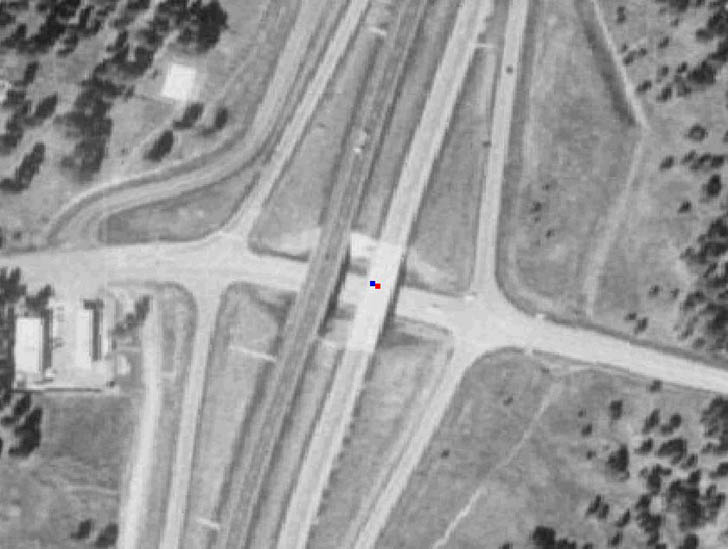
But if I plot these points on top of a georeferenced USGS aerial photo:
Point positions in Google Earth and Google Maps compared to the actual position in a georeferenced map

with blue being the Google Maps point, and red the Google Earth point, you can see they’re displaced from the actual position by about 10 meters, or a bit more than 30 feet. That’s comparable in size and direction to what I saw in my previous post on Google Earth accuracy. So you’ll get consistency if you export data from Google Maps “My Maps” to Google Earth, but the coordinates you get in the Google Maps KML file can still be off from the true values. It wouldn’t surprise me if the magnitude and the direction of the shift varied from place to place; if you’re hoping to use either Google Maps or Google Earth for determining positions with high accuracy, you should definitely do a ground check first to see what degree of coordinate shift there may be in your area.

Note: If you have info about the Google Earth or Google Maps coordinate shift for your area, please post it in the comments section below (location and size of shift).


Google Maps "My Maps" Features

Google Earth Blog posts on Google Maps new “My Maps” feature, which adds additional editing tools to Google Maps and lets you export the created features into a Google Earth layer. Well worth a look.


Sea Level Rise, Storm Surge, And Flooding Effects Using 3DEM

Global warming is predicted to increase the sea level by:

  • About a meter over the next century in the best case (IPCC)
  • 5 meters if the rate of sea level rise continues to accelerate at the same rate it has since 1950 (Hansen)
  • As much as 12 meters in the worse case (melting/collapse of the Greenland and West Antarctic ice sheets) (Gore)

There is also reason to believe that it will increase the number and intensity of hurricanes, which in turn increases the likelihood of coastal flooding due to storm surges, wind and low pressure combining to drive ocean waters inland. And changes in weather patterns may result in increased flooding events. You can take a look at the potential effect of these events using 3DEM.

Continue reading ‘Sea Level Rise, Storm Surge, And Flooding Effects Using 3DEM’


Coordinate, Elevation, Distance And More In Google Maps

In an earlier post, I talked about a website that gives you coordinate data for a point in Google Maps. I’ve just found a website that gives you that information, and more, for any point within Google Maps.
Earth Tools offers up the standard Google Maps interface with position crosshair in the center, and a number of information options for the position marked by the crosshair:

  • Location: Click on this, and get the position both in latitude/longitude (decimal degrees and degrees-minutes-seconds) and the UTM coordinates
  • Height: Give the elevation of that location in feet and meters
  • Time: Gives the local time, and the time zone relative to Universal Time (GMT)
  • Sun: Gives the time for various twilights (Astronomical, Nautical and Civil), and sunrise/sunset
  • Distance: Click on the “Start Measuring” button, and scroll/pan the map – you will get the distance from the original crosshair position to the new one. Click on “Stop Measuring” when you’re done.
  • Places: Enter a place name to search for it from a database of 7.5 million names.

In addition to the regular Google Maps Map-Satellite-Hybrid buttons, there’s a fourth one called Contour that will supposedly overlay a high-resolution contour map on top of the Google Maps display. For my area, coverage wasn’t complete yet, more of a checkerboard pattern; YMMV.

The website also offers the elevation, time, and sunrise/sunset data via a webservice.


Diagramming In Google Maps And Google Earth With Smoot

Smoot is an AJAX-based tool that supposedly allows you to create diagrams with custom icons, and then exporting these diagrams into Google Maps or Google Earth by assigning addresses to the icons. I say supposedly because I can’t test it myself – it requires a webserver running PHP and MYSQL, which I don’t have access to, or the time to set up myself. The website has a demo showing the basics of diagramming, but doesn’t support exporting the diagram onto Google Maps or Google Earth because the website host doesn’t support outbound connections. If anyone tries this out, let me know (and send me a screenshot and description if you can). Thanks!


Panorama, Peak Identification And Viewsheds In Google Earth

OgleEarth posts about Hey, What’s That?, a website that lets you enter a location and then gives you:

  • A panorama of what’s visible from that location, marking the position of peak geographic landmarks
  • A list of the peaks, and the ability to show their position relative to your location on Google Maps
  • Terrain profiles (elevation versus distance from the location to any point on the map)
  • A plot all the areas visible from that location in red on Google Maps (aka the “viewshed” or “weapons fan”)
  • Contour lines (zoom in for these)
  • Google Earth export of position, viewshed, horizon line and horizon extent. If the viewshed area is large, this might strain the memory capacity of lesser systems.

It uses 30-meter SRTM version 1 data for its calculations, so there may be some quirks depending on whether there are holes in the SRTM coverage for your area. They’re switching over to SRTM version 2 soon, which is better but still not perfect. It only works in the US right now, but according to OgleEarth, they hope to expand coverage worldwide. A cool site! Check the OgleEarth posting for more info.


Plot A Coordinate Position On Different Map Pages

If you need to plot a coordinate position quickly on a wide variety of maps from different websites, or if you want to find a list of nearby geocaches, benchmarks, or other info, here’s a neat little website for that:

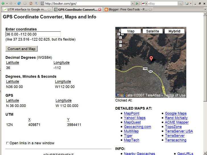
The GPS Coordinate Converter, Maps and Info website lets you enter a set of geographic coordinates (latitude/longitude, WGS84), converts them to decimal/degree-minute-second equivalents and UTM coordinates, and plots the position in a small Google Maps window on the right:

same point plotted in multiple online web mapping apps

The “Enter coordinates” box at the top is fairly flexible, so you can enter coordinates in both decimal and degree-minute-second format.

Although you can select the standard Google Maps display options on the right, Map, Satellite or Hybrid, you can also open up a map for this position from a wide variety of mapping websites, listed below the small map image under the “Detailed Maps At:” heading. Open it on the official Google Maps site, Yahoo Maps, MapQuest, TerraServer, and a whole bunch more.

Below the Detailed Maps links are separate links to geocaching sites, benchmark sites and more; click on these links, and the matching website opens with the coordinate data you’ve entered above automatically passed to the website (in most cases).


Converting Google Maps Search Results To GPX

After my last Google Maps posts, Rich of GPS TrackLog wrote to let me know that there’s a way to convert Google Maps search results (restaurants, Wi-Fi hotspots, etc.) to a GPX file for upload to a GPS. He’s already got a full write-up on the procedure, so I’ll just link to that. Unfortunately, the process doesn’t work with the DigiPoint site, but it appears as though that site’s author is planning direct GPX support in the future. And you can always use the options described in the post to convert the text output to GPX.