

The mapz blog has a great post on mapping-related extensions for Firefox 2.0, and a single extension you can download and install that incorporates all of them.
Archive for the 'Google Maps' Category Page 13 of 15
Once again via Ogle Earth, a nifty little tool called Elevation Mapper. Enter two positions in Google Maps, either by typing them in or clicking on the map, and get an elevation profile between the two:
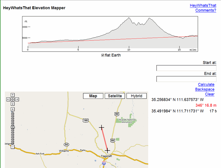
Counterintuitively, the “flat Earth” box needs to be checked for this to work.
If you have a DEM (digital elevation model) for an area, you can create a similar profile using 3DEM, either for a straight line or an arbitrary line/GPS track. With a high-resolution DEM, this would give you a more accurate profile.
Via GISUser.com, a link to the HeatMapAPI website that offers a free basic API (and advanced paid one) to create heat maps:
“a graphical representation of three dimensional data (X, Y and Value) on a two dimensional surface by using colors”.
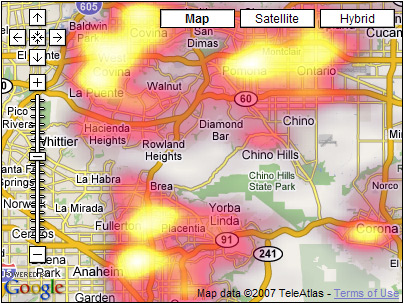
If you have a shapefile, you could create a similar kind of map using Google Map Creator as well.
The fine people at the University College of London’s Centre for Advanced Spatial Analysis, the same ones who released the Google Map Creator described in the previous post, have also released Image Cutter, a program that allows you to use the Google Map pan-and-zoom interface to display a tiled large image at various scales. Written in Java, it will run on Windows, Mac, and Linux.
The obvious applications are for general digital images, where it can be used to view them at both large and small scales. This could be useful for displaying maps where you don’t want or need to have geographic coordinates associated with the map (e.g. a general city or college map, or perhaps an imaginary or unusual map from the Strange Maps blog). The image tiles and associated HTML code can uploaded to and hosted at the webserver of your choice.
There’s a Web 2.0 service called MapLib.Net that performs the same function, but also hosts the images for you. There’s a free account with a max storage space of 30 MB, and a maximum image size of 6000 x 6000 pixels; various paid plans are also available that offer larger image sizes and more storage space.
There are a number of free ways to convert shapefiles to KML format for display in Google Earth, but fewer and less flexible shapefile display options for Google Maps. This site lets you upload small line and polygon shapefiles for display in Google Maps, but not in a permanent form, and with limited display options. This other site details a procedure to display polygon shapefiles in Google Maps, but it’s not particularly straightforward to implement. There’s also some direct support for displaying simple KML files in Google Maps, so you could always try converting the shapefiles to KML and then opening them in Google Maps. But there’s a Java application that makes the process reasonably straightforward for polygon shapefiles, shows the data already loaded in a Google Maps interface, and offers some added display options.
Continue reading ‘Thematic Polygon Shapefile Display In Google Maps’
DigiPoint is a great site for selecting points in Google Maps, and then exporting them as a CSV file for import into a GPS as waypoints using GPSBabel. Once loaded into the GPS, you can create a route using those waypoints, but it would be easier and more convenient if you could create both the points and the route in Google Maps, and then create a GPX route file automatically. And there’s a website that lets you do that.
In addition to the standard image overlays of Map, Satellite and Hybrid for Google Maps, the Active Trails website has an additional overlay button – Topo, for topographic maps. At lower zoom levels, the 1:100K scale USGS topo maps are visible, but if you zoom in close enough, the larger-scale 1:24K maps become visible. Comparing Map, Satellite and Topo overlays, there appears to be a good position match between the three. Active Trails also has placemarks for many kinds of outdoor trails across the country (hiking, biking, equestrian, etc.) entered by site users. You can also install a network link in Google Earth that will let you view the trails there, similar in nature to the new Google Earth layer from Trimble.
Addendum: Fixed the Active Trails links (sorry about that). In the comments, MH points out the ACME Mapper 2.0 site, which is a better choice. It displays black-and-white USGS aerial photos, and also lets you print out a copy of the on-screen map with the push of a button.
Zonum Solutions, the source of such utilities as shp2kml, kml2shp, kml2x, and DigiPoint, has just released another good one. MapTool not only lets you determine the coordinates and elevation of any point in Google Maps, but also lets you measure both distances and area directly in Google Maps as well.
Continue reading ‘Measuring Elevation, Distance And Area In Google Maps’