blankblank blank


Archive for the 'Google Earth' Category Page 13 of 25


Convert TIGER Polygons To KML Files

Bruce Ralston, author of the free TIGER to shapefile conversion utility tgr2shp, has a new program called tgr2kml that converts US Census TIGER file polygons (but not points or lines) into KML files. It works on TIGER files from 1994 to 2006 Second Edition (future TIGER data will be issued directly in shapefile and web formats).

First select the TIGER files you want to process (they can be in zipped format):

Continue reading ‘Convert TIGER Polygons To KML Files’


Interactive US Census Data Viewing In Google Earth With The GE-Census Explorer

Another slick brand-new tool from Zonums Software, the GE-Census Explorer lets you interactively display, plot and analyze US Census data in Google Earth.

The initial interface is deceptively simple:

GE-Census-Explorer

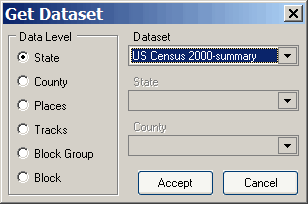
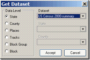
Folder icon at left: “Get Dataset”. Lets you select the geographic extent of the dataset you want to look at:

Get DataSet

Continue reading ‘Interactive US Census Data Viewing In Google Earth With The GE-Census Explorer’


Google Earth Index For US Army Map Service Topographic And City Maps

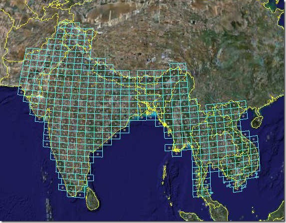
In a previous post on large-format downloadable historical maps, I noted that the Perry-Castaneda Map Library has an interesting digital collection of Army Map Service topographic maps dating from the 1940s and 1950s, covering large areas of Asia and Africa, along with city maps for Japan, China, Korea and Taiwan (Formosa). Over on the Google Earth Community, “PriceCollins” has been creating a KMZ index file for these maps. So far, he has indexed all 435 city maps:

asiacity

And 413 1:250K maps covering most of India, Pakistan and Southeast Asia:

seasiamaps

Each city and rectangle placemark contains a direct download link to the map image at the Perry-Castaneda Library. From the post, it sounds like eventually all the maps will be indexed in this fashion, so it’s worth bookmarking the site and checking it regularly for updates.


"Fair Use" And Google Earth Imagery

I’ve gotten a few comments on my post about importing georeferenced Google Earth imagery into a GIS, talking about the legality of using the imagery in a business context, and pointing out restrictions contained in the Google Earth user license and the general Google Terms Of Service. While my post mentions that the restrictions of the Google Earth license and “fair use” need to be followed when using this imagery, at least one person equated the use of Google Earth imagery in this manner with theft, dismissing both the concept and legal precedents of “fair use”. So I’ll add some additional thoughts on when it’s appropriate to use Google Earth imagery, based both on a layman’s reading of the user license and the principles of “fair use”. I’d welcome further input from anyone who is an expert on issues of copyright and fair use, and also from anyone from Google who wants to give their take on the issue.

By the terms of the recent revision of the license, the Google Earth software can be use both for “personal, non-commercial uses according to these Terms of Service and the Software documentation“, and for businesses, “the Software may be used by you and your employees for internal use according to these Terms of Service and the Software documentation“. The software comes with the ability to export the satellite imagery on-screen, and the Google Earth API comes with the ability to provide the bounds of the onscreen image, so the actual act of creating an georeferenced Google Earth image is not a violation of either the license or the Digital Millennium Copyright Act. In addition, the license states that, “You agree not to use the Software for any bulk printing or downloading of imagery, data or other content“, indicating that limited printing, downloads of imagery and data are acceptable. The ability to create such imagery directly from the Google Earth application using its built-in print and export functions confirms this interpretation, else Google would not have included this functionality.

Addendum (9/18/07): I should add that any use of the imagery requires you to maintain the Google logo and all the copyright notices embedded in the exported image to maintain proper attribution for the source.

The real question of “fair use” here comes down to how the imagery is used. In the general Google Terms of Service, under the “Content in the Services” section, it says:

“You should be aware that Content presented to you as part of the Services, including but not limited to advertisements in the Services and sponsored Content within the Services may be protected by intellectual property rights which are owned by the sponsors or advertisers who provide that Content to Google (or by other persons or companies on their behalf). You may not modify, rent, lease, loan, sell, distribute or create derivative works based on this Content (either in whole or in part) unless you have been specifically told that you may do so by Google or by the owners of that Content, in a separate agreement.”

The restrictions in any such Terms Of Service don’t preempt the use of any material that falls within the bounds of “fair use”, as numerous court cases have determined. Unfortunately, those bounds can be hard to define. I highly recommend the Wikipedia article on fair use and its references for more information on the topic, especially if you’re not familiar with the concept of “fair use”, since some of its implications may surprise you. Generally speaking, copyrighted material like the Google Earth images may be usable by others without explicit permission of the content creators based on the answers to number of questions:

What is the purpose or character of the use? Does it enrich the public by adding something new, or is it merely intended to supersede the original content for profit without adding value? The first falls under fair use, the second doesn’t. Works derivative of other copyrighted material have been ruled to fall within the bounds of “fair use” as long as they don’t supersede the original and provide added value, even when the derivative works are sold commercially.

What is the nature of the copied work? Factual information can’t be copyrighted, but expressions of factual data can be. Even here, it’s not a hard restriction. The Zapruder Kennedy assassination film was copyrighted by Time Magazine, but when they sued the publishers of a book for publishing stills from the film, they lost; publication of this material was held to be in the greater public interest than upholding the copyright.

Is the amount of copyrighted material used significant and substantial? Reproducing a copyrighted work in its entirety is illegal, as in the case of the of the open source Google Earth clone Gaia that planned to use Google Earth imagery, or MP3 music files. Reproducing limited excerpts of copyrighted material is allowable under fair use if appropriate for the context, e.g. the use of Google Earth screenshots found on many websites and blogs, or excerpts of MP3 files when used in music review.

Does use of the copyrighted material significantly impact the work’s value? If you use the imagery to undercut the value of the original copyrighted material, that’s an issue; if you use it in a fashion that doesn’t, that may fall under the provisions of fair use. The classic case concerning this was the Sony Betamax case, where the Supreme Court ruled that videotaping copyrighted material didn’t have such a negative impact, and thus fell under the protection of “fair use”. And this was even despite the broadcaster’s argument that this technology could be used to break the copyright law. The Supremes ruled that if a technology had legal uses, it couldn’t be outlawed just because it might be used in an illegal fashion; you had to prove that its principal use was to foster illegal use of copyrighted material (that’s why Napster got shut down).

No answer to any one of these question precludes use of the material under fair use; conversely, you might think you have a reasonable “fair use” right under all four questions, but a court might disagree. The way I interpret these “fair use” factors relating to Google Earth imagery (and I’m not a copyright lawyer, so this is a layman’s opinion):

– Use of limited amounts of Google Earth imagery for personal or non-commercial GIS usage when not distributed publicly very likely falls within the bounds of “fair use”.

– Use of Google Earth imagery for personal or non-commercial use for public distribution would seem to fall under the rubric of “fair use” when it is of a limited nature, some transformative value is added (e.g. plotting additional data on top of it, or using it as a basis for further explanatory information), and when it doesn’t impact the value of the original imagery. So, for example, plotting shapefile data on top of a Google Earth image in a GIS, and then distributing the resulting image publicly, may fall within the bounds of fair use when it’s not done for profit. Creating a large-area, high-resolution georeferenced mosaic of just the imagery alone, and then posting it for download on your website, even if you don’t charge for it, will in all likelihood earn you a cease-and-desist letter from Google, and for good cause.

– The legality of internal use of Google Earth imagery in a GIS for commercial purposes conceivably could depend on the usage, but this is a gray area shading towards black. Talk to your legal department, and be prepared for them to legitimately say “no” to any such use.

– Public use of Google Earth imagery in commercial settings likely falls under “fair use” in some cases, e.g. screenshots of Google Earth imagery for illustrative or informative purposes on a website or blog that earns revenue from displaying ads. Google has acknowledged and featured the work of several blogs that exhibit such screenshots along with ads. Beyond that, though, the legality of public use of Google Earth imagery in a commercial setting will depend on the answers to the “fair use” question above, which lies within the domain of copyright law. My guess would be that more often than not it doesn’t qualify as “fair use”, and even if you think it does, it probably doesn’t. Talk to your lawyers. I might add that if you really want to use satellite imagery for public commercial purposes, you’d be better off looking at using Google Maps instead, since the license and TOS allow for some commercial use of essentially the same satellite imagery you’ll find in Google Earth.



Importing Google Earth Imagery Into A GIS

This post has gotten a very strong reaction from many people, mostly negative. They say use of Google Earth imagery in the manner outlined here is inappropriate, an illegal violation of the Google Earth EULA/TOS. More specifically, words like “theft”, “stealing” and “dirty” have been used to describe this. I feel that this use of Google Earth imagery for personal and non-commercial uses falls under the guidelines of “fair use”, and I explain why here. “Fair use” is not theft. But I acknowledge that I could very well be wrong about this falling under the umbrella of “fair use” protection, in which case it would be illegal. I’d welcome opinions from those knowledgeable about the rights and limitations of “fair use”, and will pull the post if an expert on these issues says that using Google Earth imagery as described below doesn’t constitute “fair use”.

You can save the displayed view in Google Earth by using the File=> Save => Save Image command (Ctrl-Alt-S is the shortcut), which saves the contents of the view window as a JPG file. But in order to use this image in a GIS program, it has to be georeferenced, i.e. coordinates assigned to the pixels. There are free image georeferencing options out there, and I’ll cover some of those soon, but that’s not necessary in this case – there’s a simpler way to get the georeferencing data for an image exported from Google Earth.

You will need to have installed Google Earth (of course), the free GIS program MapWindow, and the Shape2Earth plugin for MapWindow. Shape2Earth’s main function is converting shapefiles to Google Earth KML files, and while the full version costs $29.95, it will work in unregistered demo mode for up to 500 shapefile vertices, and here for georeferencing Google Earth imagery.

1. Open Google Earth, and zoom in to the area of interest.

2. Double-click on the “N” in the compass at the upper right to orient north to the top of the screen. Also double-click on the “0 tilt” icon (the box with the “X” in it on the left in the tilt adjustor) to set the tilt angle to zero.

3. Open MapWindow; if you haven’t already activated the Shape2Earth plugin, do so from the plugins menu.

4. From the Shape2Earth menu in MapWindow, select “Get Image from GE”, and click on the “Capture Image” button. If you haven’t already oriented the image with north at the top and zero tilt, you will be prompted to do so.

5. Save the image with the desired name as a JPG file. This will save a black-and-white jpg image of the current view in the Google Earth window, along with a worldfile (*.jpgw) containing the georeferencing information.

6. Go back to Google Earth, and without moving or changing the view in any way, save the current view (File => Save => Save Image) with the same name and location as the image in step 5,. This overwrites the previous black-and-white image with a color one of exactly the same area.

You now have the Google Earth image with the georeferencing data contained in the worldfile (geographic coordinates, WGS84 datum), which most GIS programs can open and read successfully. If there’s a problem, try changing the extension of the worldfile from *.jpgw to *.jgw.

Limitations of this approach:

  • The view in Google Earth is orthographic, i.e. you’re looking at a sphere from above. For views that are zoomed to view a relatively small area, the area is essentially a flat plane, and the georeferenced image shouldn’t have a large deviation from the true coordinates. The larger the area covered, the greater the deviation between the true and georeferenced coordinates.
  • Coordinates in Google Earth can be off from the true coordinates even for small areas; see this post for more info. This process doesn’t correct for any such deviation.
  • Imagery in Google Earth is copyrighted, and using it for any other purpose than viewing in Google Earth falls under the restrictions of copyright law and fair use. In particular, you have to leave the Google logo and copyright notices unaltered to maintain proper attribution.


Geographic Time Animations

While I was writing the previous post on xls2kml, which has the ability to add time data to point placemarks in a Google Earth KML file, I got an email from someone who was looking for ways to create time-animated geographic displays. Digging through my brain and bookmarks, I came up with the following:

– If you have ArcGIS 9.2, there’s a free extension called TimeSlider from Applied Science Associates that lets you animated multiple data series that have associated dates or times. Haven’t tried it myself (I’m still stuck with 8.2).

TimeMap, from the University of Sydney’s Archaeological Computing Laboratory, creates time-based web mapping displays. From the “About” page:

“TimeMap TMJava is a novel mapping applet which generates complete interactive maps with a few simple lines of html. It provides a way of easily enriching web pages with historical or contemporary information that goes far beyond static jpg map images. It’s easy for beginners, yet provides completely customizable power and distributed backend database connectivity for the expert. It’s free for personal use.

TimeMap’s unique time-handling provides an engaging and intuitive method of delivering historical, community, government, research and business information. Combining mapping and the time dimension gives new ways of visualizing urban growth, the spread of empires, heritage sites, environmental change, weather patterns, traffic flow, earthquakes, mobile network faults, and much more ? ranging in time scale from millions of years to seconds.

TimeMap time-filters and animates maps on the fly, connects to datasets anywhere on the web and can search for and load thousands of local maps dynamically as you zoom and pan. TimeMap can filter huge datasets server-side and download only the data needed, or work standalone off a CD. It adapts legends dynamically as scale changes and generates hyperlinks on-the-fly between objects on the map and web pages, and is completely customizable with XML. Yet the applet weighs in at only 350K! ”

The TimeMap website has downloads, documentation, and sample applications. An open source version is on the way. Haven’t tried it this one yet either, but may post on it at greater depth in the future.

– Google Earth, of course, has added time-related coding to KML. But you still can’t add time information to data using the Google Earth application itself. Options for adding time coding are:

  • Add the time data manually to the KML file, as I did in my earlier sea level rise animations; this is currently the only option I know of for animating image overlays, and path/polygon KML files.
  • Use xls2kml to timecode point locations
  • Create a Google KML network link using Google Spreadsheets with timecoding added to point placemarks; Google has a tutorial page describing how to do this.
  • Create a KML network link to an EditGrid spreadsheet; OgleEarth has more info.
  • And I’m working on another way to create animated Google Earth KML files; more on this when it’s ready …

9/25/2007: Added info on EditGrid spreadsheets.


Google Maps Line Tool Now Supports Distance Measurement

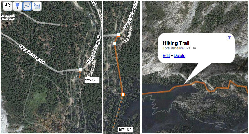
The official Google LatLong blog has announced that the Google Maps line tool in MyMaps now displays the total line length as you draw it, and also adds the line length to the pop-up info box for that line:

Google Maps line tool shows distance
The latest version of Google Earth still doesn’t do that, but I have to believe that capability will be added at some point. Until then, try one of these tools for measuring path lengths in Google Earth.


XLS2KML – Another Excel To KML Converter, With A Few Extras

Note: Original website seems to have disappeared; I’ve uploaded a copy of the spreadsheet here.

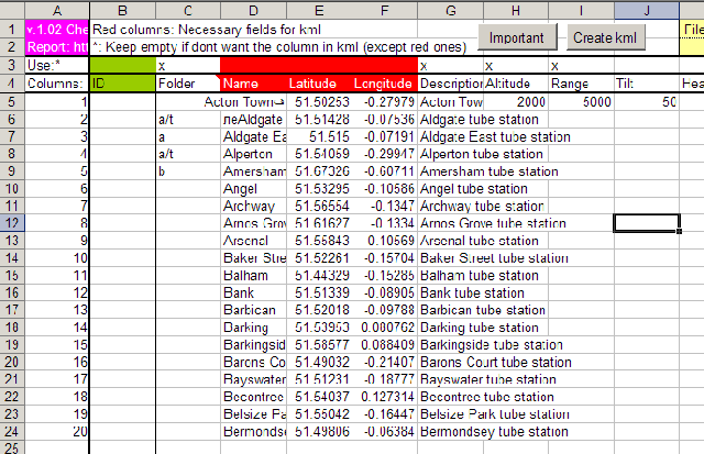
I’ve posted before on several programs and websites that will convert spreadsheet point coordinate data (CSV or XLS) to Google Earth’s KML format (here and here). XLS2KML is another option, but it does a few things the others don’t:

– You can have additional data fields automatically appended to the Description section in the KML file

– You can automatically put points into folders and subfolders

– Columns labeled with case-insensitive KML descriptors (like Altitude, Range, Tilt, Heading, Icon, Time Start and End (for Timespan), etc. will have their data properly encoded in the proper KML format for that descriptor

– There are additional options for drawing paths, polygons and grids from this Excel spreadsheet, but they’re not well-documented with recently-added documentation. Still, you’d probably be better off converting line and polygon shapefiles into KML for the first two, or using GE-Path to create paths, polygons and grids, rather than doing it point by point with this method.

xls2kml

Download the spreadsheet from this site (see the link at the bottom). Click on the “Important” button near the top of the spreadsheet to get what little “Help” information come with this Excel macro-enabled spreadsheet.