

Although it’s primarily aimed at bicycling Garmin Edge/Forerunner owners, Bike Route Toaster is a useful tool for any GPS user, or anyone planning a bike road trip. Create a course in a Google Maps interface by adding points along the route; Bike Route Toaster gives you the option of auto-routing, where it connects the points along roads and adds directions:
Archive for the 'Garmin' Category Page 9 of 13
I’ve posted previously about Moagu, my utility that converts raster map imagery into raster-format maps for some Garmin GPS units. Moagu creates a true bitmap image for Garmin units, with advantages (accurate map and photo reproduction) and disadvantages (slow display times). An alternative approach is to convert a raster image into many small vector polygons, then code those vector polygons as a Garmin-format map. While this approach can speed up display time dramatically, it can also be harder to get good results. There’s a commercial software package called Mapwel that can do this, but I’ve recently been made aware of a freeware program called BMap2MP that also converts raster images into vector polygons, and creates map code for those polygons in the .mp Polish map format. This code can then be compiled into Garmin .img map files using the free or paid versions of cgpsmapper. I’ve spend some time playing with this program, and comparing its results with comparable maps from Moagu.
Continue reading ‘Converting Raster Maps To Garmin Vector Format With BMap2MP’
I did a series of posts a while back on creating custom waypoint icons for compatible Garmin GPS units. If you don’t have the time or patience to make them yourself, there are several free sets of custom waypoint icons available online:
- Western Maps LLC has a set of icons (original size is 16×16 pixels; the magenta color is transparent on the GPS display):
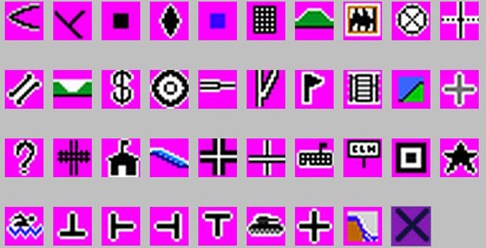
- The Elsinga family website has sets of icons for geocaching, marine navigation, miscellaneous, and speedtraps:

- This site has IALA marine symbols:

See my original series for info on how to upload these to your Garmin GPS, and use them in the MapSource program.
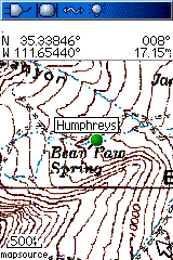
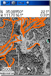
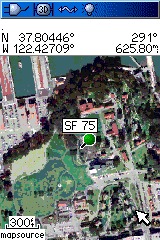
Garmin handheld GPS units use vector graphics to display imagery, so it’s generally been considered impossible to view raster imagery on them, like USGS topo maps or aerial photographs. But I’ve figured out a way, and created a program that lets you convert free USGS topo maps downloaded from the Seamless Server, black-and-white DOQQs, color satellite imagery, any georeferenced raster imagery, to a Garmin-compatible format: Moagu – the Mother Of All GPS Utilities. Rich Owings has the first review at GPS Tracklog (he likes it!).
Here’s a few screenshots from my Garmin 60Cx:
 |
 |
 |
You can download a demo version at the website. Introductory price is $19.95.
POILoader: A long and involved post of mine from a few weeks back described methods for managing multiple custom POI files on a Garmin GPS, to get around the limitation that POILoader erased the current POI set when uploading a new one. The process was mildly painful, involving going into the GPS’s memory, then copying and renaming the *.gpi POI files to prevent them from being erased; I refer you to that post for the gory details. The latest version of the POILoader makes this process a lot simpler: you now have the option of saving the *.gpi files directly on your computer, where you can rename and manage them directly before copying them into the /Garmin/POI directory on your GPS unit. A lot easier.
Curiously, there’s one additional option in the program, which lets you install the POIs into Garmin’s MapSource program under a specific name. It’s curious because there’s no current support in MapSource for POI uploading; I’d look for that capability in an upcoming release.
DNRGarmin: In comments on this post, Thomas notes that the bug that kept USB connectivity in DNRGarmin non-functional unless you installed with administrator rights has been fixed; it now works with any installation. If you have a Garmin handheld GPS, the latest version of DNRGarmin is a must. You can upload data from GPX, Google Earth’s KML format, text, DBF and shapefile to your Garmin using this program, and conversely save data from your GPS in these formats; it can even re-project data in UTM, Lambert, etc. to geographic coordinates for. Even if you don’t have a Garmin, it’s a handy program to have for converting from one format to another.
Dan Bloomberg wrote to tell me of his new website, the GPS File Depot. Some useful stuff for GPS users, especially Garmin owners:
- This has been generally reported, but I’ll throw it in: 1:24K-equivalent Garmin topographic maps for all of Arizona (with all the bugs fixed). Looks like the process has been automated (at least partially), so hopefully more states will come.
- A set of links to collections of high-res Garmin state topographic map collections, free and paid.
- GPS Sway, a small (30 kB) simple converter from latitude/longitude to UTM coordinates and back, and converts from DDMMSS to decimal and back.
- An online tool that takes CSV files generated by the USGS’s Geographic Names Information System page (search for gazetteer features by location and type), and converts them to GPX files for your GPS.
- Image hosting for GPS-related pictures (maps, screenshots, etc.)
Last week, I posted on how to convert a point shapefile to a Garmin custom POI file, and how with some manipulation you could include a fair number of the shapefile attributes in that POI’s data screen. But with only 6 lines of dataspace available, and only about 20 or so characters per line, you can only fit so much data onto a single data screen before you run out of space. And there may be times when you need to fit in more data.
The solution is pretty straightforward – just create another set of data for the same set of POIs, and give this new dataset a different name. It’s easy to access this new dataset using standard POI database management; you can make it even easier to distinguish between different datasets by modifying the point name slightly, appending a letter or number to every POI name in the new dataset, distinguishing it from other datasets with the same name. Using this technique, and using a Garmin that takes external data cards, there’s virtually no limit to the amount of attribute data you can include for every point in a shapefile.
3/6/2010: The newer Colorado/Oregon/Dakota GPS units can store and display more data; see this Oregon Wiki page for more information. So you can now incorporate far more shapefile attribute data into the POI information section than with earlier GPS models.
Garmin POIs (Points of Interest) datafiles can contain up to two lines of text data for the name, and up to four lines of data for the description, far more than the more limited space for the same data in a GPS waypoint. This gives you enough room to include at least some of a point shapefile’s tabular attribute data for a location, and take it into the field with you for reference. And while there’s typically a limit of 500 to 1000 waypoints on many Garmin GPS units, you can put tens of thousands of locations into a POI file, along with that associated data. Here’s one way to create Garmin POI files from a point shapefile, though you could use comparable tabular data as well.
Continue reading ‘Creating A Garmin GPS Points Of Interest (POI) File From A Point Shapefile’