blankblank blank


Archive for the 'cartography' Category Page 6 of 14


Full Natural Earth Data Now Available – Free Vector And Raster Data For The Entire World

Tom Patterson’s raster Natural Earth data has been available for a while, and it’s now been joined by the Natural Earth vector datasets, a joint project with Nathaniel Kelso and others; there’s now also a new home for both datasets at the Natural Earth website. Vector data is available at 1:10 million, 1:50 million and 1:110 million scales. Vector data features include:

  • Country boundaries
  • Administrative boundaries
  • Populated places
  • Coastlines
  • Lakes and rivers
  • Glaciated areas
  • Bathymetry
  • Latitude/longitude graticules

… and much more; see the full feature set description for details. Vector data is in standard shapefile format, geographic/WGS84 projection. The authors solicit both additions and corrections to the dataset. It’s good to have a high-quality free dataset of this type available in one place; while you can find comparable or even higher-quality data on the Web, it usually involves quite a bit of searching.


New Books For Geography Fans

I’ve been a big fan of Frank Jacobs’ Strange Maps blog for several years now, and he’s now collected many of these maps and posts into a single fantastic volume called, appropriately, Strange Maps. Highly recommended for cartographers and map fans.
John Graham-Cumming’s compendium of places of interest for tech geeks and nerds (e.g. Bletchley Park, Chernobyl, the MIT Museum), but with a few points of interest for geogeeks as well (Greenwich Observatory, Gaithersburg International Latitude Observatory, the Arago Medallions that mark the French meridian).
The Natural World Of Saint Francis of Assisi describes how geography and its impact on the natural and cultural world of Umbria in Italy shaped the life and thinking of Saint Francis, one of the most influential figures in Roman Catholic history. Text by the award-winning natural history writer Susan Bean; great photography by National Geographic and Arizona Highways photographer Tom Bean.

“The beauty of Umbria that inspired Francis is still there today, as you will see in the evocative words of Susan Lamb and the remarkable photographs of Tom Bean. The rocks and landscapes, the winds and climate, the rivers, lakes and marshes, the plants and animals of Umbria and the neighboring parts of Italy are all brought to life in this book. ” – Dr. Walter Alvarez, Earth & Planetary Science Department, UC Berkeley


Historical Marker Database

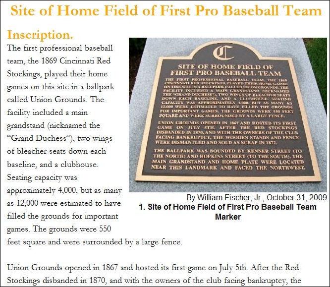
The Historical Marker Database (HMdb.org) is a voluntary effort to document and catalog historical markers, mainly from the US and Canada (a few markers from foreign countries are also listed). Markers are listed by category and state; you can also search by multiple parameters (keywords, postal code, county, etc.). Marker info pages have a photo of the marker, a copy of the marker text …

histmarker

… latitude/longitude of the marker, a context photo showing the general surroundings of the marker, and a list of other nearby markers. A link will take you to a Google Maps page showing the location of the marker and other nearby markers; a link at the top of the map page will let you download a GPX file with all the marker positions for upload to your GPS unit (TomTom POI files are also available). There’s even a custom version of the page for mobile phone; enter your latitude/longitude and get a listing of up to 20 markers near your current location.

The site also accepts submissions of historical makers not yet in the database (requires free registration).


The Big List Of Image Registration / Georeferencing Software

If you want to use a raster map image in a GIS program, it needs to be calibrated so that the software will know the geographic position of every pixel in the image. This calibration data can be embedded in the file, as in GeoTiffs and MRSID files, or external as in worldfiles. If you have a raster map image which doesn’t include this calibration data, you’ll need to create it yourself; this process is called  “image registration” or georeferencing. There’s a number of free programs that can perform this function, and I’ve put together a list of some of them below; if you know of others, please let me know and I’ll add them. And if I’ve included a program that doesn’t do georeferencing (very possible, since I haven’t used all of them), let me know that as well and I’ll drop it from the list.

One thing to keep in mind: some of the programs only work correctly if the map image is already in a specific map projection like UTM or geographic, and you use the same coordinate system to georeference the image. As a general practice, it’s always best to use the same coordinate system the map was created in to georeference it. For example, if you have a map in the UTM projection, and use geographic coordinates to georeference it, the resulting calibration is unlikely to be accurate over the entire map (unless you’re at the equator). Some programs let you warp the map image to get it to match the coordinate system, a process known as “rubber-sheeting”; this is especially useful for those maps that aren’t drawn accurately, like old or hand-drawn maps, or maps created in no-longer-used coordinate systems.

BTW, I haven’t used most of these for georeferencing – GlobalMapper is my program of choice for this function. It’s not free, or even cheap, but it works great for georeferencing, including rubber sheeting. For beginners, I’d suggest looking at MapWindow, qGIS or MicroDEM first before going on to the more advanced software.

CHIPS For Windows

DIVA GIS

e-Foto

GRASS

gvSIG

HyperCube

ILWIS

Image Georeferencer

LandSerf

MapWindow

MicroDEM

MicroMSI (link may be dead)

Opticks

OSSIM

qGIS

QLandKarte

RasterStretch

Regeemy

SAGA

SavGIS

Spring GIS

TransGen

xBit

Online map rectification tools

MapWarper

Metacarta Map Rectifier

NYPL Map Rectifier

Old Maps Online Georeferencer (in development)


Mapping Anthropogenic Biomes

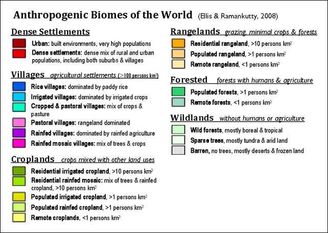
Yesterday’s post was about a site that categorized biomes with very fine divisions based on vegetation, soil moisture, surface lithology, etc., all with the underlying concept that for most areas this was a representation of an actual natural biome. The creators of the concept of anthropogenic biomes go in a different direction; they believe that the impact of man upon the natural landscape has been so profound, with only about 11% of the earth’s surface still truly6 wild,  that most of the biomes of the world must be described by at least partially including the effects of mankind. They’ve broken down biomes into just 21 categories:

Anthro_biomes_legend_v2

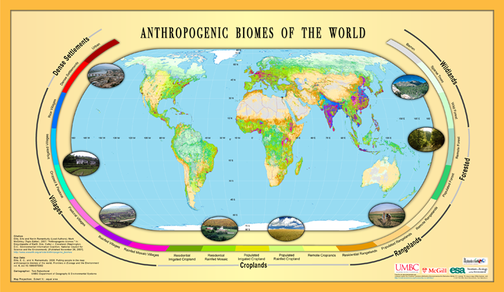
And created a world map using these categories:

anthrome_map_v1

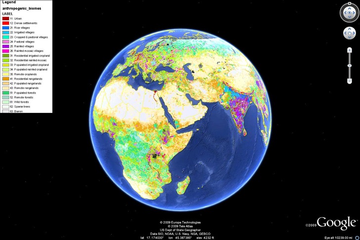
You can download a PDF of the above image, an ArcGrid file for use in ArcGIS, or a KML file for viewing in Google Earth on this page. Viewed in Google Earth:

anthrobiomes

Also available are map viewers for this data in Google Maps and Virtual Earth (latter didn’t work on Firefox for me).

You can watch a Discovery Channel video on the concept of anthropogenic biomes here.

Via Highly Allochthonous.


Simplified Scree Shading For Maps

While good shaded relief is still a cartographic art (see the Shaded Relief and Relief Shading websites for more info), programs like 3DEM, MicroDEM and others can create decent shaded relief effects using digital elevation models (DEM) to shade raster graphic files. Here’s a sample USGS topo map shaded using 3DEM:
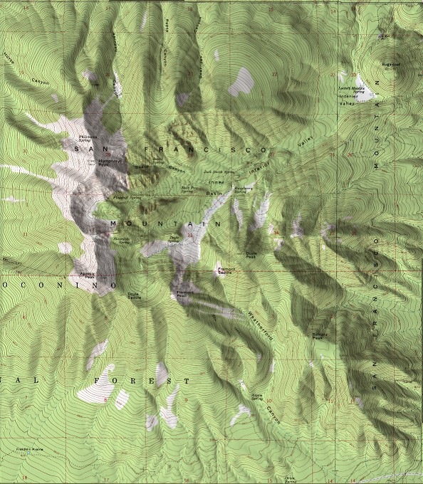
toporeliefshaded

Another style of relief shading is scree shading, also called Swiss-style; it involves drawing small dots representing rocks on maps to provide texturing. In the past, there’s been no way to automate this process, so the only way to do it was by hand, a slow and time-consuming process. Bernhard Jenny of the Swiss ETH has recently introduced Scree Painter, a Java program (Windows, Mac and Linux) that, while not exactly fully automating the process or making it simple, at least makes it far more practical. Mandatory data required includes:

  • A mask to define the size of stones (raster grayscale image with worldfile); darker areas will have larger stones
  • A DEM (ESRI ASCII Grid format) to define gullies
  • Shapefile polygons to define where scree stones will be placed
  • A raster obstacle mask (with worldfile) where black defines areas where no stones will be placed; sometimes this can be the main raster map image

Optional data includes gully lines, a background reference image, and gradation and large stones masks. Once the data is loaded in, sliders let you vary parameters that change the density, shading and shadowing of stones. You can download a sample dataset to play with from the website. Here’s the original map:

original

Using a shaded relief program, I could convert this into:
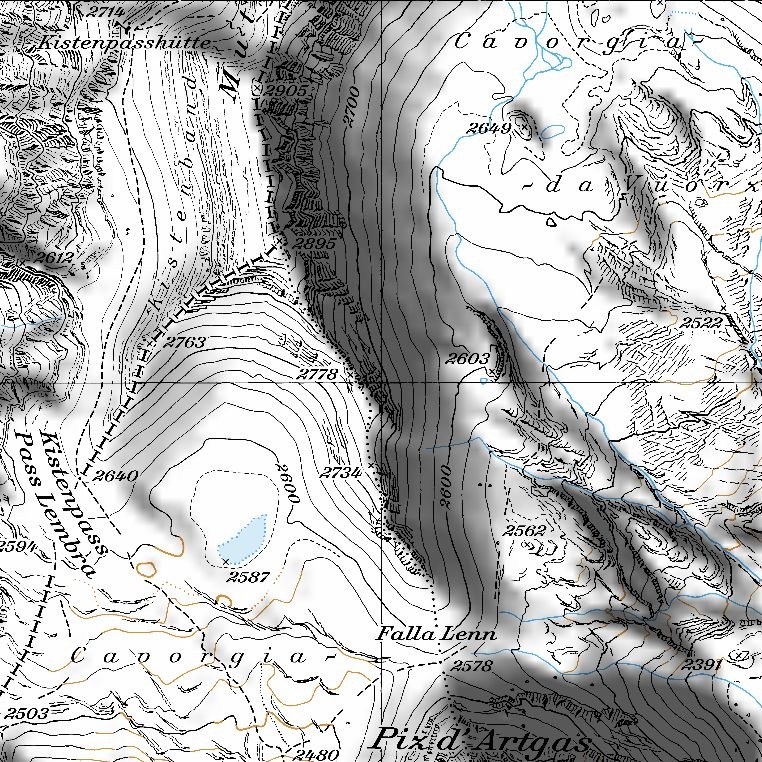
reliefshaded

But by loading it into Scree Painter, and randomly selecting some  parameters, I can get this:
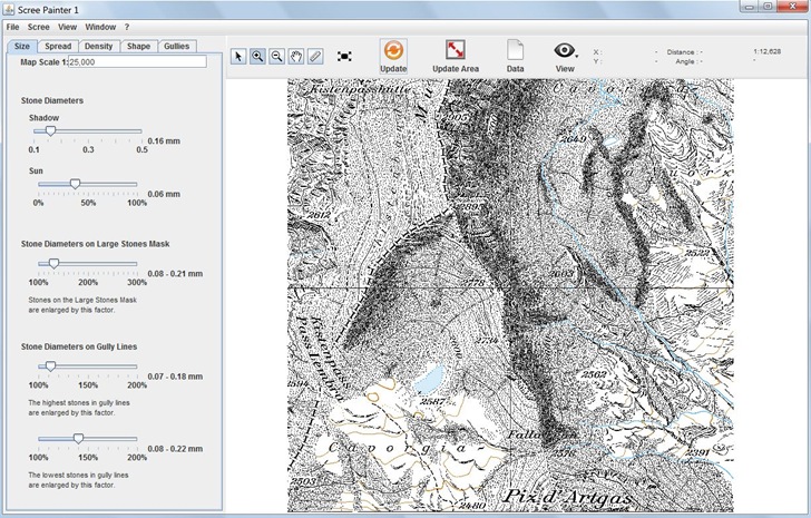
screepainter

Not every good, but then I didn’t try very hard. The sample data includes a reference image that shows what the program is capable of:
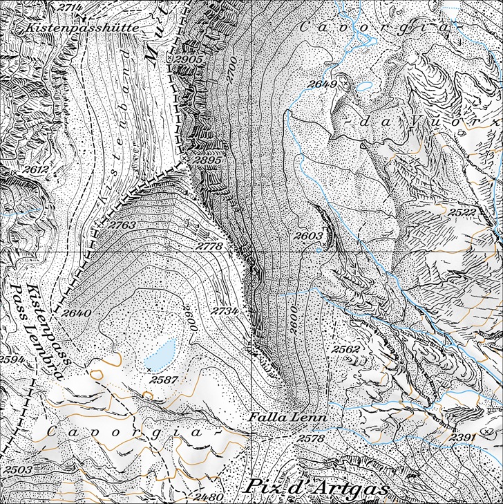
reference

Unfortunately, it doesn’t appear as though you can export the full original map with generated scree and gullies directly. You can export the scree and gully data in a variety of vector and raster format, but you then have to re-combine this data with the original map using a GIS or graphics program to get a result that looks like the one above. Hopefully the author will add the option to export the full image in a georeferenced format in the future.

Via Kelso’s Corner.


ColorBrewer Updated To Version 2.0 – Add-On To ArcMap Available

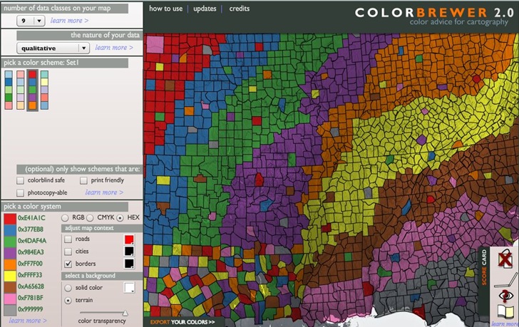
ColorBrewer is an online Flash app designed to help select appropriate data coloring schemes for maps, including sequential (choropleths), diverging (data with break points), and qualitative (discrete categorical data). I’ve covered version 1.0 before, and now ColorBrewer 2.0 is out. Not a huge number of functional differences, but some useful additions (and one disappointing subtraction):

  • More parameters are selected by drop-down boxes instead of buttons; bit faster this way
  • All controls are on the left side, making them easier to find
  • You can now choose between a colored background and a terrain background
  • Color transparency can now be set between 0 and 100%
  • More choices for background, road, city and border colors
  • You can now screen color schemes by appropriateness for color blindness, photocopying and print. In version 1.0, you only had icons showing which uses were appropriate, and these are still available in the “Score Card” tab at lower right
  • More options for color scheme export directly from the program, including an Excel file of all available color schemes, export in Adobe Swatch Exchange format (ASE), and in-program text hex color codes for copying and pasting into graphics programs.
  • No more map zoom; I miss this option.

Here’s a screenshot of 2.0:

cb2

The National Cancer Institute has taken the ColorBrewer color ramps and incorporated them into ColorTool, a free plugin for ArcMap. From the website:

The program runs from a button in the toolbar and opens a form that guides the user in choosing a classification scheme…. ColorTool supports Quantile, Equal Interval, Natural Breaks (Jenks), and Unique Value classification types…. There are also legend options, area borders, and exclusion statements in the tool. ColorTool simplifies the display process by offering preset color schemes and eliminating incompatible options.


Free Outline Maps

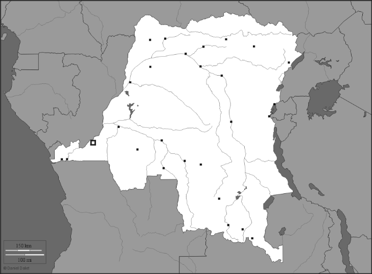
d-maps.com offers over 4000 outline maps of countries/regions of the world, each available in 6 different formats:

  • GIF (Note: to acquire the image in this format, right-click  on the map image and save it)
  • PDF
  • CDR (Corel Vector Graphic Drawing)
  • AI (Adobe Illustrator)
  • SVG (Scalable Vector Graphics)
  • WMF (Windows Meta Format)

Some maps are partially colored in, others just black and white. Maps can include just country borders, or more information like cities, provinces, hydrographic data, and more:

rdc13

A small handful of historic maps as well, in an eclectic set of topics. The total number of maps is growing, so check back on a regular basis.

Via Catholicgauze.