blankblank blank


Archive for the 'cartography' Category Page 12 of 14


Downloadable Large-Format Historical Maps

There are a number of websites that have historic older maps available for online viewing (I’ll list a few of these in an upcoming post), but these sites typically don’t have the maps in high-resolution downloadable formats. You can always zoom in to the highest resolution, do a screen capture, then mosaic the images together if you have the time and patience. But there are a number of websites that do offer downloads of historic (and recent maps) in a high-resolution format. For some maps, a download link will be offered; for others, you’ll have to either right-click on a link to save the map to your computer, or open the image in your browser and then save it to your computer by right-clicking on the image.

Some maps are available in uncommon formats, like MRSid (*.sid), ECW (*.ecw) or JPEG2000 (*.jp2). If your graphics editor can’t open these formats, you can use the TatukGIS Viewer or IrfanView (with the additional plug-ins) to open these files and convert them to a more familiar format like TIF or JPG. Many maps are also available at the highest resolution in PDF format, and you can use a program like PDFCreator to convert them to standard image formats.

Library Of Congress: The US Library Of Congress has an enormous online collection of maps, historic and modern, for the US and the world, searchable and browsable by geographic area, keyword, subject, creator, and title. Most maps are downloadable in the MRSid format in very high resolution, but can also be viewed at various zoom levels online.

The Perry-Castaneda Map Library: Based at the University of Texas in Austin, this site offers modern and historical maps of the entire world at a wide variety of resolutions, mainly in JPG format but some in PDF as well. There’s also a large number of Texas maps (no surprise), and links to additional web map resources. I found the Army Map Service topographical maps of particular interest: 1:250K topo maps of many areas for which topo maps are difficult to find (Africa, Burma, Siberia, and more).

Leen Helmink: Website of a dealer in rare and antique maps, with high-resolution scans of historic maps from around the world, many for sale.

Yale University Map Library: A number of their historical and current maps are available for download in the JPEG2000 format (with more being added all the time).
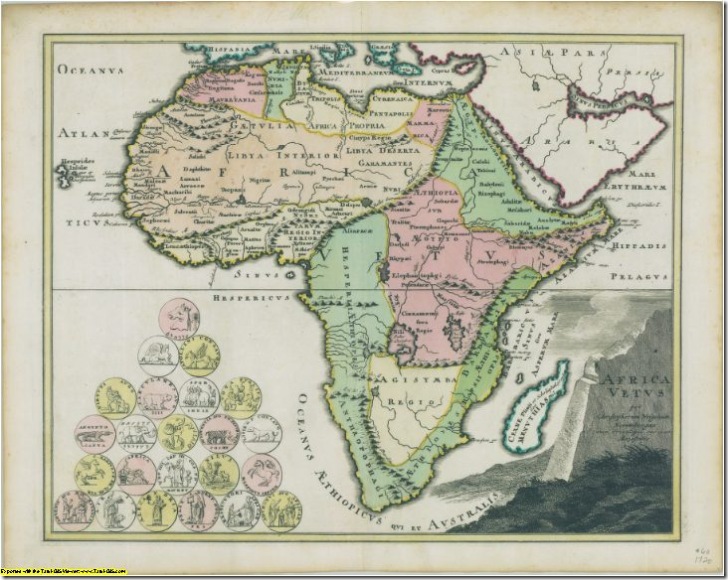
historic map of Africa

Africa map from Yale collection (resized 10x smaller than the original in pixel dimensions, 100x smaller in pixel area)

University Of Connecticut: Many historic maps, primarily of the New England and Mid-Atlantic region, most both viewable online and downloadable in MRSid format.

The Atlas Of Canada: Modern and historic maps of Canada, many (but not all) downloadable in JPG and PDF formats; check the bottom of the individual map pages to see if there are download links available. PDF maps are usually of higher quality than JPG.

Michigan State University: Primarily maps of Michigan, but some maps of Africa and North America.

Quebec National Library And Archives: In French, but you should be able to get around. Mainly maps of Canada and North America, browsable by titles (“titres”), authors (“autheurs”), by time (“chronologique”) and area (“toponyme”). Look for the link titled “la carte agrandie” to open the map image at full resolution in a new window, then right-click on the image to save it.

W. M. Keck Earth Sciences and Mining Research Information Center: Large selection of historic and modern maps of Nevada and surrounding areas.

Know of a good site that I’ve missed? Post it in the comments, and I’ll do a follow-up post later.


Stand-Alone Map Projection Viewers III – MicroDEM

In addition to its primary terrain analysis functions, MicroDEM also has a number of map projection viewing features, accessible by opening a vector map from the File => Open => Vector Map menu, or clicking on the “Open vector map” button on the top toolbar:

vector

This brings up the “Map Projections” window:

Continue reading ‘Stand-Alone Map Projection Viewers III – MicroDEM’


Analyzing Visual Clutter In Maps With Software

A team of scientists at MIT have developed a software tool designed to analyze “visual clutter” in graphic images. The example given in the press release compares the tool’s analysis of visual clutter in maps of the US and San Francisco with that of 20 people, and they found a good correlation between human and software clutter metrics. The software is free for download and use, but requires MATLAB to run (which I don’t have, so I can’t test it out).

Via Lifehacker.


Stand-Alone Map Projector Viewers II – map projection

G.Projector, posted about earlier, only produces flat, non-interactive map projection images. map projection is a stand-alone map projection viewing program with interactive capabilities. It was written to demonstrate a concept called the “floating ring”, where you can move a circular figure about a globe and watch the change in its distortion in a map projection viewer – sort of a souped-up interactive version of Tissot’s Indicatrix. The program is available for Windows, Solaris, and IRIX; be sure to download the coastline data file as well, and put it in the same directory as the executable.

Continue reading ‘Stand-Alone Map Projector Viewers II – map projection’


Stand-Alone Map Projection Viewers I – G.Projector

Earlier posts in this series covered online map projection viewers, the best of which is the Brazilian Map Projections Java app. As an interactive learning tool, that one is hard to beat, and the stand-alone map projection viewers don’t match up to it in that regard. But each of the stand-alone viewers I’ve found has useful features that aren’t present in the online map projection viewers.

The first one I’ve looked at G.Projector, produced by NASA’s Goddard Institute For Space Studies (GISS). It’s a Java app, with specific versions available for Windows, Mac, and Linux. Download the file, and unzip the contents into their own folder; in the case of the Windows version, there’s an executable file called G.Projector.exe that starts up the program.

Continue reading ‘Stand-Alone Map Projection Viewers I – G.Projector’


Online Map Projection Viewers II – A Great One From Brazil

Note: Site may be dead.

In a previous post, I described two basic online map projection viewers. Today, I’ll talk about another online map projection viewer that has far more capabilities than the first two, and is also a lot more fun to play with.

Continue reading ‘Online Map Projection Viewers II – A Great One From Brazil’


Online Map Projection Viewers I

Map projections can be defined as the science (and art) of depicting a curved surface as a flat one. You can’t depict the curved surface of the earth with complete accuracy on a flat surface like a paper map or computer screen, anymore than you can lay a flat sheet of paper on a globe smoothly without folding, wrinkling or tearing it. Transforming that curved surface to a flat representation requires mathematical manipulations of geometric parameters like scale, direction, and area, and that’s what map projections do. The type of map projection that’s right for your application will depend on what you want the map to show, the area it covers, and other factors.

Pictures of map projections are common in geography textbooks, and there’s even several books devoted to them, like Understanding Map Projections and Flattening the Earth: Two Thousand Years of Map Projections. But there are also a number of online websites and stand-alone applications, that let you display, change and experiment with map projections, and this kind of interactive approach goes a long way towards making map projections understandable. I’ll be posting about a number of these websites and applications over the next week or so.

Continue reading ‘Online Map Projection Viewers I’


Highway Sign Fonts

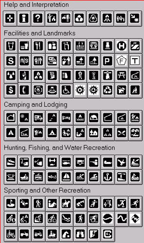
The New York Times has an interesting article on the development of the new Clearview font that is likely to replace the old Highway Gothic font in US highway signage in the future. If you want to use the the Clearview font for map labels or signage, it’s available from this website, at a heavy cost ($795 for 1-5 workstations). But there’s an adaptation of the fonts available in TrueType format at this website that’s free for personal, hobby, educational or non-commercial uses (read the license on the website, and in the zip file, for the full details). Just unzip the fonts into the appropriate Fonts folder for your OS (for Windows, that’s the Windows\Fonts folder), and they should be available as a font selection in your application. Also included are versions of the old Highway Gothic font, as well as English and German highway signage fonts. And there’s a link to the Minnesota DNR’s TrueType font with recreational symbols.

recsymbols