

There’s a bit of cognitive dissonance in posting about free toolsets for a program that costs well over $1000 if you buy it new. Still, I’m guessing that a fair number of visitors to this site use ArcGIS, and may not be familiar with some of these. There are also free tools available from the ESRI support site as well.
Author Archive for Leszek Pawlowicz Page 67 of 79
I’m posting about the University of Maryland’s Global Land Cover Facility, a massive archive (13 terabytes and growing) of various kinds of satellite imagery and derived data, even though I suspect many readers of this blog are already familiar with it. Most of the data is freely downloadable, accessible through a browser-based interface, and georeferenced for use in GIS and satellite image analysis software. Images are typically at moderate resolution (15-250 meters per pixel); free access to Ikonos high-resolution imagery is available only to NASA-affiliated researchers. For multi-wavelength data, you can usually download separate images for every spectral band as well as composite images.
Direct satellite imagery includes:
ASTER (Advanced Spaceborne Thermal Emission and Reflection Radiometer))
- L1B Imagery (three different sets of IR imagery at various resolutions, covering the spectral range of 0.52-11.65 microns)
Landsat (Multiple bands, visible and IR, at 15-60 meter resolution from all Landsat missions)
- GeoCover
- Landsat ETM+
- Landsat MSS
- Landsat TM
MODIS (Moderate Resolution Imaging Spectroradiometer) (7 bands covering the visible and near-infrared ranges)
- 32-day Composites
- 16-day Composite
There are also many datasets derived from the multi-spectral satellite imagery and data from the Advanced Very High Resolution Radiometer (AVHRR).
Many of Garmin’s mid-level handheld GPS units support auto-routing: automatic determination of the shortest distance or fastest time route to a destination, with turn-by-turn instructions (check your owner’s manual to see if your unit supports auto-routing). However, it was necessary to buy the City Navigator map disks to do turn-by-turn routing on-the-fly on your GPS. The cheaper MetroGuide map disks were able to do this in Version 4, but starting in MetroGuide Version 5 you could only do MetroGuide routing in the MapSource or nRoute programs on your PC, not on-the-fly on your GPS. MetroGuide is not only cheaper than City Navigator, it’s also unlocked, meaning you can use it on multiple GPS units; City Navigator is locked for use on a single GPS unit. But there’s a free piece of software that enables auto-routing on your GPS unit using MetroGuide maps.
Continue reading ‘Free Garmin GPS Unit Auto-Routing With MetroGuide Maps + Free European Basemap’
After being unofficially open for several weeks, Matt Fox’s Google Earth Library is now fully open and operational. Many useful and interesting sets of placemarks and tiled overlays, covering topo maps, aerial photos, aviation, weather, geology, solar system objects, global warming, etc., with more added every day. Add this one to your bookmarks/RSS feeds.
Zonum Solutions, the source of such utilities as shp2kml, kml2shp, kml2x, and DigiPoint, has just released another good one. MapTool not only lets you determine the coordinates and elevation of any point in Google Maps, but also lets you measure both distances and area directly in Google Maps as well.
Continue reading ‘Measuring Elevation, Distance And Area In Google Maps’
There’s one last feature in 3DEM I want to talk about: the ability to create animated fly-bys over terrain, with or without an image overlay. Doing a comparable animation with Google Earth requires either the expensive Pro version, or a copy of FRAPS for $37. While 3DEM’s animations aren’t as fancy as the ones you can get with Google Earth, they’re pretty good.
I’ve posted before about absolute positional accuracy issues in Google Earth. The Google Earth coordinates corresponding to a feature on the earth can be off from the true coordinates of the feature, about 30 feet in my neck of the woods. With the new Google Maps “My Maps” feature, I was curious as to whether you get any improvement in positional accuracy using Google Maps to create KML files for a point, rather than using Google Earth directly.
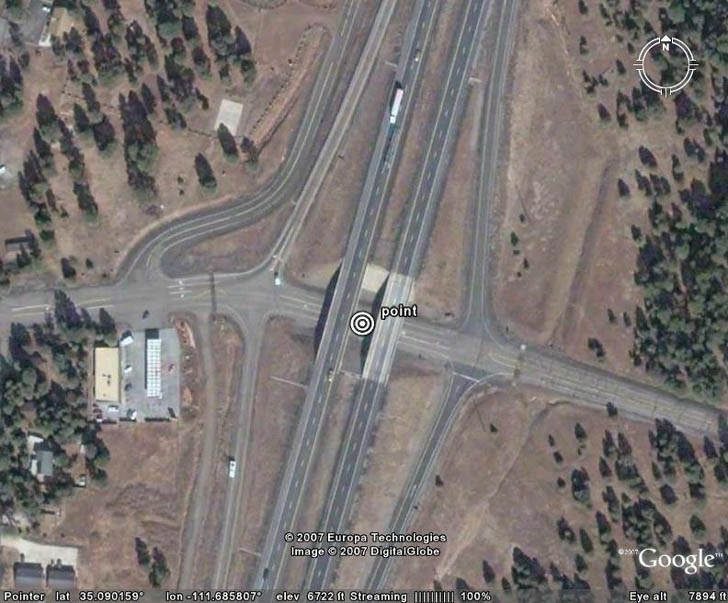
First, I created a point in Google Earth at a highway intersection:
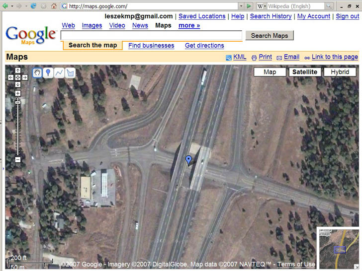
Next, I created a point at the same location in Google Maps “My Maps”:
Exporting the Google Maps point as a KML file, bringing it in to Google Earth, enlarging the view, and measuring the difference between the two:
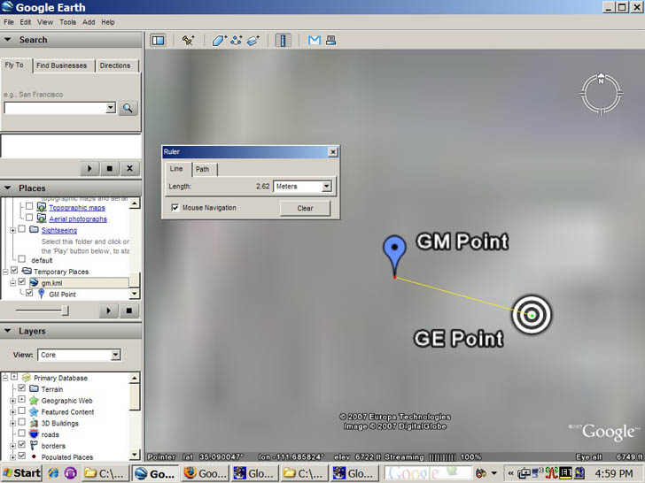
GM point is from Google Maps, GE Point from Google Earth. There’s a slight differential in the two, about 2.5 meters, but that’s almost certainly due to my inability to position the points exactly in the right location in both images, i.e. I’m a klutz. So coordinates match up reasonably well between Google Earth and Google Maps.
But if I plot these points on top of a georeferenced USGS aerial photo:
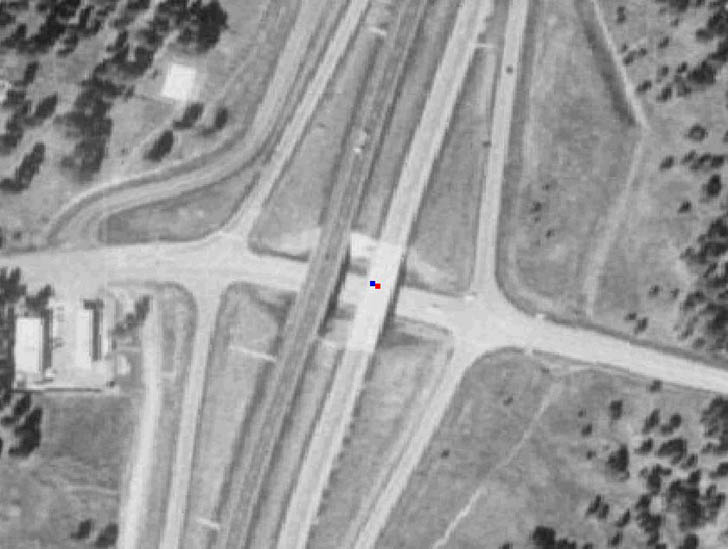
with blue being the Google Maps point, and red the Google Earth point, you can see they’re displaced from the actual position by about 10 meters, or a bit more than 30 feet. That’s comparable in size and direction to what I saw in my previous post on Google Earth accuracy. So you’ll get consistency if you export data from Google Maps “My Maps” to Google Earth, but the coordinates you get in the Google Maps KML file can still be off from the true values. It wouldn’t surprise me if the magnitude and the direction of the shift varied from place to place; if you’re hoping to use either Google Maps or Google Earth for determining positions with high accuracy, you should definitely do a ground check first to see what degree of coordinate shift there may be in your area.
Note: If you have info about the Google Earth or Google Maps coordinate shift for your area, please post it in the comments section below (location and size of shift).
The Map Room posts on GeoGratis, the Canadian Government’s new web gateway for free geographic data, both raster (topo maps, satellite images, etc.) and vector (hypsographic, political, etc.). No DEM (digital elevation model here), but you can get 90-meter data for Canada from the Geobase website or the USGS Seamless Server.