blankblank blank


Author Archive for Leszek Pawlowicz Page 14 of 79


Sample Applications With Code For The Google Earth Plugin

Stumbled across this page with a number of interesting applications using the Google Earth Plug-In, that might prove useful for someone trying to learn what it can do. Click on a directory name, then click on the .html to start up the application; right-click on a file to save the code to your computer for examination/modification. Among the apps are:

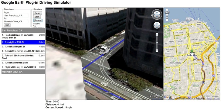
The Google Earth Driving Simulator: Enter a start and finish destination, and a miniature car will drive that route in the Google Earth Plug-in, and also in an adjacent Google Maps interface (Firefox only, apparently):

3-7-2009-9.51.57 PM

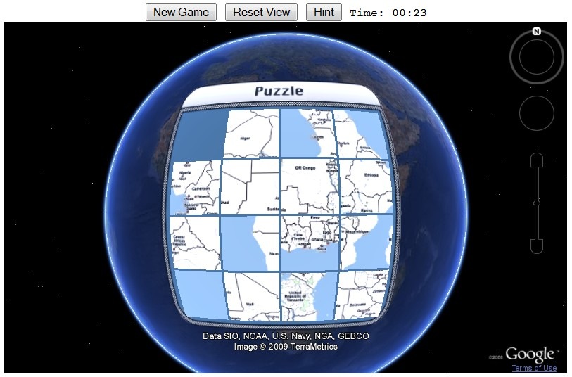
Sliding Tiles Puzzle: Click on tiles of Africa to move them to the empty square, ultimately putting them in the right order to re-assemble the continent (a version of the old Sam Loyd 15 tile puzzle):

3-7-2009-9.53.40 PM

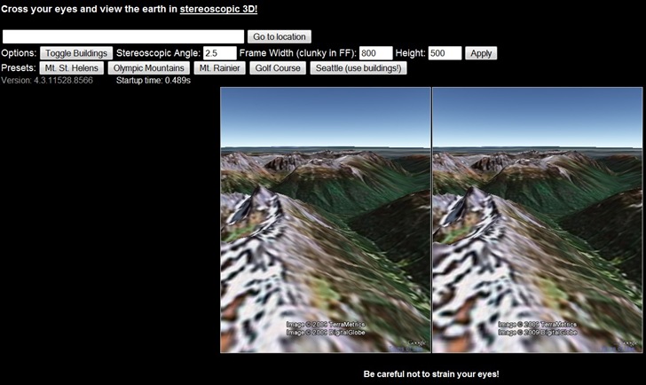
Stereo: Open two views of the same area, but at slightly different angles; if you can cross your eyes right, you’ll get a stereo effect. My eyes are a bit too old to get it to work :(.

3-7-2009-9.59.04 PM


Free And Open Source Windows GIS Software Installation With OSGeo4W

The OSGeo4W project is an automated installer for a variety of Free and Open Source Software GIS applications for Windows, including command-line, desktop and web apps. While some of the programs in this installer are also available in stand-alone installers (e.g. uDig and OpenEV), others can currently only be installed using the OSGeo4W installer (e.g. Quantum GIS (qGIS) v. 1, and the native Windows version of GRASS (6.4.0RC3-2)). You have two install options, Express and Advanced. Express just gives you a short checklist of installable applications:
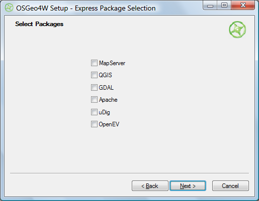
OSGeo4W Express install

Choose the ones you want, and OSGeo4W takes care of downloading, unzipping and installing the programs, including all required dependencies. Desktop apps will be found in the Start Menu under Start => Programs => OSGeo4W; there will also be a “OSGeo4W Shell” icon that starts up a command window for running command line programs. You’ll also be given the option to put icons on the desktop.

Selecting Advanced installation takes you through a set of configuration screens, then the one you need to use to select the programs to install:
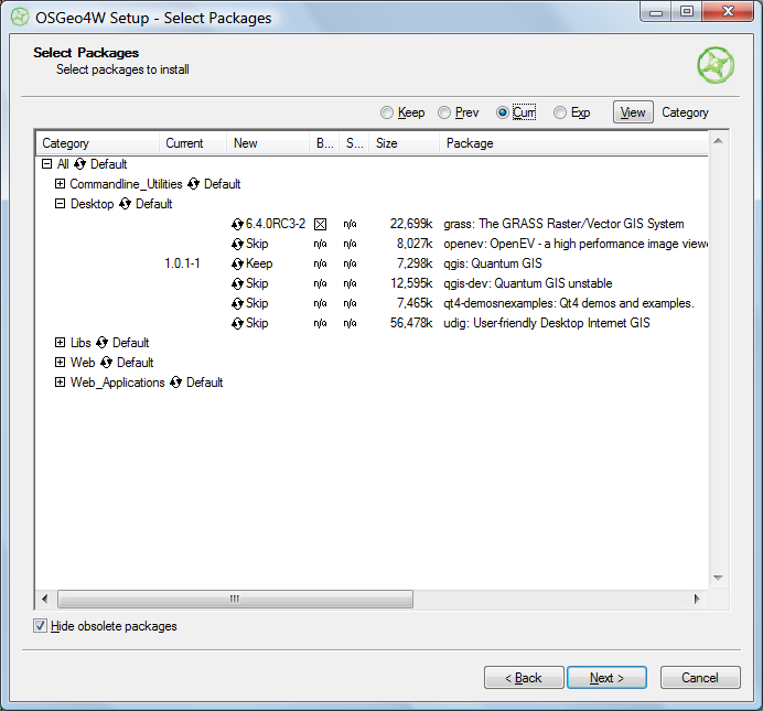
OSGeo4W advanced install

Clicking on the circular arrow icon will take you through available options for that program:

  • Skip – No install
  • Keep – Keeps the currently installed version of that program. In the screen above, I already have Quantum GIS 1.0.1-1 installed, and would probably want to keep it.
  • Uninstall – Uninstalls a currently installed program
  • Reinstall – Reinstalls the same version of the program, useful if it’s gotten corrupted
  • Version numbers – Installs that version of the program. In the example above, the 6.4.0RC3-2 version of GRASS would be installed. I could also select a different version of Quantum GIS to install over the current version.

“Hide obsolete packages” presumably does what it says, but I was unable to find an example of an obsolete package being hidden or unhidden by checking/unchecking the box.

Once you’ve selected your desired packages, clicking Next starts up the same install process as in Express.

I can certainly see how this installer has its advantages, but for now think I still prefer stand-alone installers for individual programs; they give you more control over which program options to install, and which directory to put them in.  Also, if you use a stand-alone installer, you’ll typically be downloading it from the app’s home page, and will have already found out what it is and what it does from there.  The OSGeo4W has no such info in it, and I think the installer would benefit from having some kind of descriptions of the available software built into it (the current Package Listing page has no such information, so you’ll have to go to every program’s home page to find out more about it). But advanced users may well prefer OSGeo4W’s approach.

It would also be helpful if the OSGeo4W installer could also make a copy of itself in a program directory and create a desktop icon for itself; as is, you have to manually keep track of where the program is if you want to run it again in the future for additional installs or program updates..


Animated Cartograms Of World & USA Demographic And Economic Data

Mapping Worlds has created two sites for the USA and the world with animated cartograms, maps where the value of a parameter is used to adjust the drawn size of a geographic area. Here’s an animated cartogram showing military spending for world countries; click on the clockwise circular arrow on the map to have the countries resized based on their military expenditures:


Click on the Resize button (the counter-clockwise circular arrow at the upper left) to reset the countries to their original size. Repeat at will.

Data can be very timely; here’s a USA cartogram showing stimulus bill jobs by state:

Over 140 datasets are currently available with demographic, economic, trade, environmental, etc. data; you can also submit your own datasets for inclusion. Direct links are immediately available for every cartogram page, but you can also get images and embeddable code (like the examples above) emailed to you if you agree to Mapping Worlds’ Terms Of Use.


Online KML To Shapefile Converter

Just got an email from Zonums Software that, after a prolonged hiatus, they’ve resumed development of free stand-alone and web-based geographic tools. I’ve posted previously on their stand-alone KML to shapefile converter, but a glance through that post’s comments will reveal that it has some serious bugs in it. While those are still being fixed, Zonums has released an online KML to shapefile converter:

Continue reading ‘Online KML To Shapefile Converter’


Web Application For Querying NGS Survey Marker Locations And Displaying Them In Google Earth

Not too long ago, I posted about DS World, a Windows app that lets you query a database of National Geodetic Survey markers, and returns a KML file to display them in Google Earth (note: earlier versions of DS World may have problems with Google Earth 5, but the newest one works fine). In comments, the survey firm of Metzger and Willard noted that they’ve created a web app called NGS Control Stations (NGSCS) Radial Search that performs a similar function. Despite the name, it allows search by three different areal selection methods:

Continue reading ‘Web Application For Querying NGS Survey Marker Locations And Displaying Them In Google Earth’


Lots More 1:24K-Equivalent Garmin Topo Maps Now Available

Since my last update on free 1:24K-equivalent topo maps for Garmin GPS units from GPSFileDepot, there’s been a huge explosion in the number of states covered:

  • Southeast US: Covering all of Alabama, Florida, Georgia, Mississippi, North Carolina, South Carolina, and Tennessee; parts of Arkansas, Kentucky, Louisiana, Missouri, and Virginia
  • South-Central US: All of New Mexico, Oklahoma, and Texas; parts of Arkansas, Louisiana, and Missouri
  • Southwest US: Covering all of Arizona, parts of CA, UT, and NV
  • Illinois: The entire state
  • New England: A combination of mapsets previously available separately for MA, ME, VT, NH
  • Montana Landowner Topo: The whole state, with special colors identifying landowners
  • New Jersey: Entire state
  • New York: Entire state
  • Ohio: Entire state
  • Washington: Entire state
  • West Virginia: Entire state

Windows installers available for all, Mac for many. Part of the reason for this flurry of activity may be that Dan Bloomberg, webmaster for the site and creator of most of the older maps, has released a new tool called Topo Process that simplifies the process of obtaining and processing the data necessary to create these topo maps. While the official Garmin 1:24K topo maps have more features, like elevation profiles, routing, and shading in supported units, much more of the US is covered by these free maps than is currently available from Garmin. And you can’t beat the price.

In addition to the topo maps, a browse through the Custom Maps directory will bring up lots of other specialty maps and data, like trails, POIs, and even raster maps for a few areas like Joshua Tree National Park.


MapChannels Updates To Version 3

MapChannels (covered several times before on this blog) has announced version 3 of their embeddable Google Maps data tools. New features include:

• Restructuring of the design process
• User-definable dictionaries to present maps in any language
• Support for spreadsheet data in either tab-delimited format or from Google Spreadsheets
• Support for GeoRSS feeds using the Google Feeds API
• Marker clustering to display large numbers of markers on a map
• Google Street View
• Microsoft Virtual Earth

I’ve played with a bit, and it is easier to use than Version 2 (which is still available). Especially nice is the Google Spreadsheet feature; while Google had a “wizard” that walked you through one way of doing this before, the MapChannels method is far easier to use, and the ability to add GeoRSS feeds and other data makes it more powerful.


GIS For Dummies Just Published

You know GIS has hit the big time when it gets its own “Dummies” book:


The author, Michael DeMers, is a professor of geography at New Mexico State University, and the author of the textbook Fundamentals Of Geographical Information Systems:


I ordered a copy of GIS For Dummies today, and plan to have a review up on this blog soon.