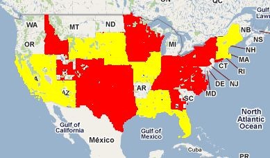
The USGS is well on its way to having updated all its 1:24,000 scale topographic maps (the classic 7.5-minute series) to digital format. As of today, the coverage map looks like this:

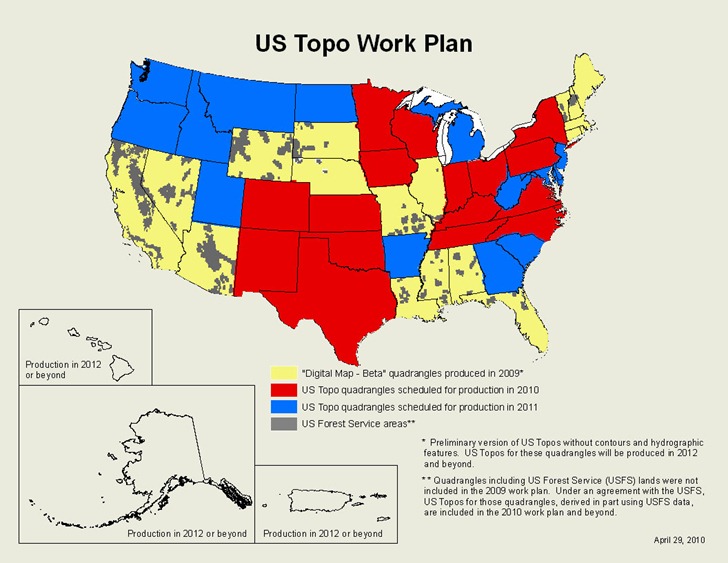
Areas covered in red are full topographic maps in in digital format; areas in yellow are “Digital Maps”, which have transportation features, boundaries, geographic names and aerial imagery, but no topographic contours or hydrographic features. According to the current schedule, most of the US will have either full topos or “Digital Maps” by the end of 2011, with Digital Maps scheduled for upgrade to full topographic maps starting in 2012:

On one hand, the maps are very nice – they have multiple data layers, each with a separate kind of data, whose view can be turned on and off. Most data layers are vector, which means no more scaling/pixelization issues. On the other hand, the maps are currently only available in GeoPDF format, which limits their usability, particularly in GIS-related software. This was a conscious decision by the USGS:
The US Topo was not intended to be a GIS product. It was designed to serve users who need medium-scale topographic and orthoimage maps, but who are not GIS users.
US Topos are derived from GIS data. Almost all these data are from USGS and other government sources, and most are available for free through web services or file download sites. The US Topo represents a repackaging of these data, not new data creation. The primary design objective was to provide these data in a convenient and familiar form to people who need maps but who are not professional cartographers. The traditional 7.5-minute quadrangle layout and PDF format were selected as the best way to accomplish this objective; the GeoPDF extensions were adopted because they added some cartographic value at no cost to the end user.
Which is fine, but it still leaves some serious drawbacks with the format:
– As mentioned, not supported by most GIS programs, and I know that USGS topos are often used as the background base layer for maps. The USGS FAQ page mentions ArcGIS ($1500) and GlobalMapper ($350) as two options for converting GeoPDFs to GeoTiffs, but the price puts those out of reach of many.
– Printing the maps is a pain if you don’t have a large-format print, especially if you’re only interested in printing a subsection. The USGS Quickstart guide describes how to do it with Adobe Reader, and it’s not exactly a one-step process; what’s more, it’s virtually impossible to print to scale using their recommended procedure.
– Feature contrast isn’t always optimal, especially if you have the aerial imagery background turned on, and there’s no way to adjust that on a GeoPDF (unlike a GeoTiff).
– Newer Garmin GPS units support the Custom Map format, which lets you view custom raster imagery on the display screen; however, GeoPDFs aren’t in a raster imagery format that can be converted to this Custom Map format.
I’ve written a Garmin Custom Map utility called G-Raster, which converts GeoTiffs and other raster imagery types (KMZ overlays, MRSID, ECW, OziExplorer, graphics with worldfiles, BSB) into a Garmin-compatible Gustom Map format. Most features are free, but a few are unlocked with a $5 registration fee. The latest version (4.0) adds a new feature: a GeoPDF Tool GUI which can convert many (albeit not all) GeoPDFs into GeoTiff format. Interface is pretty bareboned – just specify the desired DPI of the final image, choose the GeoPDF filename, and a GeoTiff with the same name (but with “_gt” appended to the filename) will be created in the same directory as the original file:

Also generated with the “listgeo” utility will be a “.gtf” file with that GeoTiff’s metadata; this file can be used to re-embed the metadata into a GeoTiff file that has been enhanced by a graphics editor that does not preserve geographic metadata.
For example
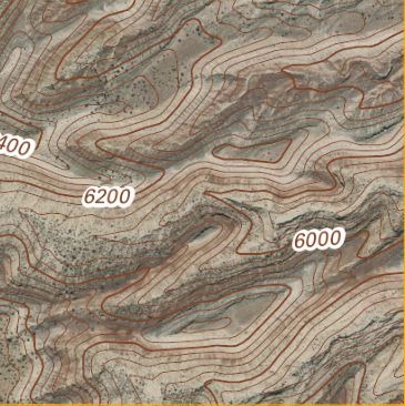
1. I converted the Fruita, UT next-generation PDF into a GeoTiff:

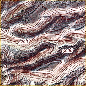
2. Garmin GPS units can have contrast issues when used in sunlight. So I loaded the GeoTiff into Photoshop to enhance contrast, and saved it under a different name; this process improved visibility, but also stripped out the geo metadata:

3. I embedded the “.gtf” metadata back into the enhanced Tiff file using another tool included with G-Raster, and then converted it into a Garmin Custom Map (screenshot from my Garmin 62s):

Other features and limitations of the tool:
– The unregistered version limits you to a maximum size of 2000 x 2000 pixels; images larger than these limits will be cropped. Registering the program removes these limitations. This way, you can test the tool to make sure it works for you.
– Works fine with all next-generation USGS topo maps and Digital Maps in GeoPDF, as well as older maps in the UTM coordinate format. Some older GeoPDF topo maps that are in the Lambert Conformal Conic projection don’t reproject correctly; the GeoPDF Tool will identify those problematic files, to let you know they may not be correct.
– The USGS 1:24K input option in G-Raster will crop the collar of these next-gen topographic maps; another new option in G-Raster will let you export this collared topographic map in GeoTiff format (geographic projection, WGS84).
– Not all datums are currently supported; unrecognized datums are assumed to be WGS84. This is a good assumption for newer maps, a poor assumption for older ones. I do know that it does support NAD27 and NAD83 datums.
– There’s currently no way to turn off data layers in the GeoPDF when exporting it to GeoTiff format; all data layers are included. The help file includes a mildly-convoluted work-around hack that will let you create GeoPDFs with data layers turned off.
– Once in GeoTiff format, the next-gen topo maps can be opened in any compatible GIS program or graphics editor; you can then enhance/crop them, and easily print a smaller subsection. You can also print them to scale, or use poster printing to create maps larger than your printer’s maximum paper size.
More information about G-Raster, and a link where you can download it, can be found at the G-Raster web page.