A previous post dealt with printing maps larger than a printer’s biggest paper size (Printing Large Maps On A Small Printer). The solution was to split the map image into smaller tiles to be printed separately, to be cut and taped together to form a larger whole. But what if you want to print such a larger map at a specific scale, like 1:24,000? Tiling and printing a map to scale using the options described in that post would be a major pain – you’d have to calculate the correct image size, and then resize the pixel dimensions of the image to get it to print that size. You might even have to add additional blank space to the map edges to get everything to work out.
The program MicroDEM has the ability to automatically tile and size a map image to a specified map scale and paper size, and then print it out on multiple pages for you. Open a georeferenced image in MicroDEM (like a GeoTiff, or a standard graphic format with a world file), and then zoom the image using the 1:1 toolbar button at the top of the map window:
![]()
If you don’t zoom to the full 1:1 pixel dimensions, the image will be printed at the original screen scale, which will make the printed version highly pixelated. Next, click on the Print toolbar button:

and select “Print preview & print to scale” from the drop-down menu. You’ll get a window like the following:
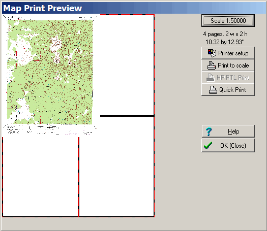
In the upper right-hand corner, the current map scale setting is shown, along with the number of sheets of paper that will be required to print the map at the current paper size setting, and the map size in inches printed at the specified scale. At the left, the map image will be displayed as it will be printed on the sheets of paper represented by the rectangles outlined in red.
To change the scale, click on the button that displays the scale, and enter the desired number. To change the paper size or printer settings, click on “Printer setup” and make the desired adjustments. In particular, try experimenting with portrait vs. landscape orientation to see if you can fit a map on fewer sheets of paper.
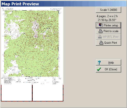
So if I change the scale of the original map above to 1:24,000, and set the paper size to 11″ x 17″, the window will now look like this:
Click on the “Print to scale” button, and MicroDEM will slice up the map and print it on the specified number of sheets. It can take a while (scratch that, it can take a loooong while) to process the data and print it out, especially for large images; a fast processor and a large amount of memory will help with that. The options described in the post Printing Large Maps On A Small Printer might not be able to print to scale easily, but they do print the tiles a lot faster than MicroDEM does. When the tiles have been printed, cut the blank edges off the appropriate ends of the tiled map pages, then tape them together to create the full map print. Since there’s no image overlap, you’ll have to be careful when trimming them not to remove parts of the printed image, otherwise they won’t fit together exactly.
You can also use this approach along with PDFCreator to generate PDF files of scaled map prints, to be sent to a computer or print service capable of handling larger paper sizes directly.