blankblank blank


Archive for March, 2010 Page 2 of 2


OA Digital Version Of gvSIG 1.9 Is Out

Back in November, I posted about the release of the gvSIG 1.9, a free multi-platform Java-based GIS program. Oxford Archaeology Digital, which created their own improved installer for the previous 1.1 version of gvSIG, has just released the second beta of a similar improved installer for version 1.9. Differences from the official baseline 1.9 installer include (from the website):

  • Completely new installer frontend.
  • Bundled with many extensions.
  • Java Runtime Environment version 1.6r17 (Linux and Windows versions only).
  • Complete and consistent English (GB, US) GUI translation.
  • Heavily reworked and improved menu structure, keyboard shortcuts and layer context menus.
  • Additional documentation and sample data.
  • Better integration into all supported operating systems.
  • Both Windows and Linux versions are now available; a Mac version is listed as coming soon (the earlier version is still available with a Mac installer). I had no problems installing it on Windows 7, but some people apparently have; the website includes a workaround fix if you run into those issues. Screenshot showing sample data:
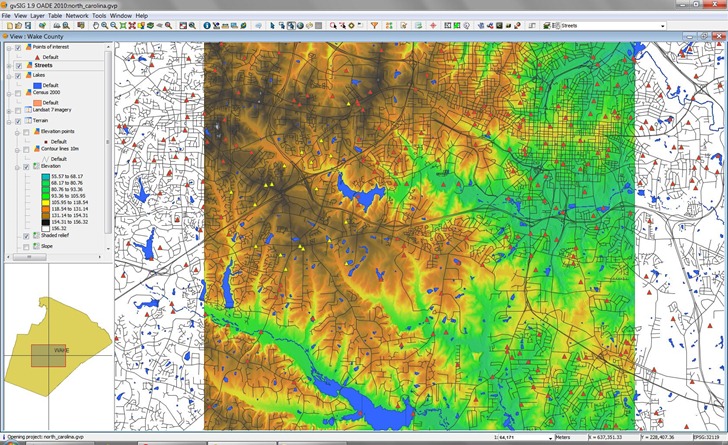
    gvsig1.9

    Having played around with it a bit, I have a few initial impressions.

    The feature set is one of the strongest of any free GIS program currently available, especially if you choose to install all the optional plug-ins (highly recommended, as is the sample dataset option). Many of these come from the Sextante plug-in, which adds a staggering amount of functionality for vector manipulation/analysis, network/topology, geostatistics, aerial/satellite imagery processing, rasterization, vectorization, georeferencing, hydrology, pattern analysis, etc. – well over 200 new functions. Combine that with the standard gvSIG feature set plus the new version 1.9 features, and few free GIS programs compare. You’d pay thousands of dollars to get much of this functionality in commercial GIS software; for free, downloading and installing this is a no-brainer.

    But there are some issues with it. Frankly, it’s a bit slower than other GIS programs in loading, displaying and redrawing data, and this is with my reasonably fast system. Somewhat more annoying is that it isn’t always fully responsive. For example, clicking on layers to select them can take repeated attempts to be successful. Some of the new functionality doesn’t seem to be working yet; for example, several attempts to generate vegetation indices (e.g. NDVI) from the sample dataset using the Sextante functions were unsuccessful – I got a blank image. The same functionality in SAGA (from which many of the Sextante functions were derived) worked fine. Documentation for the Sextante functions isn’t adequate to figure out what I might be doing wrong; for that matter, documentation for the extensive set of new functions in the gvSIG base program are currently only available in Spanish (there’s an English PDF manual for the previous version included in this distribution). So expect to spend some time figuring out how do do things.

    These are minor quibbles, though, and I expect that all these teething issues will be fixed before long. In particular, I look forward to English documentation of the new features. Even in its current form, I think I’ll be using gvSIG a lot, and I look forward to seeing how it develops in the future. Many thanks to both the gvSIG developers and OA Digital.

    Slice And Dice Data With Microsoft Pivot

    Microsoft Live Labs’ beta Pivot software lets you slice, dice, analyze and examine data, including geographic data, with a unique, animated visual interface. You can’t currently use your own data, but several sample datasets have geographic attributes, including:

    • National Parks
    • World Leaders
    • Endangered Species
    • Sports Figures
    • Kiva Loans

    Here’s a screenshot of Kiva loans grouped by alphabetical country groups:
    Continue reading ‘Slice And Dice Data With Microsoft Pivot’


    Overlay OpenStreetMap Data Transparently On Google/Yahoo Maps

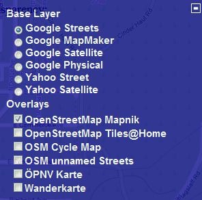
    The transparent com site lets you select a base map layer from Google or Yahoo, and then overlay an OpenStreetMap (OSM) data layer on top with user-definable transparency. Zoom in to your area of interest, pick the base and overlay layers by clicking on the “+” sign in the upper right:

    overlayoptions

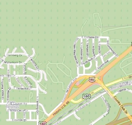
    And see the base layer and OSM data together:

    overlaymap

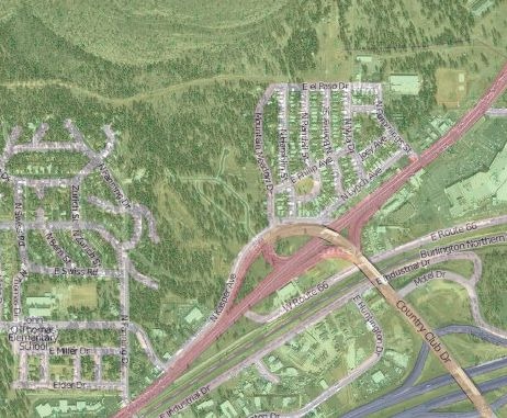
    In this area, there are a fair number of roads that show up in Google Maps, but don’t show up in the OSM database; bringing up the Google Satellite view confirms that these roads actually exist:

    sat

    A cursory check shows that the Google Maps data is more accurate and up-to-date than the OSM data for this area. You can’t use the Google Maps data to correct the OSM maps, but this can be useful in showing you what areas need better mapping data. I’ll have a post soon on OSM editors.

    Via GPS Tracklog.


    Two More DEM Format Converters

    Hoisted from the comments from my post on creating ESRI ArcGrid DEM files for use with Terrain Bender, two more options for converting other DEM formats to ESRI ArcGrid, plus many other formats as well.

    LandSerf: A multi-platform (Windows, Mac and LInux) terrain visualization and analysis program, LandSerf can also import/export DEMs in a number of formats (.bil, .flt, .grd, .asc, .dem, .bin, .hgt, .ter, .bt); VRML (.wrl) is an additional export format.

    VTBuilder: Windows only, VTBuilder lets you import/merge/resample DEM data in any GDAL-supported elevation format (and several additional ones like MicroDEM DEM files), and export the data in the following formats:

    • ArcInfo ASCII Grid (*.asc)
    • GeoTIFF
    • TerraGen (*.ter)
    • STM
    • MSI Planet
    • VRML ElevationGrid (*.wrl)
    • RAW/INF for MSFS
    • ChunkLOD (.chu)
    • 3TX
    • VTP (*.bt)

    VTBuilder was primarily designed for use in putting together data for the Virtual Terrain Project, an open-source 3D landscape visualization program. The VTP site contains a wealth of links to software, data, and general information about terrain visualization, and is well worth a look.


    Create A Horizonless Projection View With Terrain Bender

    One more brief post on Terrain Bender, a program that lets you create varying-perspective terrain views, analogous to what you get looking from an airplane window: straight-down for nearby terrain, an oblique view for terrain further away:

    Continue reading ‘Create A Horizonless Projection View With Terrain Bender’