Note: you should read this post first for general info about how to use automated Google Earth caching programs.
First up is the oldest Google Earth caching program I could find, GECacheBldr; download it from any of the program links in this message board thread. No install program, but by copying it into its own directory, you’ll be able to more easily find the KML file it generates during operation, called “Cashbild,kml”.
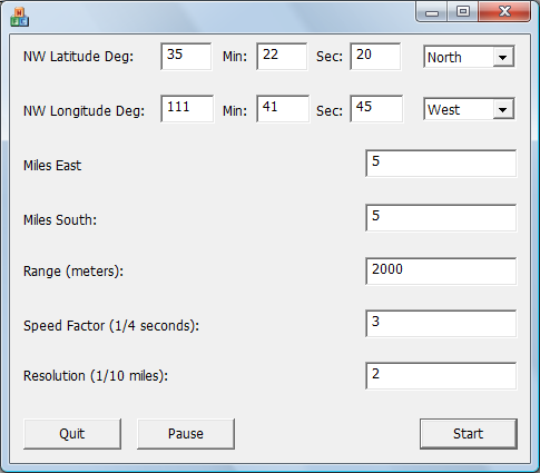
Running the program brings up a simple screen:

You start by entering the latitude/longitude coordinates of the NW corner of the area you’re interested in, in degrees-minutes-seconds, also setting North/South and East/West for latitude and longitude. You can set Google Earth to display in these units using the Tools => Options menu item, 3D View tab. Then set the distance east and south of this corner location you want to cache the data for in miles. Range (in meters) sets the altitude above the ground, which in turn determines the resolution of the cached imagery – a lower altitude means higher resolution imagery (and a larger cache file).
Speed factor refers to the time between successive KML file position updates, with higher numbers meaning slower updates; the author recommends 3 to start with, but I would start with 40 (a 10 second update time), and then adjust that up or down as needed. Resolution sets the spacing between successive Google Earth views, when the caching takes place. Follow the guidelines in this post for setting the resolution based on either the Range or your Google Earth view. Once you’ve set the parameters for a caching run, you can’t change them without quitting and starting all over again.
The first time you run the program, click the Start button, then immediately click the Pause button. This generates a file called “CashBild.kml” in the same directory as the executable; this is the KML file that the program regularly updates with new positions. You’ll need to create a Network Link to this file (see this post for details). Once this “CashBild.kml” file is created, you won’t have to do Start/Pause again; just make sure the Network Link to the file is created and active in Google Earth.
When the Google Earth Network link is ready, click on the Start button again in GECacheBldr, and watch Google Earth for a brief time. You’ll see Google Earth move automatically from one to view to another. If the parameters are set correctly, then the imagery will have time to download completely, and will look sharp; if not, it will stay blurry, and you’ll need to try again with a different set of parameters. It may take a few trials, but eventually you should come up with a set of parameters for a particular altitude that gives good results. When the view stops changing in Google Earth, the caching is complete, and you can now use the disk cache data directly, or copy it to another directory for use at another time as described in this post. Don’t forget to delete or de-activate that network link to “Cashbild.kml”, or every time you open Google Earth afterwards it will fly to that last location and view.
The program does the job, and has a nice, simple stripped-down interface. I’d prefer it if you could set the actual latitude/longitude bounds instead of the NW corner and then the distances; the mix of units (DMS for coordinates, miles for distance, meters for range, 1/4 seconds for update speed, and 1/10 mile for position spacing) is a bit confusing as well. The program is no longer being updated, and the author will provide the source code upon request.