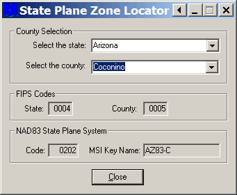
The State Plane Coordinate System (SPCS) is a projected coordinate system that achieves greater accuracy than UTM by dividing states up into sub-zones based on county, and then uses a local projection in that sub-zone (typically Transverse Mercator for zones that are oriented more north-south, and Lambert Conformal Conic for those that run more east-west). Keeping track of which county goes with which zone for every state can be a pain. The State Plane Zone Locator is a free utility that makes looking up the state plane system for any county easy. Oddly enough, the program installation doesn’t put any shortcuts into the Start Menu or on the Desktop, but the default install directory for the program is “C:\Program Files\MentorSoftwareCO\CountyLookup\”, and the executable is “CountyLookup.exe”‘. Run the program, and use the drop-down selections to choose the state and county you’re interested in:

The State Plane system ID info (NAD83 only) will show up at the bottom, in this example AZ83-C (AZ Central, NAD83). You also get the state and county Federal Information Processing Standards (FIPS) codes.
I’m dealing with the issue of needing to convert coordinates from UTM to SPCS from a command line script running on a Unix platform. I’ve looked in to writing my own code for this or leveraging from someone elses code but there seems to be no resources for this available and the task of writing this myself seems daunting and time consuming. Do you know of any example source code or resources that might help me?
You might look at two options:
GeoTrans, from NIMA, offers a coordinate converter that runs in Unix, and the source code is available:
https://freegeographytools.com/2007/coordinate-converters-ii-worldwide-coordinate-conversion
And, of course, there’s ogr, an open-source relative of GDAL:
http://gdal.org/ogr/
That’s all I’ve got; hope it helps.