Garmin handheld GPS units use vector graphics to display imagery, so it’s generally been considered impossible to view raster imagery on them, like USGS topo maps or aerial photographs. But I’ve figured out a way, and created a program that lets you convert free USGS topo maps downloaded from the Seamless Server, black-and-white DOQQs, color satellite imagery, any georeferenced raster imagery, to a Garmin-compatible format: Moagu – the Mother Of All GPS Utilities. Rich Owings has the first review at GPS Tracklog (he likes it!).
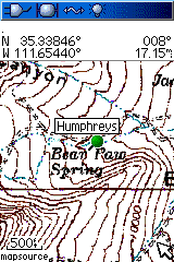
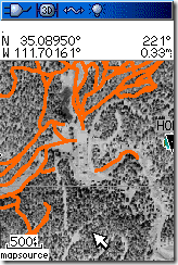
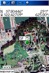
Here’s a few screenshots from my Garmin 60Cx:
 |
 |
 |
You can download a demo version at the website. Introductory price is $19.95.
It´s great, i just downloaded and tested and put the maps in a ique 3600 but is a shame does not work in all garmin units.
Really good work anyway.
Will this work with geologic maps?
This will work with any map you can put into a digital graphic format, and then “georeference”, i.e. assign geographical coordinates to every pixel location. I describe some free options in the help file, but you might also look at yesterday’s post, which describes a method to do that online.
This looks very cool Leszek!
I downloaded the Demo. But no matter what I do the program reports:
“This Worldfile is not in valid…..”
I tried maps in Bagdhad and Danmark. I reprojected the files using Global Mapper and the Utility in Moagu.
What did I miss?
I’m swapping emails with Thomas right now to track down the problem, but I believe it’s because Denmark uses “,” where the US uses “.” as the decimal point. If this is true, it will be fixed.
Edit: Yup, that was the problem. It’s now fixed.
Raul,
So you’re saying the maps work in an iQue 3600? Wow, I would not have expected that.
No I´m sorry, for my english grammar, what I want to say is I put the map but not work, only points with a tag “creted with cgpsmapp…….”.
So is good work but DON´T work in a ique
I guess your app is based on the same idea as http://mapwel.biz/
How do they compare? (Apart from the price :)
No – Moagu and MapWel use entirely different approaches. MapWel converts the image data from raster to vector, while Moagu uses the original raster data to generate its maps. Note: Moagu now offers a front-end to the free utility BMaP2MP, which uses the same vectorization approach as MapWel. There are advantages and disadvantages to both approaches:
– MapWel has a maximum color count of 16 in the current version, and a technical maximum of 60 colors (which they would implement if people wanted). Moagu can create images with up to 254 colors, the maximum allowed by the Garmin’s hardware. Edit: This is last week’s specs, including the “60 color” limit statement which came from one of MapWel’s programmers; as of this week, it now supports up to 86 colors.
– MapWel vectorizes the raster image, and requires you to prepare the image beforehand (with the limited color set) to improve the quality of that vectorization. Edit: Still true, but the latest version does do an automatic color conversion. Moagu can use the image unprepared, although you can improve the results with some image optimization.
– MapWel gets its best results with images that have a limited set of colors, and well-defined boundaries between colors. If you use those kind of images, you’ll probably get better results with MapWel than Moagu. Certainly faster displays. Edit: The latest version of MapWel is even faster for small areas at high zooms (500ft./120m), but the bigger the total area covered, the slower it gets.
– For general aerial imagery, especially color imagery with gradual color changes, Moagu’s results will usually be superior to MapWel’s. Any time you have an image with lots of small details in different colors, MapWel’s vectorization process is likely to lose some of that detail; Moagu won’t. For example, one Moagu user is converting aerial photos of coral reefs for use in a mapping project; subtle changes in water color with depth would be lost in MapWel, but are visible in Moagu. Edit: Still true, even with the greater color range of the new version. And display speeds for such imagery are comparable for both Moagu and MapWel.
– Display speeds on graphic maps (e.g. topographic maps, maps with sharp color distinctions, and limited color palettes) will be much faster for MapWel maps than Moagu; map size will be smaller, to. On aerial imagery with lots of detail, difference in display speed will likely be minimal.
– MapWel is more expensive ($45 for a version that works with a single unit, $90 for one with no limitations). But MapWel is also a full-featured Garmin vector map editor and creator, while Moagu only does one thing – converts raster imagery into Garmin maps.
Which is better? I’m not unbiased, but I’d say that for most raster imagery, Moagu will give better results than MapWel. Initial display speeds will probably be slower in Moagu maps than MapWel maps, but the display should be able to keep up with your position for walking speeds, and even bicycling speeds for some kinds of maps (maps with lots of white space in them). There are display update issues at driving speeds for maps from both programs. But if you’re primarily using maps with sharp color distinctions, and limited color palettes, MapWel might be a better choice, especially with its vector editing capability; if you want maps that cover large areas, Moagu will probably do a better job.
Here’s an article on using MapWel to make USGS topos:
http://travelbygps.com/articles/cartography.php
Leszek,
Thanks for that comparison, helped me to understand. I’m going to start with Moagu and then only use Mapwel if I’m dissatisfied.
I’m just getting into custom maps for my Garmin Legend HCx, and your site is a great one. But it seems like it’s all for Windows and not Macintosh. I run Mac OSX 10.4 and would love to be able to get .img
files and raster images into my GPS.
Are there any utilities for working with OSX? Or am I gonna have to do it all on a Win machine and then
transfer the results to Mac?
When it comes to creating maps for Garmins, it’s a Windows world; there’s no Mac programs I know of that will create .img files for Garmins. So yes, your only option for now (and for the foreseeable future) is to do it all on a Windows machine, then transfer the results to a Mac.