In a previous post, I covered DNRGarmin, the best solution out there for downloading data from Garmin GPS units and converting it to the GIS-friendly shapefile format. But what you do you do if you don’t have a Garmin, or you have a mix of Garmin and other brands and want to stick to a single process flow? It can be done, but it takes a bit more work than with DNRGarmin.
Continue reading ‘Exporting GPS Data To GIS II – Generic Solutions’
Geodetic-quality GPS units are usually able to output data directly into a GIS-friendly format like shapefiles, either with built-in software or with add-on packages like Trimble’s Terrasync or ESRI’s ArcPad. But what if you have a consumer-grade GPS unit without the ability to run this software (or you don’t feel like coughing up hundreds of dollars to buy a copy)? This post and the next one will cover some options for downloading data directly from a GPS and converting it to the GIS-friendly shapefile format. First up – an easy solution for Garmin GPS owners.
Continue reading ‘Exporting GPS Data To GIS I – Garmin GPS Units’
Now that I’ve written a whole slew of posts about how to download and upload data to and from Google Earth with a GPS, using several pieces of software and multiple steps, I’ve just found one piece of freeware that simplifies the process tremendously. *sigh*
Continue reading ‘GPS TrackMaker: A Better Solution For GPS Export/Import With Google Earth’
Now that I’ve run you in circles to import and export GPS data to and from Google Earth, I can tell you there’s another “freeware” software option that can simplify the process a bit – GPS Utility. But “freeware” is in quotes because while the program is labeled as “freeware”, the splash screen and documentation indicate that it’s “freeware” only for evaluation purposes (though that evaluation period is “unlimited”). The “freeware” version also limits you to 100 waypoints, 500 track points, and five routes. If you plan to use it on a regular basis, you are required to pay the $55 registration fee, which also expands its data import capacity to 65,000 waypoints and track points .
GPS Utility has a *lot* of features, too many to go into now. But the ones relevant to Google Earth import/export are:
- Downloads data from GPS units, and supports most models
- Saves data in either GPX or KML format, for importation into Google Earth
- Can open KML files created in Google Earth, and save them in GPX format for upload to a GPS unit in a different program
- Can also directly upload the KML file data into a GPS unit, bypassing the need to use a program like EasyGPS to upload the data
It’s a nice program, and worth trying out, both for the Google Earth functions and other capabilities. But if you plan to use it on a regular basis, or if you need to import more data points than allowed by the “freeware” version, you’ll have to pay the $55 registration fee.
The info page for Google Earth Plus says, quite explicitly:
“Does not support export of tracks or waypoints to a GPS”
So if you wanted to use the GPS interface capabilities of Google Earth Plus to plan a trip by entering point markers and paths that you can export into your GPS unit as waypoints and tracks, you’re out of luck ….. not! If your GPS unit supports the importation and display of waypoints and tracks, and most do, there’s a fairly simple way to convert data created in any version of Google Earth (including the free one) to a GPS-compatible format, and then send it to your GPS unit.
Continue reading ‘Exporting Data From Google Earth To A GPS Unit’
EasyGPS is simple and easy to use, and it’s my program of choice for downloading data from a GPS unit. But there’s an alternative to using EasyGPS in Windows: GPSBabel (freeware; open source; Windows, Mac and Linux). GPSBabel also comes with the ability to convert GPS data from one format to another, something lacking in EasyGPS.
GPSBabel is a command-line program, but comes with a graphical interface wrapper that allows access to its essential features. Here’s the Windows GUI:
Continue reading ‘Importing GPS Data Into Google Earth II – GPSBabel and GPSVisualizer’
If you import data from a GPS unit into Google Earth, you may notice a mismatch between the plotted position of a waypoint or path and the actual position. Here’s an example of that from my neighborhood:
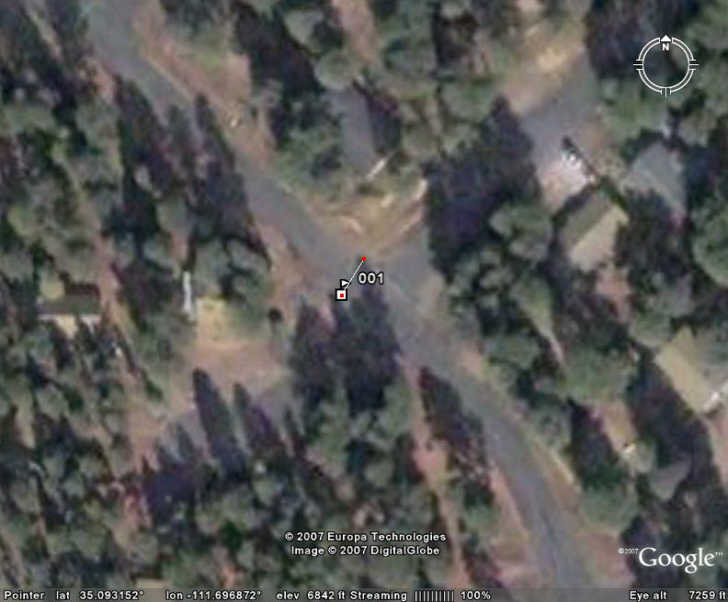
The flag marker is where Google Earth has plotted a GPS waypoint imported as a GPX file, while the drawn line that starts at that marker ends at the actual position where the GPS position was taken. The position plotted by Google Earth is about 30 feet off from the actual position. How come? There are at least two reasons:
1. GPS Error – Even though GPS units give positions to a precision eight decimal places in latitude and longitude, corresponding to an accuracy of about a millimeter or so, the true accuracy with which you can measure a position with GPS is far poorer than that. Consumer GPS unit manufacturers commonly quote an position accuracy figure of plus or minus 15 meters; while modern units can usually achieve better accuracy in real-world use, there is still likely to be some error in the position you measure with GPS. I’ll be covering techniques and tools for maximizing the accuracy of your GPS measurements in a future series of posts; suffice it to say that I took pains to get as accurate a measurement of that position with my GPS as possible.
2. The positions in Google Earth don’t necessarily coincide with the correct position on Mother Earth. In my neighborhood, an exact geographic location shows up offset about 30 feet in Google Earth, or pretty much what we see in the picture above.
So don’t expect to use GPS with Google Earth (or Google Maps) for high-precision positioning and mapping – it’s just not accurate enough for that.
Google Earth’s standard data is .kml (Keyhole Markup Language), or its compressed cousin .kmz. But what you might not know is that Google Earth can open and display other geographic file formats, including the GPX and LOC formats; these are two standard filetypes commonly used in saving geographic data downloaded from GPS units. In the Files => Open menu item in Google Earth, go to the “Files of type” drop-down, select the GPS (*gpx, *.loc) files line, and then open up the GPX file you want to view in Google Earth. Once in Google Earth, you can modify it, and save the modified results as a standard .kml file.
But how do you get the data from your GPS unit into GPX format?
Continue reading ‘Importing GPS Data Into Google Earth I – Proprietary software and EasyGPS’

