In a previous post, I covered DNRGarmin, the best solution out there for downloading data from Garmin GPS units and converting it to the GIS-friendly shapefile format. But what you do you do if you don’t have a Garmin, or you have a mix of Garmin and other brands and want to stick to a single process flow? It can be done, but it takes a bit more work than with DNRGarmin.
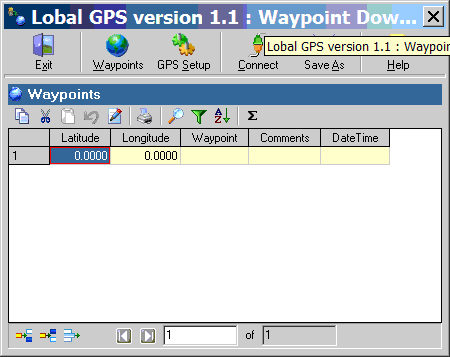
If you have a Magellan unit with a serial interface, and only need to export waypoint data to a point shapefile, you could do worse than Lobal GPS (freeware, Windows only; also works with Garmin serial units). Here’s a screenshot:

A nice, simple interface. “Waypoints” brings up the waypoint screen seen here; “GPS Setup” lets you define the serial COM port and interface for your GPS; “Connect” downloads the data; “Save As” lets you save the waypoint data as a point shapefile, KML file, DBF file, HTML file, or tab-delimited text file. No tracks or routes, though. The icons in the Waypoint section allow other operations on the waypoints, like editing, printing, sorting, filtering, even statistical operations like mean, median, standard deviation, etc.. If you’re only downloading point data with your Garmin unit, you might even choose this program over DNRGarmin because of its simpler interface. I should note that this program worked fine with an older Garmin unit of mine (eMap), but I’m having problems using it with a more modern unit (60Cx); YMMV.
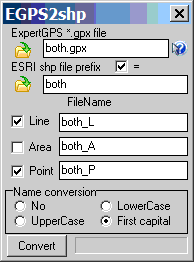
Lobal GPS only does waypoints; if you want to download track and waypoint data and convert them into shapefile format, I’ve found one multi-step process that seems to work well. First, use EasyGPS to download and edit your waypoints and tracks (as described in an earlier post), then save them as a GPX file. Next, open the GPX file in the simple program EGPS2shp (freeware, Windows only):

While it asks for GPX files created using ExpertGPS (EasyGPS’s shareware big brother), it can open and convert EasyGPS GPX files as well; the difference is that ExpertGPS can create GPX files with areas, while EasyGPS can only do waypoints and tracks.
Conversion is pretty straightforward. Open up the GPX file you want to convert using the File button at upper left. If you check the “ESRI shp file prefix” box, EGPS2shp will use the file prefix of the GPX file for the file prefix of the shapefile, appending _L to the line file prefix and _P to the point file prefix, as in the example above. But you can choose your own filenames as well for the shapefiles if you like. If you don’t want a particular type of data created, leave the box next to it unchecked; in the example above, I’ve left “Area” unchecked because it’s an unsupported type. Then click on the “Convert” button, and the shapefiles get created.
If you have GPX files created using other programs, you can try them here, but I’ve had problems getting EGPS2shp to convert them correctly. But if you have such a problem, just open the GPX file in EasyGPS, save it in GPX format in that program, and the problems with EGPS2shp seem to go away. Similarly, if you have GPS data in other odd formats, you can convert it to GPX using GPSBabel, open and save it in EasyGPS, then convert it to shapefile format using EGPS2shp.
Finally, while EasyGPS and EGPS2shp don’t support the creation of area shapefiles from tracks like DNRGarmin does, there’s a way around that. If you create a line shapefile from a track using the above process, you can open it in DNRGarmin, then save it as an area shapefile whose perimeter will be defined by the track (I’ll talk more about this in an upcoming post, including possible complications).
There are two more options I’ll mention without going into detail:
gpx2shp: This freeware command line program claims to be able to convert GPX files to shapefiles. But I’ve never been able to get it to work properly; if any of you can figure it out, please let me know.
GPS Utility: I talked about this program in an earlier post. It can download data from a wide variety of GPS units, and export it in shapefile format. But as the earlier post mentions, this “freeware” version has limitations, and is only intended for evaluation use; the paid version, at $55, isn’t exactly cheap.


I have converted my GPS points into GIS shapefiles using EGPS2shp, yet it does not produce a projection file. Once I create my projection I never end up with the points being correctly spatially oriented. Any comments on what I am doing wrong or could do to rectify this?
EGPS2shp doesn’t create a PRJ file for your shapefile. The data should be exported in geographic coordinates, WGS84, so you’ll to manually specify the projection, or make sure your other data is in that projection.