

There’s one last feature in 3DEM I want to talk about: the ability to create animated fly-bys over terrain, with or without an image overlay. Doing a comparable animation with Google Earth requires either the expensive Pro version, or a copy of FRAPS for $37. While 3DEM’s animations aren’t as fancy as the ones you can get with Google Earth, they’re pretty good.
Archive for the 'Google Earth' Category Page 20 of 25
I’ve posted before about absolute positional accuracy issues in Google Earth. The Google Earth coordinates corresponding to a feature on the earth can be off from the true coordinates of the feature, about 30 feet in my neck of the woods. With the new Google Maps “My Maps” feature, I was curious as to whether you get any improvement in positional accuracy using Google Maps to create KML files for a point, rather than using Google Earth directly.
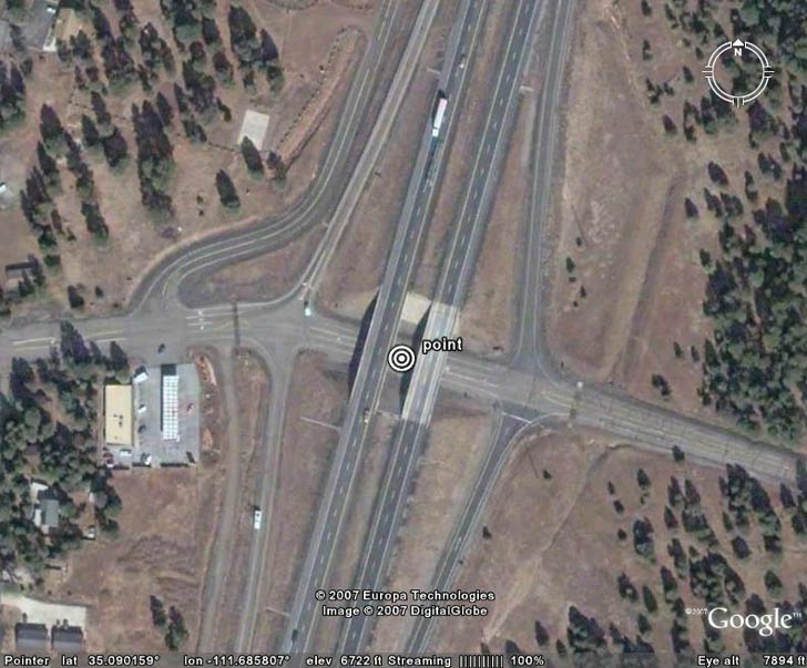
First, I created a point in Google Earth at a highway intersection:
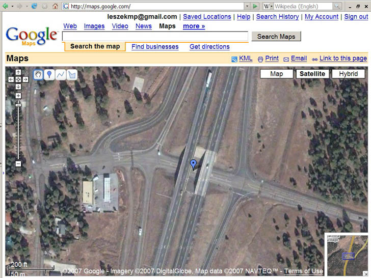
Next, I created a point at the same location in Google Maps “My Maps”:
Exporting the Google Maps point as a KML file, bringing it in to Google Earth, enlarging the view, and measuring the difference between the two:
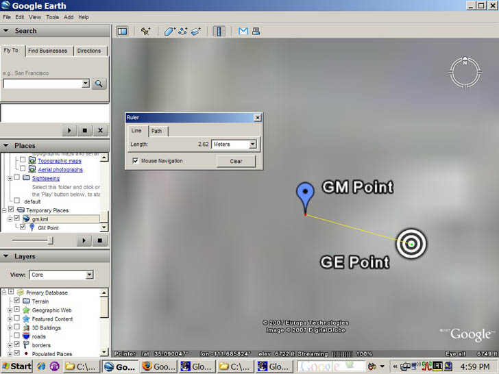
GM point is from Google Maps, GE Point from Google Earth. There’s a slight differential in the two, about 2.5 meters, but that’s almost certainly due to my inability to position the points exactly in the right location in both images, i.e. I’m a klutz. So coordinates match up reasonably well between Google Earth and Google Maps.
But if I plot these points on top of a georeferenced USGS aerial photo:
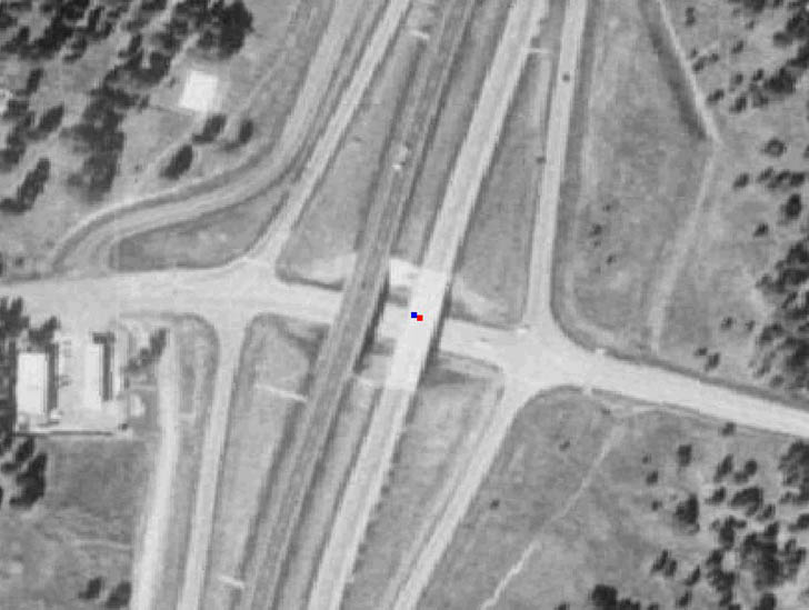
with blue being the Google Maps point, and red the Google Earth point, you can see they’re displaced from the actual position by about 10 meters, or a bit more than 30 feet. That’s comparable in size and direction to what I saw in my previous post on Google Earth accuracy. So you’ll get consistency if you export data from Google Maps “My Maps” to Google Earth, but the coordinates you get in the Google Maps KML file can still be off from the true values. It wouldn’t surprise me if the magnitude and the direction of the shift varied from place to place; if you’re hoping to use either Google Maps or Google Earth for determining positions with high accuracy, you should definitely do a ground check first to see what degree of coordinate shift there may be in your area.
Note: If you have info about the Google Earth or Google Maps coordinate shift for your area, please post it in the comments section below (location and size of shift).
Google Earth Blog posts on Google Maps new “My Maps” feature, which adds additional editing tools to Google Maps and lets you export the created features into a Google Earth layer. Well worth a look.
Google Earth’s native coordinate system is geographic (latitude/longitude, WGS84). So if you have your coordinates in UTM (Universal Transverse Mercator), you need to convert them to geographic first before using them in Google Earth. There’s a small utility that makes using UTM coordinates in Google Earth a lot easier.
UTMFlyer allows you to enter UTM coordinates, and go directly to that point in Google Earth. No installation program, just unzip it into a folder. If it complains about missing .bpl files, you can download them here, and put them either into the same folder as the program or the Windows/System32 folder. Start up the program; if Google Earth isn’t running it will be started up automatically as well. Basic interface is very simple:

Choose the UTM zone and hemisphere (N or S) with the dropdowns, and the UTM coordinates, Easting and Northing separated by a comma. When valid coordinates are entered, the airplane logo will appear at the right – click on that, and Google Earth will go to that location.
But wait, there’s more. The checkmark/exclamation icon is a dropdown menu. In addition to links to the software home page, an info page on UTM, and setting the altitude you fly to, there are also links to “Conversion” and “Extent”. Select Conversion, and the program window expands and adds several option tabs:
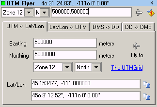
Here, you can enter UTM coordinates and convert them to latitude/longitude (WGS84 only), or do the opposite conversion; clicking on the airplane icon will once again take you to that location. And there’s a bonus decimal degree to degree-minute-second converter (and back again).
Selecting “Extent” from the menu gives you this window:
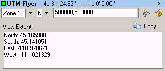
Which shows you the extents of the current view in Google Earth in geographic coordinates.
Here’s a useful tool for identifying which USGS 24K topo quad covers a specific area in the US in Google Earth; it even gives you a handy link to download a GeoTiff of the map from the Internet Archive.
DDS Mapfinder is a KMZ file that opens up in the places pane in Google Earth. Read the warnings and instructions first before using it – if you try and open topo grids for all the states, you may crash Google Earth. Check on an index for a particular alphabetical group of states, and rectangular grids will open on top of those states:
Continue reading ‘Identify And Download USGS 24K Topographic Maps In Google Earth’
Note 1: See this series of posts for info on converting shapefiles to KML format.
Note 2: The current version of the program has a bug that doesn’t let you select a file. The author has indicated on the website that a new version should be out soon, but until then, you may have to use the approach described in either this post or another post. Also available now is an online KML to shapefile converter.
In two previous posts, I covered several multi-step hacks for converting Google Earth KML files to shapefile format, since there wasn’t a single-step free approach to my knowledge. Well, there is now, and it makes the process a lot easier.
Continue reading ‘The Last Word (For Now) On Converting Google Earth KML Files To Shapefiles’
Smoot is an AJAX-based tool that supposedly allows you to create diagrams with custom icons, and then exporting these diagrams into Google Maps or Google Earth by assigning addresses to the icons. I say supposedly because I can’t test it myself – it requires a webserver running PHP and MYSQL, which I don’t have access to, or the time to set up myself. The website has a demo showing the basics of diagramming, but doesn’t support exporting the diagram onto Google Maps or Google Earth because the website host doesn’t support outbound connections. If anyone tries this out, let me know (and send me a screenshot and description if you can). Thanks!
Addendum: This application has been removed, apparently because the author is working on something similar for commercial purposes. See this post at the Google Earth Blog for another application that does something similar.
From the GeoDatum blog comes a link to an application that displays satellite positions and visibility cones in Google Earth. 31 different categories of satellites are available, including weather and communications, but probably of greatest interest here is GPS.