OgleEarth posts about Hey, What’s That?, a website that lets you enter a location and then gives you:
- A panorama of what’s visible from that location, marking the position of peak geographic landmarks
- A list of the peaks, and the ability to show their position relative to your location on Google Maps
- Terrain profiles (elevation versus distance from the location to any point on the map)
- A plot all the areas visible from that location in red on Google Maps (aka the “viewshed” or “weapons fan”)
- Contour lines (zoom in for these)
- Google Earth export of position, viewshed, horizon line and horizon extent. If the viewshed area is large, this might strain the memory capacity of lesser systems.
It uses 30-meter SRTM version 1 data for its calculations, so there may be some quirks depending on whether there are holes in the SRTM coverage for your area. They’re switching over to SRTM version 2 soon, which is better but still not perfect. It only works in the US right now, but according to OgleEarth, they hope to expand coverage worldwide. A cool site! Check the OgleEarth posting for more info.
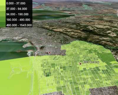
ExtremeTech has an article about the gCensus site, which lets you select US Census tabular data using a web-based interface, and convert it into a Google Earth KML file. Examples include a plot of population density in the Berkeley, CA area:
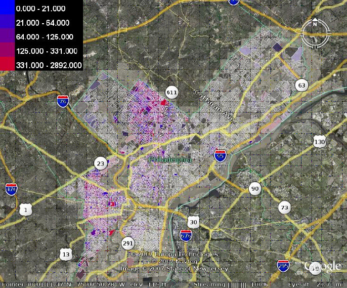
and a plot showing racial segregation in Philadelphia:
Only data from Summary File 1 is currently available, but the site creator intends to add additional data later on.
From the “I’ve been missing the obvious” file: If you have the MapSource program that comes with many Garmin GPS units or Garmin MapSource data disks, you can export waypoints, tracks or routes in the display directly to Google Earth with the View => View In Google Earth command. The data can be imported from a GPS unit, imported from a file (*.gdb, *.gpx, *.mps or *.loc formats supported), or entered manually into the program using its editing tools. Once displayed in Google Earth, you can make a permanent KML file of the data by right-clicking on any the appropriate data entries in the Places Pane, and choosing Save As.
Ogle Earth posts today about two new KML editors:
KMLEditor
NorthGates’ KML Editor
Note: See this series of posts for info on converting shapefiles to KML format.
In the last post, I covered a mildly painful way to convert the vector data (points, paths, and polygons) in Google Earth KML files to shapefile format, while keeping at least the name associated with the points and paths. Today, I’ll describe a simpler and faster two-step process, but one that unfortunately doesn’t keep the name or any of the other KML data associated with the original shapes.
Continue reading ‘Another Way To Convert Google Earth KML Files To Shapefiles’
Note: See this series of posts for info on converting shapefiles to KML format.
I haven’t really found a good way to transform KML files to shapefile format, and certainly not one that preserves most of the attribute information or data associated with the shapes in the KML file. But I’ve come up with a mildly painful, multi-step hack that will allow you to convert the point, path and polygon shapes to shapefile format, and which allows you to keep at least the object name associated with points and paths.
Continue reading ‘Converting Google Earth KML Files To Shapefile Format’
Stumbled across another free Excel spreadsheet that uses the Yahoo geocoder to convert addresses to geographic coordinates. Simple, basic, but does the job.
A link to a compressed version of ExcelGeocoder is available at the top of this page. Run the program to uncompress the spreadsheet, then open it up in Excel. It requires Visual Basic for Applications, so it won’t currently run in OpenOffice, but apparently VBA compatibility is coming soon to OpenOffice’s Calc spreadsheet and other components.The program uses Yahoo’s Geocoder, and requires you to enter a Yahoo ID in the Settings And Instructions tab, a remainder from when you had to register to use the service. Since registration is apparently no longer necessary, you can enter anything you want for a Yahoo ID, but you have to enter something. Paste your address data into the appropriate columns in the spreadsheet, click on the Geocode button in the upper left, and you’ll get back latitude/longitude for those addresses (up to 5,000 per day is allowed by Yahoo).
If you want to use this geocoded data in Google Earth, you can use excel2kml, or if you save the resulting data in CSV format, you can use csv2kml to convert it into a Google Earth file. You can also convert it into a point shapefile using software that I’ll be covering soon.
Just stumbled across another Excel .XLS file with macros that will convert a list of coordinates and descriptions into a Google Earth KML file. Not particularly fancy, but easy to use and works well.
excel2kml uses VBA, so you’ll have to have Excel (i.e. it won’t work with OpenOffice). Open the file in Excel, and enable macros if they’re disabled for security purposes. First page is the data sheet, with a set of sample data already in place: Name, Latitude, Longitude, and Description are the only data fields available. Paste your data into the data sheet (up to 50,000 lines), enter Alt-F8, and run the “Generate KML” macro. A file called “myfile.kml” will be created in the root directory of the C-drive; you can modify the file name and destination in the “File Details” tab. That’s it – tested it with the sample data and a file of my own, and works perfectly. You could probably modify it quite easily to meet any additional requirements you might have.

