blankblank blank


Archive for the 'GIS' Category Page 7 of 23


Check Out The GISVM Virtual Linux GIS Workstation With Your Browser

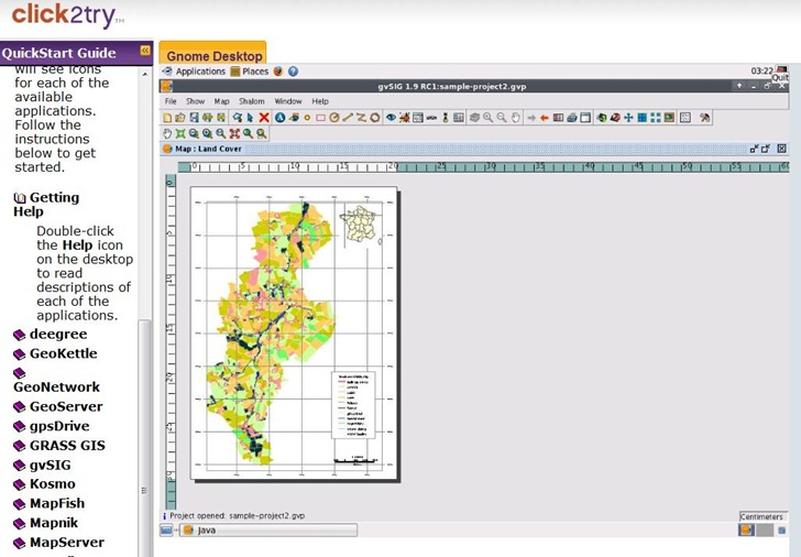
Over a year ago, I posted about GISVM, a Linux GIS workstation in a virtual package that could be run in free VM software like VMWare Player or Virtual Box. You can now try out a more recent release of this package (christened Arramagong, and distributed at the 2009 FOSS4G conference in Australia) in a Java-based virtual machine viewer at the click2try website. You need to register (for free) to save data and settings, but you can try it out without registration. You’ll definitely need a broadband connection to run it, and there’s a connection test to make sure your network link is up to it. Once running, display refresh speed is adequate enough to load up apps and try them out. Wouldn’t want to run the apps full-time on this service, but that’s certainly not the intention for this package  – it’s just to show off what’s available in the distribution. If you like it, you can always download the 1 GB+ full distribution and a free virtual machine environment, and run it at acceptable speed on your own computer.

arramagong

In addition to the apps you see listed above, it also has qGIS, uDig, RGeo, openJump,  and MapTiler


Two Free Textbooks On Geospatial/Geostatistical Analysis

A Practical Guide To Geostatistical Mapping by Tomislav Hengl

Geostatistical mapping can be defined as analytical production of maps by using field observations, auxiliary information and a computer program that generates predictions. The purpose of this guide is to assist you in producing quality maps by using fully-operational open source software packages: R+gstat/geoR and SAGA GIS. Materials presented in this book have been used for the five-day advanced training course "GEOSTAT: spatio-temporal data analysis with R+SAGA+Google Earth" that is periodically organized by the author and collaborators. This is an open access publication!

In addition to a free downloadable PDF copy of the book, you can:

Via Slashgeo.


Geospatial Analysis: A Comprehensive Guide To Principles, Techniques And Software Tools by de Smith, Goodchild and Longley

Topics covered:

  • Geospatial analysis concepts
  • Core components of geospatial analysis, including distance and directional analysis, geometrical processing, map algebra, and grid models
  • Exploratory Spatial Data Analysis (ESDA) and spatial statistics, including spatial autocorrelation and spatial regression
  • Surface analysis, including surface form analysis, gridding and interpolation methods
  • Network and locational analysis, including shortest path calculation, travelling salesman problems, facility location and arc routing
  • Geocomputational methods, including agent-based modeling, artificial neural networks and evolutionary computing

Full text is available online, including diagrams; text is organized by chapter, searchable, and includes Google Translate buttons in 10 different languages. A free PDF is available with purchase of the book.


Online Worldfile Calculator

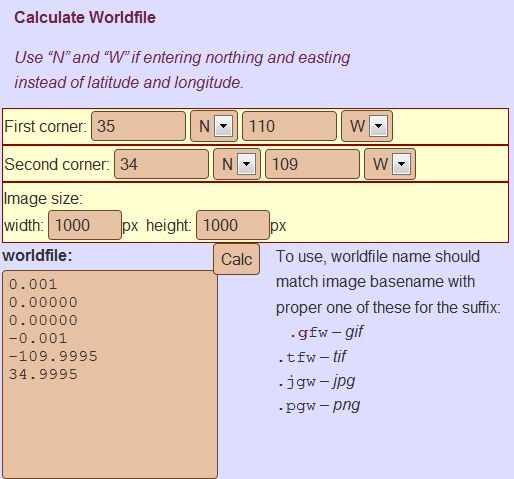
If you have a scanned map image, and know the geographic coordinates of the upper left and lower right corner, plus the image dimensions in pixels, the online World File Calculator will generate a worldfile for that image that you can use to load it into a GIS editor or image viewer:

worldfilecalc

Copy and paste the text in the “worldfile” section into a text editor, then save it with the appropriate file extension as described above on the right.

One major caveat: you need to make sure the coordinate system you use matches the projection of the map image, e.g. UTM coordinates for a UTM projection; geographic coordinates (lat/long) for a geographic projection (Plate Carree), etc.. If you use the wrong coordinate system to generate the worldfile, that’s likely to introduce large errors into your calibration.


gvSIG Version 1.9 Released

It’s been over two years since the last full stable release of the free Java-based GIS gvSIG (runs on Window, Mac, and Linux). I thought that version 2.0 would be out soon, but got fooled – the new version is 1.9. This is a huge enhancement, with major functionality improvements in:

  • Raster analysis and remote sensing
  • Symbology and labeling
  • Topology
  • Network analysis
  • Vector editing and manipulation
  • Export to the Windows Mobile version of gvSIG
  • And more; see the New Features log for more info

One minor problem with gvSIG for English users has been translation issues with the installation program and user interface (gvSIG originates in Spain, from the Valencian Regional Council for Infrastructures and Transportation (CIT)). Oxford Archaeology Digital created a modified version of gvSIG 1.1.2 (the last stable release) which cleaned up some of these language issues, and the web page indicates that they’re working on a comparable English-oriented installer and interface for version1.9. I’ll keep a watch on that page, and post when the new version is ready.


MapWindow GIS Updated To Version 4.7; Next-Gen Version 6 Beta Available

It’s been over a year since I last posted about a version update (4.5) for the free Windows GIS MapWindow (topic of multiple previous posts). Just noticed that version 4.7 was released just a bit more than a week ago. Improvements since 4.5 include:

  • Stability improvements, particularly when dealing with large numbers of shapes in shapefiles
  • TauDEM/Automatic Watershed Delineation Help Files
  • Progress indicator improvements in many plug-ins
  • Unit conversions available for more standard units and more accurate
  • New image properties in MapWindow (Use Histogram, Allow Hillshade, Buffersize, Image Color Scheme, Set to Grey
  • Zooming with mouse wheel
  • Updated GDAL projection library
  • Added GEOS shape functions (Contains, Crosses, Touches, Intersects, Overlaps, etc.)
  • New printing plug-in
  • New image properties (Use Histogram, Allow Hillshade, Buffersize, Image Color Scheme, Set to Grey)
  • Bug fixes and speed improvements
  • Improved documentation

And if you want to look at the future of MapWindow, there’s a Codeplex development page for MapWindow 6 where you can download the latest beta (which looks to be in a pretty usable state) and fairly extensive documentation. What’s the difference between MapWindow 4.x and 6? From the Forward:

The MapWindow 6 platform is a major step forward. It is completely .NET based, has no COM or ActiveX references, and is totally built around the idea of interfaces and components. If you are a developer you can rebuild the MapWindow 6 desktop application in about 10 minutes by simply assembling the correct components and hitting the “compile” button. If you are an end user, you will find significantly improved symbology and printing capabilities and a new modeling toolkit and environment that are just plain awesome.

First stable release of MapWindow 6 is scheduled for the first half of 2010, hopefully at the 1st International MapWindow Users And Developers Conference.


Great Introductory GIS Tutorial And Screencast Series

The Department of Land Affairs, Eastern Cape, South Africa has created a terrific tutorial series on GIS called “introducing GIS”. PDF worksheets and video screencasts cover topics like vector and raster data, attributes, topology, coordinate systems, map production and spatial analysis in a clear and easy-to-follow fashion. The worksheets are freely distributable under the terms of the GNU Free Documentation License, while the screencasts are released under Creative Commons. While you can watch the screencasts in your browser, they are a bit small – I would recommend downloading them so that you can open them in a stand-alone video viewer that you can resize to larger dimensions for easier viewing. Right-click on the video link and choose “Save as”. For that matter, if you download all the screencasts and worksheets and put them on a DVD, you have a great educational resource to share and distribute.

The site has a custom Windows installer of the open source GIS Quantum GIS, including the data presented in the tutorials. However, Quantum GIS also runs on Mac and Linux, and they offer the tutorial data as a separate download; find the link at the bottom of the web page. For that matter, the Quantum GIS Windows installer they have is version 1.0.2, while the most recent stable release version for Windows is 1.2.0-1. So even if you have Windows, you may want to download the data separately, and install the most recent version of Quantum GIS using the osgeo4w installer.


The Big List Of Image Registration / Georeferencing Software

If you want to use a raster map image in a GIS program, it needs to be calibrated so that the software will know the geographic position of every pixel in the image. This calibration data can be embedded in the file, as in GeoTiffs and MRSID files, or external as in worldfiles. If you have a raster map image which doesn’t include this calibration data, you’ll need to create it yourself; this process is called  “image registration” or georeferencing. There’s a number of free programs that can perform this function, and I’ve put together a list of some of them below; if you know of others, please let me know and I’ll add them. And if I’ve included a program that doesn’t do georeferencing (very possible, since I haven’t used all of them), let me know that as well and I’ll drop it from the list.

One thing to keep in mind: some of the programs only work correctly if the map image is already in a specific map projection like UTM or geographic, and you use the same coordinate system to georeference the image. As a general practice, it’s always best to use the same coordinate system the map was created in to georeference it. For example, if you have a map in the UTM projection, and use geographic coordinates to georeference it, the resulting calibration is unlikely to be accurate over the entire map (unless you’re at the equator). Some programs let you warp the map image to get it to match the coordinate system, a process known as “rubber-sheeting”; this is especially useful for those maps that aren’t drawn accurately, like old or hand-drawn maps, or maps created in no-longer-used coordinate systems.

BTW, I haven’t used most of these for georeferencing – GlobalMapper is my program of choice for this function. It’s not free, or even cheap, but it works great for georeferencing, including rubber sheeting. For beginners, I’d suggest looking at MapWindow, qGIS or MicroDEM first before going on to the more advanced software.

CHIPS For Windows

DIVA GIS

e-Foto

GRASS

gvSIG

HyperCube

ILWIS

Image Georeferencer

LandSerf

MapWindow

MicroDEM

MicroMSI (link may be dead)

Opticks

OSSIM

qGIS

QLandKarte

RasterStretch

Regeemy

SAGA

SavGIS

Spring GIS

TransGen

xBit

Online map rectification tools

MapWarper

Metacarta Map Rectifier

NYPL Map Rectifier

Old Maps Online Georeferencer (in development)


Free Sampling Design Tool Extension For ArcGIS

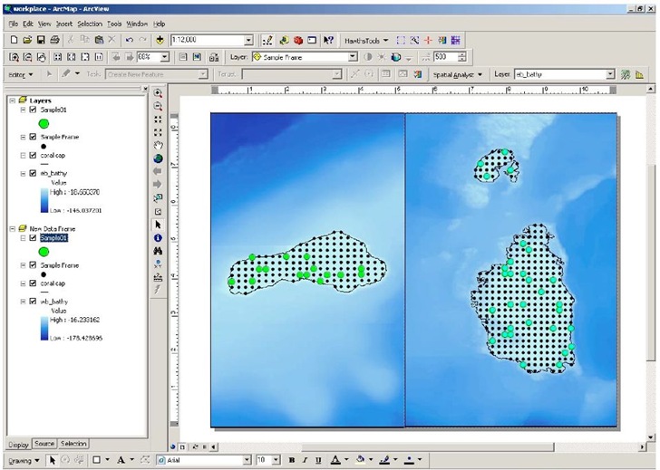
The Sampling Design Tool is another free ArcGIS extension from NOAA’s Center for Coastal Monitoring and Assessment, the source of the Habitat Digitizer Extension I posted about last week.  Key features (from the PDF manual):

  • Spatial sampling –sampling and incorporation of inherently spatial layers (e.g.
    benthic habitat maps, administrative boundaries), and evaluation of spatial
    issues (e.g. protected area effectiveness)
  • Scalable data requirements – data requirements for sample selection can be
    as simple as a polygon defining the area to be surveyed to using existing
    sample data and a stratified sample frame for optimally allocating samples
  • Random selection -eliminates sampling biases and corresponding criticisms
    encountered when samples are selected non-randomly
  • Multiple sampling designs – simple, stratified, and two-stage sampling
    designs
  • Sample unit-based sampling – points or polygons are selected from a sample
    frame
  • Area-based sampling – random points are generated within a polygon
  • Analysis – previously collected data can be used to compute sample size
    requirements or efficiently allocate samples among strata
  • Computations –mean, standard error, confidence intervals for sample data
    and inferences of population parameters with known certainty
  • Output – geographic positions in output simplifies migration to global
    positioning systems, and sample size estimates and sample statistics can be
    exported to text files for record keeping

Example of random sampling (from the manual):

randomsampling