blankblank blank


Archive for the 'Garmin' Category Page 12 of 13


Converting OpenStreetMap Data Into GPX Or Garmin .img Format

The OpenStreetMap project is “a free editable map of the whole world”, created by users with GPS data or by tracing over Yahoo Maps images (allowed by Yahoo) or public domain Landsat data. Data is viewable by anyone; registration assigns you a username and password that lets you contribute your own data to the project, using a multi-platform map editor like JOSM or Meerkartor. JOSM also lets you save downloaded data from OpenStreetMap, and this data can be converted to the .img format used by Garmin mapping GPS units, or converted to a GPX file for general import into GPS units.

The current OSM data in Garmin .img format is available for the UK, South Africa, and Africa at the Mkgmap wiki site, and for Germany/Netherlands and the entire world at this site. But if you want the most recent data, data subsets for different areas, or don’t want the entire dataset for the world, you can download data for a specific area from OpenStreetMap and convert it yourself to a Garmin .img file. Data coverage is still spotty, so you should check the OpenStreetMap site to see whether the area you’re interested in has data. If yes:

1. Click the “Download some data from the OSM server” link in JOSM, and specify the latitude/longitude bounds of the area you’re interested in (no more than 0.25 degrees square) (note: you’ll need to have entered your OSM username and password in the preferences section).

2. Save the downloaded data as an *.osm file if you want to convert it to Garmin format, else save it as a GPX file.

3. Use the command line Java program Mkgmap to convert the *.osm file to a Garmin img map file (always the same output filename, “63240001.img”, but you can rename it to a different 8-digit number after creation) . If your osm file is called test.osm and is in the same directory as mkgmap.jar, the command syntax is “java -jar mkgmap.jar test.osm”. Enter the appropriate data path if it’s located in a different directory, but the 63240001.img file will always be created in the directory where mkgmap.jar is located. If you’d prefer a GUI, I’ve created a simple one for Windows that you can download here; unzip it to the same directory as mkgmap.jar and run it. The *.osm file will have to be in the same directory as mkgmap.jar for this GUI to work; sorry about that.

4. Upload the .img file to your Garmin GPS using a program like sendMap, or MapUpload if you have a compatible Garmin unit. For GPX files, use the upload program of your choice (e.g. GPS TrackMaker or EasyGPS).

Thanks to David from the UK for the tip.


Garmin MapSource For Free

Note: Garmin’s free BaseCamp software can now be used to view and install any mapsets, including non-Garmin ones; it’s not as good as MapSource, but it is free, and is also available for both PC and Mac. See this tutorial at the GPS File Depot for more info.

Most current Garmin GPS units come with a free version of MapSource, their software for uploading data/maps and downloading waypoints. tracks, routes, etc to and from Garmin GPS units. But if you’ve lost or misplaced your install disk, you’re out of luck; while Garmin has a downloadable updated version of MapSource on their website, it requires that you have the earlier version installed on your disk. Try and install it directly, and it will abort after telling you it can’t find a previous version.There’s a way around that “earlier version” limitation that lets those with a legitimate reason install MapSource on their computer. First, download and install a copy of Garmin’s free Training Center software, designed mainly for use with their fitness GPS units (ForeRunner and Edge). Once this software is installed, you can download and install the MapSource update file, and the full version of MapSource will be up and running on your computer (confirmed this on a system of my own).

Note: this will only have the MapSource base road data. If you have any additional map data you’ve purchased (like Topo, City Navigator, MetroGuide), you’ll need to re-install that from the original data disks. But since that process installs an original copy of MapSource on your computer, that makes the above irrelevant for you.

An alternate method is described here, but I haven’t tried it out myself.

What’s it good for? Well …

  • If you have a Garmin GPS, it’s good for uploading and download data, including maps if your Garmin unit supports them and you have the data
  • Open files in gdb, mps, gpx and loc formats
  • Create waypoints, routes and tracks; the track editor in particular is easy to use.
  • It comes with a world road basemap, and you can add maps from free sources like SmellyBiker, MetroWizzz or the Garmin Maps site, or even make your own
  • Save point, route or track data in gdb, mps, gpx, tab-delimited text and DXF formats
  • Export waypoint, route and track data directly to Google Earth

Hat tip to GS.

If you poke around this site, you’ll find other useful free GPS software that does some of what MapSource does, plus many things that MapSource doesn’t. Take a look in particular at postings in the categories for Garmin, GPS and GPX.


A KML To CSV (And CSV To KML) Converter For Spreadsheets And Garmin POI Files

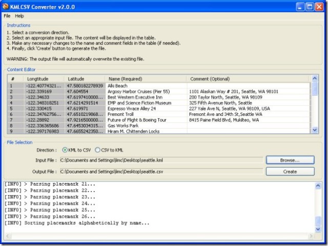
Newer Garmin GPS units support the upload of sets of POIs, containing both position data and descriptions of the Points Of Interest. The KMLCSV Converter is a Java application that lets you convert placemarks created in Google Earth and saved as a KML file into a CSV (Comma-Separated Values) file compatible with Garmin’s POI Loader; this CSV would also be compatible with most spreadsheet programs as well. The process is straightforward:

1. Create placemarks in Google Earth using the “Add Placemark” tool, search, or other means.

2. Add a description to the placemark.

3. Drag all the placemarks you want to save into a single folder.

4. Save the folder as a KML file

5. Convert it to a CSV file with the KMLCSV Converter Program (screenshot from website)

screenshotkmlcsv

6. Upload the CSV POI file to your Garmin with the POI Loader program, or into your spreadsheet as a standard CSV file.

There’s a short PDF tutorial file that covers these steps quite clearly with screenshots.

You can also convert CSV files, either POI files or spreadsheet files created by yourself or someone else, into KML files for viewing in Google Earth; a search for “Garmin POI” files on the web will bring up links to many sources, both free and paid. But I prefer the program csv2kml for that purpose.


Converting A Garmin USB GPS Connection To Multiple Serial NMEA Connections

Many GPS-related programs require an NMEA connection to your GPS through a serial port. But many new computers don’t include a serial port anymore, while many new GPS models, particularly Garmin, only have a proprietary USB interface and not a serial NMEA interface. For computers that don’t have a serial port, you can always buy a USB to serial converter like those from Keyspan. And for Garmin USB-only GPS units, there’s a program called GPSGate from Franson that converts the USB connection to multiple virtual serial NMEA ports, $10-30 depending on how many ports you need. Garmin offers a similar program for free called “Spanner” for their GPS 18 model, a USB receiver/antenna that’s designed to plug in to a notebook’s USB port and interface with programs running on it. What Garmin doesn’t say is that “Spanner” will also work with some, albeit not all, of its other GPS receiver units; you’ll have to experiment to see if it works with your model. And even if your Garmin has both serial and USB interfaces, like my Garmin 60Cx, using this program can save you the expense of a GPS-to-serial cable, a USB to serial converter if your computer doesn’t have a serial port, or both. Note: Only works with XP; doesn’t work with Vista and Windows 7.

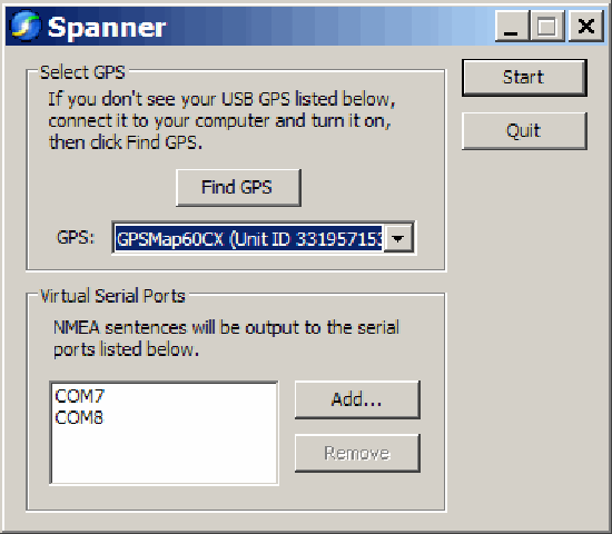
Download the Spanner program from the Garmin website, and install it. The program has only one configuration window:

Spanner

You need to have your GPS turned on, connected to your computer via USB, and using the Garmin protocol; if any of these isn’t true when you start Spanner, make it so, then click “Find GPS”. At the bottom, use the “Add” button to add a virtual serial port to your computer for use by your software as an NMEA connection. Make sure you choose a number for your COM port that doesn’t conflict with any your computer currently has. I believe that Windows can handle COM1 through COM 255, but keep in mind some software programs won’t support ports higher than COM8, or even COM4.

I’ve had two programs running simultaneously, each one getting NMEA data from a different COM port, and given that COM ports are pretty slow, I’d guess that you could add a few more without putting a serious strain on your computer’s resources.


USAPhotoMaps: GPS Functions

USAPhotoMaps has built-in GPS interface capabilities for Garmin GPS units; it also supports the general NMEA GPS interface for other units. While there are a lot of GPS functions, they’re a mixed bag. Waypoint creation, export, and import on the fly are pretty easy (with some minor quirks), and USAPhotoMaps is my program of choice for quickly creating waypoints on a topo map or aerial imagery and then exporting them to my GPS unit. Saving and manipulating waypoint data is more problematical, and dealing with routes and tracks is a major headache. It seems as though some of these features were bolted on rather than integrated with the main program in a logical fashion. My experiences were with a Garmin GPS (60Cx); YMMV.

Continue reading ‘USAPhotoMaps: GPS Functions’


Cheap Worldwide Road And Contour Maps For Garmin GPS Units

Most handheld Garmin GPS units come with a baseline road map that displays major roads for either the Eastern or Western hemisphere, plus the ability to display greater detail using uploaded map data. Garmin sells a line of CD/DVD disks with data for various parts of the world, and third-party sources offer maps with greater details for specific countries (a Google search should reveal even more). Many of these datasets are expensive, and data is unavailable for some areas of the world. There’s a cheaper option that offers worldwide data, including coverage of areas not covered by commercial products, but with some limitations in quality and detail.

Continue reading ‘Cheap Worldwide Road And Contour Maps For Garmin GPS Units’


Determining Local GPS Satellite Geometry Effects On Position Accuracy

Broadly speaking, errors in the position a GPS receiver gives you are due to two factors: the precision with which the distance to each GPS satellite is known, and the geometry of the satellites, i.e. how closely or far apart they’re spaced across the sky. Distance errors can be compensated for by using WAAS, post-processing, averaging, and other techniques, but satellite geometry is a fundamental limiting factor. The maximum position accuracy you can achieve is limited by GPS satellite geometry.

Continue reading ‘Determining Local GPS Satellite Geometry Effects On Position Accuracy’


Free Garmin GPS Unit Auto-Routing With MetroGuide Maps + Free European Basemap

Many of Garmin’s mid-level handheld GPS units support auto-routing: automatic determination of the shortest distance or fastest time route to a destination, with turn-by-turn instructions (check your owner’s manual to see if your unit supports auto-routing). However, it was necessary to buy the City Navigator map disks to do turn-by-turn routing on-the-fly on your GPS. The cheaper MetroGuide map disks were able to do this in Version 4, but starting in MetroGuide Version 5 you could only do MetroGuide routing in the MapSource or nRoute programs on your PC, not on-the-fly on your GPS. MetroGuide is not only cheaper than City Navigator, it’s also unlocked, meaning you can use it on multiple GPS units; City Navigator is locked for use on a single GPS unit. But there’s a free piece of software that enables auto-routing on your GPS unit using MetroGuide maps.

Continue reading ‘Free Garmin GPS Unit Auto-Routing With MetroGuide Maps + Free European Basemap’