blankblank blank


Archive for the 'Garmin' Category Page 11 of 13


Creating Custom Waypoint Icons For Garmin GPS Units III – Custom Waypoint Icons In MapSource

Note: Version 6.15.3 of MapSource accidentally dropped support for custom waypoint icons; version 6.15.4 puts it back. Make sure you have the most recent version.

The two previous posts in this series dealt with creating and uploading custom waypoint icons to supported Garmin GPS units. But while third-party software for handling GPX data (both upload and download) will download the waypoints, most (if not all) don’t support display of these custom waypoint icons. For that, you’ll have to use Garmin’s MapSource program (aka Trip and Waypoint Manager), and set up custom waypoint icon graphics so that MapSource can import and use them.

Continue reading ‘Creating Custom Waypoint Icons For Garmin GPS Units III – Custom Waypoint Icons In MapSource’


Creating Custom Waypoint Icons For Garmin GPS Units II

Note: Version 6.15.3 of MapSource accidentally dropped support for custom waypoint icons; version 6.15.4 puts it back. Make sure you have the most recent version.

In the first post of this series, I started describing the process of creating and uploading a custom waypoint icon to a Garmin mapping GPS unit; little of what follows will make sense unless you read that first. Today, the thrilling semi-conclusion!

Continue reading ‘Creating Custom Waypoint Icons For Garmin GPS Units II’


Creating Custom Waypoint Icons For Garmin GPS Units I

Note: Version 6.15.3 of MapSource accidentally dropped support for custom waypoint icons; version 6.15.4 puts it back. Make sure you have the most recent version.

Modern handheld Garmin GPS units with map displays come with an absurd number of icon choices to use when designating and displaying a waypoint. My Garmin 60Cx comes with:

  • 18 Transportation
  • 12 Markers
  • 18 Civil
  • 24 Outdoors
  • 24 Marine
  • 18 Navaids
  • 24 Signs
  • 24 Points of Interest

But if those aren’t enough for you, or a specific icon graphic you’d like to see isn’t included, it’s possible with many Garmin units (like my Garmin 60Cx) to create your own waypoint icons and upload them to your GPS unit. To find out if your unit supports Custom waypoint icons, create a waypoint, select the icon image, and see if “Custom” as a subcategory of waypoint icons, along with the others listed above:

Continue reading ‘Creating Custom Waypoint Icons For Garmin GPS Units I’


Converting Digital Elevation Models To Shapefile/DXF Contours

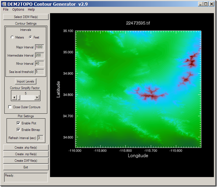
There are any number of ways to convert a digital elevation model (DEM) to shapefile vector contour lines, but most of the ones I’ve come across have had limitations of one sort or another. The best solution I’ve come across is the free program dem2topo; while it only supports a limited number of DEM formats, it has more flexibility in units and simplification than other methods, and the graphical interface is easy to use (unlike some command-line programs).

The program is written in IDL, an interpreted language, and you’ll have to download and install the IDL Virtual Machine first (free, but a 100 MB download, requires registration, and you may get a sales call). DEM formats supported are Canadian Digital Elevation Data (CDED), and nominally the GeoTiff format, but I’ve had some GeoTiff DEM rejected by the program for unknown reasons. NED GeoTiffs from the USGS Seamless Server work fine, and if you can open your DEM in the program 3DEM (which supports a number of DEM formats) and export it as a GeoTiff DEM from there, those should work with dem2topo as well. Once you’ve loaded your DEM into dem2topo:

11-24-2007-8.02.08 PM11-24-2007-8.03.14 PM12-15-2007-11.09.23 PM

you can choose contour intervals (meters or feet, regardless of what the original units were), the simplification factor (larger simplifies more, but at the cost of detail), whether to close the outer contours, and whether to display the contours as they’re being processed (for faster processing speed, leave these unchecked. More on these options is available in the helpfile.

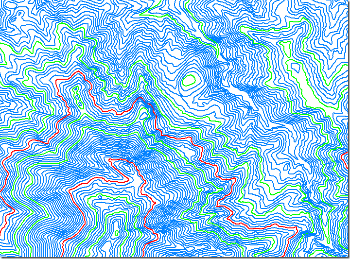
Once configured, you have the option of converting the DEM into either shapefile contours, DXF contours, or into the .mp format used in creating maps for Garmin GPS units. For the shapefile format, major/intermediate/minor contour intervals are defined in the DBF file by the same hex code used in the .mp format: 0x0020 for minor contours, 0x0021 for intermediate, and 0x0022 for major . Processing speed will depend on the size of the DEM and level of detail, but don’t expect instant results. Converting the above 10-meter DEM to shapefile contours took well over an hour, albeit on my fairly pokey 2.4 GHz system; more memory also speeds up the process. But the results are worth the time; here’s a blow-up of the shapefile contour map of a very small section of this DEM:

contours

A simple process, and if you run into problems, the help file is well done.


Google Maps Search Interface For Garmin .img Maps

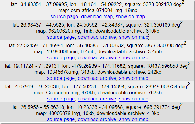
In a previous post, I listed off a few sources of free .img maps that can be uploaded to a Garmin GPS unit; GPS Tracklog recently posted a few more as well. There’s a new site called GPS MapSearch that makes the process of locating these maps a lot easier, using a Google Maps interface. Click on a point in Google Maps, and a list of Garmin-compatible .img maps for that area will appear in the right text box:

11-24-2007-8.02.08 PM11-24-2007-8.03.14 PM12-14-2007-8.37.54 AM

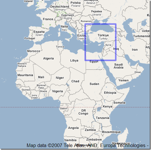
listing the geographic extents, with links to the original web page and the downloadable map file. Click on “show on map”, and the extents covered by that particular map will be displayed in the Google Maps interface:

11-24-2007-8.02.08 PM11-24-2007-8.03.14 PM12-14-2007-8.41.02 AM

Area coverage, level of detail, and quality of data are likely to vary widely, and it looks like some of the maps sources listed above aren’t included (the author is soliciting that data, so that may change). But it’s still a really nice tool to have, especially if you’re looking for Garmin .img maps in areas that aren’t covered by commercial products. Once you have a .img map, you can easily add it to your MapSource dropdown list using Mapset Toolkit.


Beta Version Of DNRGarmin

One of the first posts on this blog was about the 5.1.1 stable version of DNRGarmin. Long story short, if you work with GIS and you use Garmin units for your data acquisition, this program is a must-have. It can upload/download data in text, DBF and shapefile formats to/from Garmin GPS units, and also comes with an extension for direct interfacing with ArcGIS software. Version 5.1.1 had some utility for non-Garmin GPS units and applications, but version 5.2, currently in beta, has some new features that make it a worthwhile installation for anyone with a GPS.

DNRGarmin has actually been in beta for a while, and I’d been waiting to see if it would come out of beta; the date on the last release is 5/18/07. The webpage indicates in big bold letters that in the beta, “THE ERROR RELATED TO USB CONNECTIVITY AND LOGIN RIGHTS HAS NOT YET BEEN RESOLVED“. But I’ve installed it successfully on 3 different computers without encountering this problem, so there’s a decent chance it should work on yours as well.

New features in version 5.2 include:

  • Load data in KML and GPX (in addition to the previous options of text, DBF and shapefile formats)
  • Load data directly from the “My Place” pane in Google Earth
  • Save data in KML and GPX (along with the previous options of projected/unprojected shapefiles, text and DBF)
  • Convert between the different formats
  • Collects waypoint time data from supported units

Note: The new version’s ArcGIS extension no longer works with ArcGIS 8.x, only 9.x. If that’s important to you, you should stick with version 8.1.1, still available on the web page. But the new version works fine in stand-alone mode.


Sources For Free Garmin .img GPS Map Files

As mentioned in the previous post, you can use MapSet Toolkit to add any .img Garmin map file to MapSource. If you want to try out the process on some free .img files, here are some sources for .img files, as well as some data in executable files that install it automatically in MapSource without the need for MapSet Toolkit:

  • Mkgmap wiki: .img files for the UK, South Africa, and Africa
  • OpenStreetMap wiki: Files for Germany/Netherlands and the entire world (read the caution for the latter, though; it might crash MapSource if you install it there)
  • GPS Vector Map Morocco has Garmin maps for Morocco and Western Sahara.
  • Yunnan Explorer has some topographic maps for areas of Yunnan Province in China.
  • cgpsMapper MapCenter (and MapCenter2): Maps from around the world, browsable by country and type. Coverage is hit-and-miss, but for some countries it’s very good. For example, the New Zealand Open GPS Project is creating road maps for the entire country as a complete set with an installer that puts them automatically into MapSource.
  • Tracks4Australia has installable map tiles for all of Australia.
  • The GPS Maps site has downloadable maps for Garmin mapping GPS units. Levels of detail included are mixed, but the maps can include topographic contours, land details, and road maps in various levels of detail (either VMAP0 or VMAP1). Areas covered:
    • The Caribbean (including Cuba and parts of South Florida, Central and South America)
    • Bermuda
    • Japan
    • Antarctica
  • Greece GPS Maps has … maps of Greece.
  • And one of these days, I’ll get around to posting on some of the free options for creating your own .img files …


Adding Garmin .img Map Files To MapSource

8/29/09: Some have reported issues with the latest versions of both cgpsmapper (0098c) and MapSet Toolkit (1.62). If you have a problem with these, try using older versions of both programs, available at this link. Also, if you have problems with installing a mapset, try right-clicking on the program and choosing “Run As Administrator”; Windows crappy security system sometimes blocks programs from modifying the Windows registry, which MapSet Toolkit needs to do to install a mapset.

In the last post, OpenStreetMap data was converted to a Garmin .img map file, which can be directly uploaded to a Garmin GPS unit using SendMap or MapUpload software. But it’s more convenient to use the MapSource software that comes with most Garmin GPS units to do this, since you can preview the map data in that program, and create/upload multiple maps and mapsets easily. The best program I’ve found to do this is MapSet Toolkit; you’ll also need the map compiling program cgpsmapper, free for creating basic maps for personal use.

Using the process in the previous post, I downloaded some street data for London, and converted it to a Garmin .img file. I then used the following steps to add the .img file to MapSource:

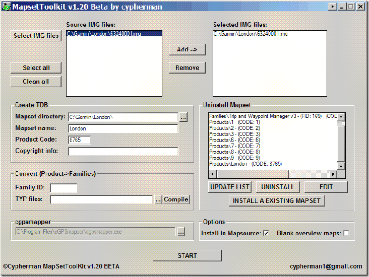
1. Created a subdirectory in my C:\Garmin directory called “London”, and copied my “63240001.img” file there. Note: MapSet Toolkit will only recognize .img files with a numerical filename. If you rename the file with a non-numerical name, it won’t show up.

2. In Mapset Toolkit, chose that file with “Select IMG files”.

3. Highlighted that file, and “Add”ed it to the selected IMG files. You can add multiple .img files as part of a single set of files.

4.Chose the same directory that contained the .img file as the “Mapset directory” to be used

5. Assigned a name to the mapset, “London”

6. Chose a 4-digit “Product Code” number (“8765” in this example); the only limitation is that it not conflict with any other product codes (which are displayed in the “Uninstall Mapset” box at the right).

7. You can enter copyright info if appropriate, but it’s not required here

8. At lower left, chose the directory where cgpsmapper.exe is located (usually the C:\Program Files\cGPSmapper directory), and selected the cgpsmapper.exe file

9. The “Convert (Product>Families)” section was left blank; more information about Family ID and TYP files is available in the cgpsmapper manual.

10. Checked the box marked “Install in MapSource”. Checking “Blank overview maps” will eliminate the map preview in MapSource. I’ve found that for some mapsets, leaving this box unchecked will result in a crash of cgpsmapper, and a failure of the installation; in that case, check the box and try again.

11. Clicked “Start”, and shortly thereafter got a message box saying “Convert termined” (sic).

12. In the “Uninstall Mapset” section, there’s now a new listing for the added map.

The program screen after all these operations looks like this:
Mapset Toolkit

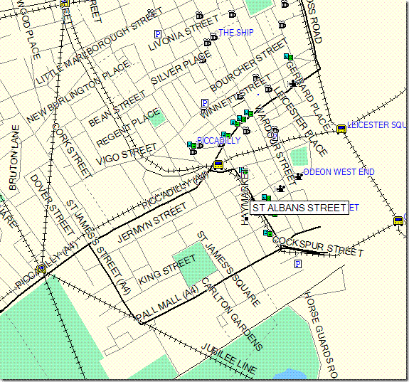
If I now open Mapsource, the dropdown at the upper left has a selection for “London”; selecting it brings up the OpenStreetMap data:
Londonmap

I can now select this dataset along with any others I might want, and upload it to my Garmin.

You can also use the “Uninstall Mapset” section to remove mapsets from MapSource as well. Occasionally, installing a mapset will cause problems with MapSource starting up; usually, uninstalling the mapset with MapSet Toolkit will fix that problem. You may have to run the program in “Administrator” mode to get this to work (see the comments below).

There’s more complete documentation available in PDF format at the MapSet Toolkit website. And a more complete, technical tutorial on doing this is available at the GPSFileDepot.

Addendum: There are two other programs floating around that can also add .img files to MapSource. M3 is available at MalsingMaps.com, where you can also find free Garmin maps for Borneo, Malaysia and Singapore; free registration required. However, I’ve found that if you install a MapSet using M3, other mapsets installed by either MapSet Toolkit or with the Garmin installer can disappear off of the dropdown menu (they come back after you uninstall the offending mapset). GPS Map Manager is better than M3, but MapSet Toolkit has a better interface and more capabilities.